 |
|
Umatilla Municipal Airport |
Coordinates: 28°55′22.50″N 081°39′07.000″W / 28.922917°N 81.65194°W / 28.922917; -81.65194
| Umatilla Municipal Airport |
| IATA: none – ICAO: none – FAA LID: X23 |
| Summary |
| Airport type |
Public use |
| Owner |
City of Umatilla |
| Operator |
Tim Scobie |
| Serves |
Umatilla, Florida |
| Location |
Lake County, Florida |
| Elevation AMSL |
107 ft / 33 m |
| Runways |
| Direction |
Length |
Surface |
| ft |
m |
| 18/36 |
2,290 |
698 |
Asphalt |
| Statistics (2002) |
| Aircraft operations |
5,000 |
| Based aircraft |
15 |
| Source: Federal Aviation Administration |
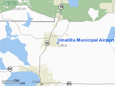
Umatilla Municipal Airport (FAA LID: X23) is a public-use airport located 1 mile (1.6 km) east of the central business district of the city of Umatilla in Lake County, Florida, United States. The airport is publicly owned.
The above content comes from Wikipedia and is published under free licenses – click here to read more.
Location
& QuickFacts
|
FAA Information Effective: |
2007-01-18 |
|
Airport
Identifier: |
X23 |
|
Airport
Status: |
Operational |
|
Longitude/Latitude: |
081-39-06.2680W/28-55-21.9540N
-81.651741/28.922765 (Estimated) |
|
Elevation: |
107 ft / 32.61 m (Estimated) |
|
Land: |
21
acres |
|
From
nearest city: |
1 nautical miles E of Umatilla, FL |
|
Location: |
Lake County, FL |
|
Magnetic Variation: |
03W (1985) |
Owner
& Manager
|
Ownership: |
Publicly owned |
|
Owner: |
City Umatilla |
|
Address: |
P.o. Box 2286
Umatilla, FL 32784 |
|
Phone
number: |
352-669-3125 |
|
Manager: |
Tim Scobie
CITY ADMINISTRATOR. |
|
Address: |
P.o. Box 2286
Umatilla, FL 32784 |
|
Phone
number: |
352-669-3125
FAX 352-669-8313, E-MAIL ADDRESS: CUATILLA@AOL.COM. |
Airport
Operations and Facilities
|
Airport Use: |
Open to public |
|
Wind
indicator: |
Yes |
|
Segmented
Circle: |
No |
|
Control
Tower: |
No |
|
Lighting
Schedule: |
DUSK-DAWN |
|
Landing
fee charge: |
No |
|
Sectional
chart: |
Jacksonville |
|
Region: |
ASO - Southern |
|
Boundary
ARTCC: |
ZJX - Jacksonville |
|
Tie-in
FSS: |
PIE - Saint Petersburg |
|
FSS
on Airport: |
No |
|
FSS
Toll Free: |
1-800-WX-BRIEF |
|
NOTAMs
Facility: |
PIE (NOTAM-d service avaliable) |
|
Federal Agreements: |
N |
Airport
Communications
Airport
Services
|
Airframe Repair: |
NONE |
|
Power Plant Repair: |
NONE |
|
Bottled
Oxygen: |
NONE |
|
Bulk
Oxygen: |
NONE |
|
Runway Information
Runway 18/36
|
Dimension: |
2290 x 50 ft / 698.0 x 15.2 m |
|
Surface: |
ASPH, Poor Condition
CRACKING WITH GRASS GROWING THROUGH. |
|
Weight
Limit: |
Single wheel: 10000 lbs. |
|
Edge
Lights: |
Low |
|
|
Runway 18 |
Runway 36 |
|
Traffic
Pattern: |
Left |
Left |
|
Markings: |
Numbers only, Good Condition |
Numbers only, Poor Condition |
|
Displaced
threshold: |
144.00
ft |
285.00
ft |
|
Obstruction: |
17 ft trees, 501.0 ft from runway, 17:1 slope
to clear
RY 18 APCH RATIO 37:1 TO DSPLCD THLD. |
15 ft road, 200.0 ft from runway
RY 36 APCH RATIO 14:1 TO DSPLCD THLD; 60 FT TREES 600 FT FROM
DSPLCD THLD.
+15' ROAD AT THR. |
|
Radio Navigation
Aids
|
ID |
Type |
Name |
Ch |
Freq |
Var |
Dist |
|
LEE |
NDB |
Leesburg |
|
335.00 |
04W |
10.3 nm |
|
DED |
NDB |
Deland/dcmsnd |
|
201.00 |
05W |
21.7 nm |
|
SFB |
NDB |
Sanford |
|
408.00 |
05W |
23.0 nm |
|
EVB |
NDB |
New Smyrna Beach |
|
417.00 |
04W |
38.2 nm |
|
ISM |
NDB |
Kissimmee |
|
329.00 |
05W |
39.8 nm |
|
IAK |
NDB |
Palatka |
|
243.00 |
05W |
44.7 nm |
|
GGL |
NDB |
Geiger Lake |
|
375.00 |
05W |
48.3 nm |
|
RHZ |
NDB |
Zephyrhills |
|
253.00 |
03W |
49.6 nm |
|
ORL |
VORTAC |
Orlando |
059X |
112.20 |
00E |
28.3 nm |
|
OCF |
VORTAC |
Ocala |
084X |
113.70 |
00E |
33.9 nm |
|
OMN |
VORTAC |
Ormond Beach |
073X |
112.60 |
00E |
36.4 nm |
|
DAB |
VOT |
Daytona Beach |
|
111.00 |
|
34.9 nm |
Remarks
- ARPT
CLSD TO ACFT 12500 LBS & OVER.
- NO
TGL PERMITTED.
- RY
18 CLSD TO TKOF; CLSD TO LNDG EXCP WITH PPR 0700-1530 MON-FRI 352-669-3125,
0700-1700 SAT-SUN & HOLS 352-669-3561. RY
36 CLSD TO LNDG.
- ACFT
PARKED 80 FT FROM RY CNTRLN.
- EXISTED
PRIOR TO 1959.
Based
Aircraft
|
Aircraft
based on field: |
15 |
|
Single
Engine Airplanes: |
13 |
|
Multi
Engine Airplanes: |
2 |
Operational Statistics
Time Period: 2001-05-07
- 2002-05-06
|
Aircraft
Operations: |
97/Week |
|
General
Aviation Local: |
60.0% |
|
General
Aviation Itinerant: |
40.0% |
Umatilla Municipal Airport
Address:
Lake County, FL
Tel:
352-669-3125
Images
and information placed above are from
http://www.airport-data.com/airport/X23/
We
thank them for the data!
| General
Info |
| Country |
United
States |
| State |
FLORIDA
|
| FAA ID |
X23
|
| Latitude |
28-55-21.954N
|
| Longitude |
081-39-06.268W
|
| Elevation |
107 feet
|
| Near City |
UMATILLA
|
We don't guarantee the information is fresh and accurate. The data may
be wrong or outdated.
For more up-to-date information please refer to other sources.
|
|


