 |
|
Coordinates: 30°50′44.8″N 085°36′05.0″W / 30.845778°N 85.60139°W / 30.845778; -85.60139
| Tri-County Airport |
| IATA: none – ICAO: none – FAA LID: 1J0 |
| Summary |
| Airport type |
Public use |
| Owner |
Tri-County Airport Authority |
| Operator |
Jonathan Harris |
| Serves |
Bonifay, Florida |
| Location |
Holmes County, Florida |
| Elevation AMSL |
85 ft / 26 m |
| Runways |
| Direction |
Length |
Surface |
| ft |
m |
| 01/19 |
4,000 |
1,219 |
Asphalt |
| Statistics (2000) |
| Aircraft operations |
28,376 |
| Based aircraft |
13 |
| Source: Federal Aviation Administration |
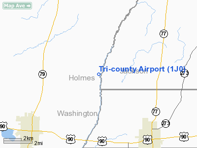
Tri-County Airport (FAA LID: 1J0) is a public-use airport located 6 miles (9.7 km) northeast of the central business district of the city of Bonifay in Holmes County, Florida, United States. The airport is publicly owned.
The above content comes from Wikipedia and is published under free licenses – click here to read more.
Location
& QuickFacts
|
FAA Information Effective: |
2007-01-18 |
|
Airport
Identifier: |
1J0 |
|
Airport
Status: |
Operational |
|
Longitude/Latitude: |
085-36-05.0000W/30-50-44.8000N
-85.601389/30.845778 (Estimated) |
|
Elevation: |
85
ft / 25.91 m (Surveyed) |
|
Land: |
300 acres |
|
From
nearest city: |
6 nautical miles NE of Bonifay, FL |
|
Location: |
Holmes County, FL |
|
Magnetic Variation: |
02W (2000) |
Owner
& Manager
|
Ownership: |
Publicly owned |
|
Owner: |
Tri County Airport Authority |
|
Address: |
Po Box 756
Bonifay, FL 32425 |
|
Phone number: |
850-547-3948 |
|
Manager: |
Jonathan Harris |
|
Address: |
3725 King Road
Caryville, FL 32427 |
|
Phone number: |
850-415-0666
FBO PHONE (850) 547-4293; PAY PHONE (850) 547-9911. |
Airport
Operations and Facilities
|
Airport Use: |
Open to public |
|
Wind
indicator: |
Yes |
|
Segmented
Circle: |
Yes |
|
Control
Tower: |
No |
|
Lighting
Schedule: |
DUSK-DAWN
MIRL RY 01/19 PRESET MED INTST - CTAF. |
|
Beacon
Color: |
Clear-Green (lighted land airport) |
|
Landing
fee charge: |
No |
|
Sectional
chart: |
New Orleans |
|
Region: |
ASO - Southern |
|
Boundary
ARTCC: |
ZJX - Jacksonville |
|
Tie-in
FSS: |
GNV - Gainesville |
|
FSS
on Airport: |
No |
|
FSS
Phone: |
850-377-3291 |
|
FSS
Toll Free: |
1-800-WX-BRIEF |
|
NOTAMs
Facility: |
GNV (NOTAM-d service avaliable) |
|
Federal Agreements: |
NGY |
Airport
Communications
|
CTAF: |
122.800 |
|
Unicom: |
122.800 |
Airport
Services
|
Fuel available: |
100LLA MOGAS |
|
Airframe Repair: |
MINOR |
|
Power Plant Repair: |
MINOR |
|
Bottled
Oxygen: |
NONE |
|
Bulk
Oxygen: |
NONE |
|
Runway Information
Runway 01/19
|
Dimension: |
4000 x 75 ft / 1219.2 x 22.9 m |
|
Surface: |
ASPH, Good Condition |
|
Weight
Limit: |
Single wheel: 30000 lbs. |
|
Edge
Lights: |
Medium |
|
|
Runway 01 |
Runway 19 |
|
Longitude: |
085-36-08.8040W |
085-36-01.1010W |
|
Latitude: |
30-50-25.3040N |
30-51-04.3350N |
|
Elevation: |
83.00
ft |
84.00
ft |
|
Alignment: |
10 |
127 |
|
Traffic
Pattern: |
Left |
Left |
|
Markings: |
Basic, Good Condition |
Basic, Good Condition |
|
VASI: |
2-light PAPI on left side |
2-light PAPI on left side |
|
Obstruction: |
44 ft trees, 1080.0 ft from runway, 20:1 slope
to clear |
40 ft trees, 1200.0 ft from runway, 200 ft
left of centerline, 25:1 slope to clear |
|
Radio Navigation
Aids
|
ID |
Type |
Name |
Ch |
Freq |
Var |
Dist |
|
BKK |
NDB |
Tri County |
|
275.00 |
02W |
0.3 nm |
|
SMY |
NDB |
Soyya |
|
329.00 |
02W |
19.5 nm |
|
OZ |
NDB |
Ruckr |
|
212.00 |
00E |
25.4 nm |
|
HYE |
NDB |
Hanchey |
|
221.00 |
00E |
31.4 nm |
|
LOR |
NDB |
Lowe |
|
269.00 |
03W |
31.8 nm |
|
BVG |
NDB |
Boll Weevil |
|
352.00 |
03E |
35.5 nm |
|
JUY |
NDB |
Judd |
|
264.00 |
02W |
49.1 nm |
|
PAM |
TACAN |
Tyndall |
124X |
|
00W |
46.4 nm |
|
FYL |
VOR |
Tri County |
|
108.40 |
08W |
0.4 nm |
|
EDN |
VOR |
Enterprise |
|
116.60 |
03W |
31.2 nm |
|
HEY |
VOR |
Hanchey |
|
110.60 |
02E |
31.9 nm |
|
UIA |
VOR |
Andalusia |
|
110.20 |
00E |
49.3 nm |
|
OZR |
VOR/DME |
Cairns |
049X |
111.20 |
02E |
26.2 nm |
|
MAI |
VORTAC |
Marianna |
087X |
114.00 |
00E |
24.9 nm |
|
RRS |
VORTAC |
Wiregrass |
053X |
111.60 |
02E |
27.8 nm |
|
PFN |
VORTAC |
Panama City |
090X |
114.30 |
00W |
38.1 nm |
Remarks
- EXTENSIVE
MILITARY HELICOPTER OPNS DALGT HRS.
- ALLIGATORS
OR DEER OCNLY ON RY.
- TREES
& BRUSH IN TRANSITION SURFACE EAST & WEST OF RY.
- RY
01 HAS BEAVER POND FIRST 500 FT W SIDE.
- VFR
OPERATIONS ONLY.
Based Aircraft
|
Aircraft
based on field: |
18 |
|
Single
Engine Airplanes: |
16 |
|
Multi
Engine Airplanes: |
2 |
Operational Statistics
Time Period: 1999-09-02
- 2000-08-31
|
Aircraft
Operations: |
78/Day |
|
Air Taxi: |
0.4% |
|
General
Aviation Local: |
4.2% |
|
General
Aviation Itinerant: |
24.9% |
|
Military: |
70.5% |
Tri-county Airport
Address:
Holmes County, FL
Tel:
850-547-3948, 850-415-0666
Images
and information placed above are from
http://www.airport-data.com/airport/1J0/
We
thank them for the data!
| General
Info |
| Country |
United
States |
| State |
FLORIDA
|
| FAA ID |
1J0
|
| Latitude |
30-50-44.800N
|
| Longitude |
085-36-05.000W
|
| Elevation |
85 feet
|
| Near City |
BONIFAY
|
We don't guarantee the information is fresh and accurate. The data may
be wrong or outdated.
For more up-to-date information please refer to other sources.
|
|


