|
 |
|
||||
|
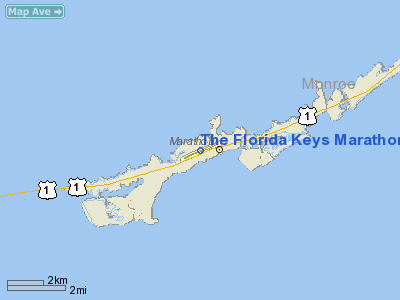
The Florida Keys Marathon Airport (IATA: MTH, ICAO: KMTH, FAA LID: MTH) is a public airport located along the Overseas Highway (US1) in Marathon, in Monroe County, Florida, United States. The airport covers 190 acres (77 ha) and has one runway. HistoryMarathon Airport was originally constructed by the United States Navy in the early 1940s as Outlying Field Marathon (OLF Marathon), an auxiliary airfield to Naval Air Station Key West. It was deactivated as a military facility at the end of World War II and transferred to the government of Monroe County for use as a civilian airport. For most of its existence, the airport has been a general aviation facility. Regional propeller service began in the 1960s with National Airlines treating it as a "flag stop." A person on the ground would "wave" a large flag as the aircraft passed overhead from Key West, if there were Marathon - Miami passengers waiting. Later, American Air Taxi (AAT Airlines) ran a limited passenger service into Marathon. In the late 1960s Southeast Airlines serviced the airport with three flights daily to and from Miami, via Key West, utilizing two Martin 4-0-4s and a Fairchild F-27. After the demise of this service, an airline founded in Key West (Air Sunshine) serviced Marathon with Douglas DC-3 aircraft to and from Miami. For a time in the early 1970s, Air Florida provided service to Marathon and Key West, followed by Provincetown-Boston Airlines (PBA) which used a combination of DC-3s and modern turboprop aircraft. Marathon Airport was served by American Eagle Airlines until 2000. In mid-2006, Delta Air Lines announced planned non-stop service to Marathon via its regional subsidiary Atlantic Southeast Airlines (ASA). Shortly after the Delta announcement, Continental Airlines announced that it would begin services to Marathon via its Florida subsidiary Gulfstream International. In July 2006, the Transportation Security Administration (TSA) notified airport officials at Marathon Airport that due to a shortage of personnel, the TSA would not be able to staff Marathon Airport with federal security screeners; passengers would have to board and disembark airline aircraft at the general aviation ramp area located on the opposite end of the runway instead of at the airport's passenger terminal. Both Continental and Delta have since stated that using this area is inconvenient to both passengers and airline staff, as it will cause lengthy delays in boarding due to all passengers having to be screened as they enter the aircraft rather than before reaching the gate. Connecting passengers will also have to be rescreened at the intermediate destination before boarding their connecting aircraft, causing further inconveniences in passenger connections; both airlines stated that if the airport cannot resolve the TSA issue before their announced service start days, they would withdraw their previously announced scheduled service offers. However on December 1, 2006, the TSA bowed to the effective lobbying efforts of local government, congressional and business officials when it announced that screeners would be provided at the airport no later than February 15, 2007, even if it meant using a contractor [1][2]. As a result of the TSA decision, ASA began daily scheduled service on February 15, 2007. In late spring of 2007, Delta began using Freedom Airlines and ended its ASA service. The reason for this switch was because Marathon's published runway length is 5,000 feet (1,500 m) and Freedom Airlines' Embraer ERJ-145 regional jet aircraft have better short field performance. When ASA serviced the airport it used special 40 seat Canadair CRJ-100 regional jets because the performance and takeoff weight of the 50-seat versions would exceed safety margins, given Marathon's comparatively short runway length. In mid summer of 2007, Delta announced it would end service to Marathon Airport due to low demand. On October 4, 2008, Continental Airlines announced it would begin commercial service to Marathon Airport via a Cape Air codeshare to Southwest Florida International Airport in Fort Myers, with TSA security clearance to occur once on the ground in Fort Myers, if connecting to another flight. Service began on December 19, 2008 but has since ended. Also in 2008, Marathon Airport was featured in Army of Two, a third person shooter video game by EA Montreal. Airlines and destinationsCharter flights
The above content comes from Wikipedia and is published under free licenses – click here to read more.
Runway InformationRunway 07/25
Radio Navigation Aids
Remarks
Based Aircraft
Operational StatisticsTime Period: 2005-06-01 - 2006-05-31
The Florida Keys Marathon Airport Address: Monroe County, FL Tel: 305-296-5439, 305-289-6060 Images
and information placed above are from We thank them for the data!
We don't guarantee the information is fresh and accurate. The data may
be wrong or outdated.
|
|||||||||||||||||||||||||||||||||||||||||||||||||||||||||||||||||||||||||||||||||||||||||||||||||||||||||||||||||||||||||||||||||||||||||||||||||||||||||||||||||||||||||||||||||||||||||||||||||||||||||||||||||||||||||||||||||||||||||||||||||||||||||||||||||||||||||||||||||||||||

 |
|
Copyright 2004-2024 © by Airports-Worldwide.com, Vyshenskoho st. 36, Lviv 79010, Ukraine Legal Disclaimer |