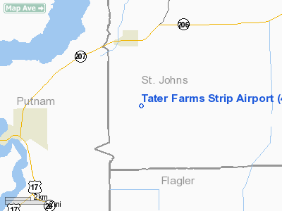
Tater Farms Strip Airport |
Location
& QuickFacts
|
FAA Information Effective: |
2007-01-18 |
|
Airport
Identifier: |
46FD |
|
Airport
Status: |
Operational |
|
Longitude/Latitude: |
081-29-50.2760W/29-40-04.8910N
-81.497299/29.668025 (Estimated) |
|
Elevation: |
14
ft / 4.27 m (Estimated) |
|
Land: |
4
acres |
|
From
nearest city: |
3 nautical miles SE of Hastings, FL |
|
Location: |
St Johns County, FL |
|
Magnetic Variation: |
04W (1990) |
Owner
& Manager
|
Ownership: |
Privately owned |
|
Owner: |
Frank C Johns Jr |
|
Address: |
6245 C.r. 13 South
Hastings, FL 32145 |
|
Phone number: |
904-692-2710 |
|
Address: |
|
Airport
Operations and Facilities
|
Airport Use: |
Private
PERSONAL USE. |
|
Wind
indicator: |
Yes |
|
Segmented
Circle: |
No |
|
Control
Tower: |
No |
|
Sectional
chart: |
Jacksonville |
|
Region: |
ASO - Southern |
|
Boundary
ARTCC: |
ZJX - Jacksonville |
|
Tie-in
FSS: |
GNV - Gainesville |
|
FSS
on Airport: |
No |
|
FSS
Phone: |
850-377-3291 |
|
FSS
Toll Free: |
1-800-WX-BRIEF |
|
Runway Information
Runway 09/27
|
Dimension: |
2400 x 65 ft / 731.5 x 19.8 m |
|
Surface: |
TURF, |
|
|
Runway 09 |
Runway 27 |
|
Traffic
Pattern: |
Left |
Left |
|
Obstruction: |
25
ft trees |
|
|
Radio Navigation
Aids
|
ID |
Type |
Name |
Ch |
Freq |
Var |
Dist |
|
IAK |
NDB |
Palatka |
|
243.00 |
05W |
16.4 nm |
|
GN |
NDB |
Wynds |
|
269.00 |
04W |
35.2 nm |
|
DED |
NDB |
Deland/dcmsnd |
|
201.00 |
05W |
37.9 nm |
|
HEG |
NDB |
Herlong |
|
332.00 |
02W |
40.0 nm |
|
EYA |
NDB |
Eastport |
|
357.00 |
03W |
45.8 nm |
|
EVB |
NDB |
New Smyrna Beach |
|
417.00 |
04W |
47.0 nm |
|
NIP |
TACAN |
Jacksonville |
19X |
|
04W |
35.3 nm |
|
NZC |
TACAN |
Cecil/dcmsnd |
088X |
|
04W |
38.5 nm |
|
NRB |
TACAN |
Mayport |
051X |
|
03W |
43.5 nm |
|
VQQ |
VOR |
Cecil |
|
117.90 |
03W |
38.6 nm |
|
SGJ |
VOR/DME |
St Augustine |
031X |
109.40 |
06W |
19.4 nm |
|
OMN |
VORTAC |
Ormond Beach |
073X |
112.60 |
00E |
29.8 nm |
|
CRG |
VORTAC |
Craig |
092X |
114.50 |
03W |
40.3 nm |
|
GNV |
VORTAC |
Gators |
109X |
116.20 |
04W |
40.5 nm |
|
OCF |
VORTAC |
Ocala |
084X |
113.70 |
00E |
48.2 nm |
|
DAB |
VOT |
Daytona Beach |
|
111.00 |
|
37.3 nm |
Remarks
- 25
FT PLINES SOUTH SIDE OF RY 09/27.
- PERSONAL
USE; ALL TFC PATTERNS AND OPERATIONS CONDUCTED SOUTH OF RY AND RY CNTRLN
EXTDD.
Tater Farms Strip Airport
Address:
St Johns County, FL
Tel:
904-692-2710
Images
and information placed above are from
http://www.airport-data.com/airport/46FD/
We
thank them for the data!
| General
Info |
| Country |
United
States |
| State |
FLORIDA
|
| FAA ID |
46FD
|
| Latitude |
29-40-04.891N
|
| Longitude |
081-29-50.276W
|
| Elevation |
14 feet
|
| Near City |
HASTINGS
|
We don't guarantee the information is fresh and accurate. The data may
be wrong or outdated.
For more up-to-date information please refer to other sources.
|


