 |
|
Tallahassee Regional Airport |
| Tallahassee Regional Airport |
| IATA: TLH – ICAO: KTLH – FAA LID: TLH |
| Summary |
| Airport type |
Public |
| Owner |
City of Tallahassee |
| Serves |
Tallahassee, Florida |
| Elevation AMSL |
81 ft / 25 m |
| Coordinates |
30°23′48″N 084°21′01″W / 30.39667°N 84.35028°W / 30.39667; -84.35028 |
| Website |
www.talgov.com/... |
| Runways |
| Direction |
Length |
Surface |
| ft |
m |
| 9/27 |
8,000 |
2,438 |
Asphalt |
| 18/36 |
6,076 |
1,852 |
Asphalt |
| Statistics (2007) |
| Aircraft operations |
100,420 |
| Based aircraft |
136 |
| Passengers (2006) |
988,433 |
| Source: Federal Aviation Administration |
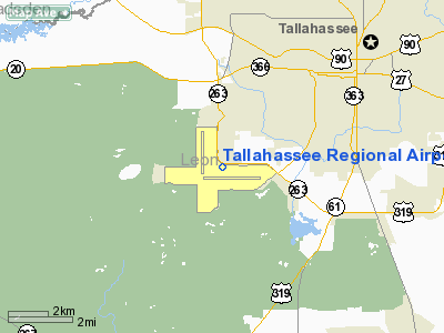
Tallahassee Regional Airport (IATA: TLH, ICAO: KTLH, FAA LID: TLH) is a city-owned public-use airport located four nautical miles (7 km) southwest of the central business district of Tallahassee, a city in Leon County, Florida, United States. History
Tallahassee Regional Airport began operation as Tallahassee Municipal Airport with a dedication on April 23, 1961. The flag of the United States was presented to the City of Tallahassee by Captain Eddie Rickenbacker, World War I fighter ace and Chairman of the Board of Eastern Airlines. An aerial demonstration was performed by U.S. Army aircraft from Fort Rucker, Alabama. Tallahassee Municipal replaced Dale Mabry Field which closed that same year.
 | |
City Commission at airport (1961) |
Eastern Airlines inaugurated the opening of the airport by ferrying city, state and chamber of commerce officials. Aboard the flight were: Tallahassee Mayor Joe Cordell, State Comptroller Ray Green, Tallahassee City Commissioners Davis Atkinson, George Taff, Hugh Williams, Tallahassee City Manager Arvah Hopkins, Tallahasee City Clerk-Auditor George White, Airport Manager Flagg Chittenden, and Ernest Menendez, Frank Deller, James Calhoun, John Ward and Jeff Lewis, all of the Tallahassee/Leon County Chamber of Commerce.
Standing from left to right: James Messer, Jr., Edward Hill, John A. Rudd, George C. White, and Arvah B. Hopkins.
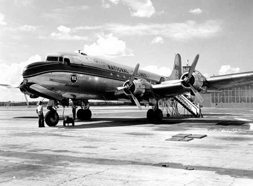
During the 1960s, 70s and early 1980s, the airport's primary runway was Runway 18/36, a 6076 foot runway with an FAA certified ILS approach, enabling all weather approaches by airliners and civilian aircraft, and a USAF certified High TACAN approach for practice use by Air Force aircraft at nearby Tyndall AFB. An additional runway, Runway 9/27, was 4000 feet and length and supported general aviation operations. By the 1970s, the airport had regular scheduled commercial service from Eastern Airlines, Delta Air Lines, National Airlines and Southern Airways, primarily using Boeing 727, Boeing 737 and McDonnell Douglas DC-9 aircraft.
By the 1980s, the existing terminal was becoming increasingly obsolete and the 6100 foot main runway was considered less than optimal for the Boeing 757 and Boeing 767 coming into service. The existing Runway 9/27 was converted to taxiway and a new Runway 9/27 that was 8000 feet in length and equipped with ILS was constructed immediately to the south. Concurrently, a new passenger terminal was constructed just north of the new runway. On December 3, 1989, the city opened the existing $33 million, airline passenger terminal, and on February 20, 2000, the passenger terminal was officially renamed the Ivan Munroe Terminal in honor of Tallahassee aviation pioneer Ivan Munroe. Munroe was the first man in Tallahassee to own a plane.
On July 20, 2002, A FedEx Boeing 727 crashed a half mile short of the runway 9 while attempting to land. The NTSB determined that the crash was due to a combination of pilot fatigue and pilot error.
With the recent addition of slots at Washington National Airport for US Airways, that airline will be starting nonstop flights to Tallahassee from Washington Reagan Airport. The actual start date has yet to be announced.
Terminal Building
The FAA and the Florida Department of Transportation (FDOT) will possibly allocate a $7.2 million dollars of a grant fund to be put toward planned airport improvements, such as the Ivan Munroe Terminal and the rehabilition of the north gerneral aviation apron. Other future projects include the Fast Track program, to include the widening of the Capital Circle Southwest entry and exit road to airport, internal road network, airport maintenance complex and security improvements. Door replacements and roof repairs are also anticipated to follow.
Facilities and aircraft
Tallahassee Regional Airport covers an area of 2,490 acres (1,008 ha) at an elevation of 81 feet (25 m) above mean sea level. It has two runways: 9/27 measuring 8,000 by 150 feet (2,438 by 46 m) and 18/36 measuring 6,076 by 150 ft. (1,852 by 46 m). Helicopter operations are generally confined to the Runway 18/36 area, or direct approaches to the Eagle FBO ramp area.
For the 12-month period ending May 31, 2007, the airport had 100,420 aircraft operations, an average of 275 per day: 51% general aviation, 29% air taxi, 15% military and 4% scheduled commercial. At that time there were 136 aircraft based at this airport: 76% single-engine, 14% multi-engine, 2% jet and 7% helicopter.
Airlines and destinations
The Tallahassee Regional Airport terminal consists of two concourses (A and B).
| Airlines |
Destinations |
Concourse |
| American Eagle |
Dallas/Fort Worth, Miami |
A |
| Continental Connection operated by Gulfstream International Airlines |
Fort Lauderdale, Orlando, Tampa, West Palm Beach |
A |
| Delta Air Lines |
Atlanta |
B |
| Delta Connection operated by Atlantic Southeast Airlines |
Atlanta, Fort Lauderdale, Memphis |
B |
| Delta Connection operated by Pinnacle Airlines |
Memphis |
B |
| Delta Connection operated by Shuttle America |
Memphis |
B |
| US Airways Express operated by PSA Airlines |
Charlotte |
A |
| US Airways Express operated by Mesa Airlines |
Charlotte |
A |
The above content comes from Wikipedia and is published under free licenses – click here to read more.
Location
& QuickFacts
|
FAA Information Effective: |
2007-01-18 |
|
Airport
Identifier: |
TLH |
|
Airport
Status: |
Operational |
|
Longitude/Latitude: |
084-21-01.2000W/30-23-47.5000N
-84.350333/30.396528 (Estimated) |
|
Elevation: |
81
ft / 24.69 m (Surveyed) |
|
Land: |
2490 acres |
|
From
nearest city: |
4 nautical miles SW of Tallahassee, FL |
|
Location: |
Leon County, FL |
|
Magnetic Variation: |
03W (2000) |
Owner
& Manager
|
Ownership: |
Publicly owned |
|
Owner: |
City Of Tallahassee |
|
Address: |
City Hall
Tallahassee, FL 32304 |
|
Phone
number: |
850-891-7802 |
|
Manager: |
Kenneth M. Austin |
|
Address: |
3300 Capitol Circle Sw
Tallahassee, FL 32310 |
|
Phone number: |
850-891-7802 |
Airport
Operations and Facilities
|
Airport Use: |
Open to public |
|
Wind
indicator: |
Yes |
|
Segmented
Circle: |
Yes |
|
Control
Tower: |
Yes |
|
Lighting
Schedule: |
DUSK-DAWN
WHEN ATCT CLSD ACTVT HIRL RYS 09/27 & 18/36, PAPI RYS
09, 27, 18 & 36, MALSR 36 AND REIL RYS 09 & 18 -
CTAF. ALSF2
RY 27 PRESET ON MED INTST. |
|
Beacon
Color: |
Clear-Green (lighted land airport) |
|
Landing
fee charge: |
No |
|
Sectional
chart: |
Jacksonville |
|
Region: |
ASO - Southern |
|
Boundary
ARTCC: |
ZJX - Jacksonville |
|
Tie-in
FSS: |
GNV - Gainesville |
|
FSS
on Airport: |
No |
|
FSS
Phone: |
850-377-3291 |
|
FSS
Toll Free: |
1-800-WX-BRIEF |
|
NOTAMs
Facility: |
TLH (NOTAM-d service avaliable) |
|
Certification type/date: |
I C S 05/1973 |
|
Federal Agreements: |
NGSY |
Airport
Communications
|
CTAF: |
118.700 |
|
Unicom: |
122.950 |
Airport
Services
|
Fuel available: |
100LLA |
|
Airframe Repair: |
MAJOR |
|
Power Plant Repair: |
MAJOR |
|
Bottled
Oxygen: |
HIGH |
|
Bulk
Oxygen: |
HIGH |
|
Runway Information
Runway 09/27
|
Dimension: |
8000 x 150 ft / 2438.4 x 45.7 m |
|
Surface: |
ASPH, Good Condition |
|
Surface
Treatment: |
Saw-cut or plastic Grooved |
|
Weight
Limit: |
Single wheel: 115000 lbs.
Dual wheel: 170000 lbs.
Dual
tandem wheel: 330000 lbs. |
|
Edge
Lights: |
High |
|
|
Runway 09 |
Runway 27 |
|
Longitude: |
084-21-23.5529W |
084-19-52.2177W |
|
Latitude: |
30-23-28.7146N |
30-23-29.4394N |
|
Elevation: |
61.00
ft |
49.00
ft |
|
Alignment: |
89 |
127 |
|
ILS
Type: |
|
ILS |
|
Traffic
Pattern: |
Left |
Left |
|
Markings: |
Precision instrument, Good Condition |
Precision instrument, Good Condition |
|
Crossing
Height: |
57.00
ft |
55.00
ft |
|
VASI: |
4-light PAPI on left side |
4-light PAPI on left side |
|
Visual
Glide Angle: |
3.00� |
3.00� |
|
RVR
Equipment: |
touchdown |
touchdown |
|
Approach
lights: |
|
ALSF2 |
|
Runway
End Identifier: |
Yes |
|
|
Centerline
Lights: |
Yes |
Yes |
|
Touchdown
Lights: |
|
Yes |
|
Runway 18/36
|
Dimension: |
6076 x 150 ft / 1852.0 x 45.7 m |
|
Surface: |
ASPH, Good Condition |
|
Surface
Treatment: |
Saw-cut or plastic Grooved |
|
Weight
Limit: |
Single wheel: 115000 lbs.
Dual wheel: 170000 lbs.
Dual
tandem wheel: 330000 lbs. |
|
Edge
Lights: |
High |
|
|
Runway 18 |
Runway 36 |
|
Longitude: |
084-21-32.3064W |
084-21-31.6846W |
|
Latitude: |
30-24-41.8360N |
30-23-41.7001N |
|
Elevation: |
81.00
ft |
58.00
ft |
|
Alignment: |
127 |
127 |
|
ILS
Type: |
|
ILS |
|
Traffic
Pattern: |
Left |
Left |
|
Markings: |
Precision instrument, Fair Condition |
Precision instrument, Good Condition |
|
Crossing
Height: |
46.00
ft |
0.00 ft |
|
VASI: |
4-light PAPI on left side |
4-light PAPI on left side |
|
Visual
Glide Angle: |
3.00� |
0.00� |
|
RVR
Equipment: |
|
touchdown |
|
Approach
lights: |
|
MALSR |
|
Runway
End Identifier: |
Yes |
|
|
Obstruction: |
47 ft tree, 2600.0 ft from runway, 500 ft right
of centerline, 40:1 slope to clear |
, 50:1 slope to clear |
|
Radio Navigation
Aids
|
ID |
Type |
Name |
Ch |
Freq |
Var |
Dist |
|
TL |
NDB |
Wakul |
|
379.00 |
01W |
4.2 nm |
|
CYR |
NDB |
Caidy |
|
338.00 |
01W |
31.2 nm |
|
LYZ |
NDB |
Willis |
|
359.00 |
01W |
35.8 nm |
|
GTP |
NDB |
Patten |
|
245.00 |
02W |
43.2 nm |
|
FPY |
NDB |
Foley |
|
254.00 |
03W |
46.4 nm |
|
CXU |
NDB |
Camilla |
|
369.00 |
02W |
49.5 nm |
|
MGR |
VOR/DME |
Moultrie |
025X |
108.80 |
02W |
49.9 nm |
|
SZW |
VORTAC |
Seminole |
122X |
117.50 |
02E |
9.7 nm |
|
GEF |
VORTAC |
Greenville |
027X |
109.00 |
01E |
30.8 nm |
|
MAI |
VORTAC |
Marianna |
087X |
114.00 |
00E |
46.4 nm |
|
TLH |
VOT |
Tallahassee Muni |
|
111.00 |
|
0.3 nm |
Remarks
- PROFILE
OF RY 09/27 RESTRICTS VISIBILITY FROM THR OF 09 TO THR OF 27.
- MOVEMENT
AREA OF TWY 'Z' BEGINS AT THE INTXN OF TWY 'J' & PROCEEDS E TO THE
INTXN OF TWY 'K' THIS TWY IS NOT FOR USE BY ACR OPNS; ASPH BTN TWYS
'J' & 'M' IS FOR HEL OPNS; TWY 'Z' FM TWY 'M' TO THE RAMP IS OPEN
TO ACFT WITH WINGSPAN OF 50 FT OR LESS.
- BIRDS
ON & INVOF ARPT.
Based
Aircraft
|
Aircraft
based on field: |
138 |
|
Single
Engine Airplanes: |
101 |
|
Multi
Engine Airplanes: |
23 |
|
Jet Engine
Airplanes: |
4 |
|
Helicopters: |
10 |
Major Carriers
Serving This Airport
| Delta Air Lines Inc. |
47.1% |
| Expressjet Airlines Inc. |
28.2% |
| Atlantic Southeast Airlines |
19.2% |
| Comair Inc. |
5.5% |
Most Popular Destinations
|
Hartsfield - Jackson Atlanta Intl (ATL) |
59.7% |
|
George Bush Intercontinental/houston (IAH) |
28.2% |
|
Cincinnati/northern Kentucky Intl (CVG) |
9.7% |
| Orlando Intl (MCO) |
2.5% |
Most Popular Aircraft
|
N14522 |
2.2% |
| N14516 |
2.2% |
|
N15527 |
2.1% |
| N11526 |
2.0% |
|
N16520 |
1.8% |
| N14514 |
1.7% |
|
N12530 |
1.7% |
| N16525 |
1.5% |
|
N24517 |
1.3% |
| N28529 |
1.3% |
Operational Statistics
Time Period: 2005-04-01
- 2006-03-31
|
Aircraft
Operations: |
265/Day |
|
Commerical: |
6.4% |
|
Air Taxi: |
29.6% |
|
General
Aviation Local: |
13.6% |
|
General
Aviation Itinerant: |
39.2% |
|
Military: |
11.1% |
Tallahassee Regional Airport
Address:
Leon County, FL
Tel:
850-891-7802
Images
and information placed above are from
http://www.airport-data.com/airport/TLH/
We
thank them for the data!
| General
Info |
| Country |
United
States |
| State |
FLORIDA
|
| FAA ID |
TLH
|
| Latitude |
30-23-47.500N
|
| Longitude |
084-21-01.200W
|
| Elevation |
81 feet
|
| Near City |
TALLAHASSEE
|
We don't guarantee the information is fresh and accurate. The data may
be wrong or outdated.
For more up-to-date information please refer to other sources.
|
|


