 |
|
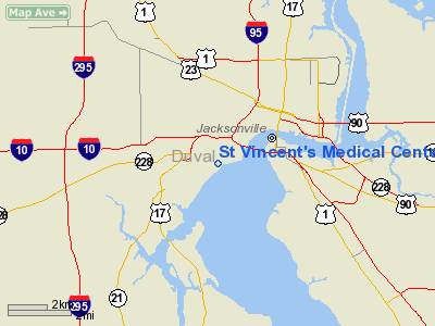
St. Vincent's Medical Center Heliport |
|
|
Location
& QuickFacts
|
FAA Information Effective: |
2007-01-18 |
|
Airport
Identifier: |
35FL |
|
Airport
Status: |
Operational |
|
Longitude/Latitude: |
081-41-23.3470W/30-18-31.8610N
-81.689819/30.308850 (Estimated) |
|
Elevation: |
63
ft / 19.20 m (Estimated) |
|
Land: |
0
acres |
|
From
nearest city: |
2 nautical miles SW of Jacksonville, FL |
|
Location: |
Duval County, FL |
|
Magnetic Variation: |
04W (1990) |
Owner
& Manager
|
Ownership: |
Privately owned |
|
Owner: |
St Vincent's Mecical Center |
|
Address: |
1800 Barrs St
Jacksonville, FL 32204 |
|
Phone number: |
904-387-7400 |
|
Manager: |
Jack A. Mc Herron |
|
Address: |
1800 Barrs St
Jacksonville, FL 32204 |
|
Phone number: |
904-387-7400 |
Airport
Operations and Facilities
|
Airport Use: |
Private |
|
Wind
indicator: |
Yes |
|
Segmented
Circle: |
No |
|
Control
Tower: |
No |
|
Lighting
Schedule: |
PHONE REQ
FOR ROTG BCN & PERIMETER LGTS CALL 904-387-7400. |
|
Beacon
Color: |
Clear-Green-Yellow (heliport) |
|
Sectional
chart: |
Jacksonville |
|
Region: |
ASO - Southern |
|
Boundary
ARTCC: |
ZJX - Jacksonville |
|
Tie-in
FSS: |
GNV - Gainesville |
|
FSS
Phone: |
850-377-3291 |
|
FSS
Toll Free: |
1-800-WX-BRIEF |
|
Runway Information
Helipad H1
|
Dimension: |
96 x 87 ft / 29.3 x 26.5 m |
|
Surface: |
CONC, |
|
|
Runway H1 |
Runway |
|
Traffic
Pattern: |
Left |
Left |
|
Radio Navigation
Aids
|
ID |
Type |
Name |
Ch |
Freq |
Var |
Dist |
|
HEG |
NDB |
Herlong |
|
332.00 |
02W |
6.5 nm |
|
EYA |
NDB |
Eastport |
|
357.00 |
03W |
8.1 nm |
|
JA |
NDB |
Dinns |
|
344.00 |
03W |
11.0 nm |
|
IAK |
NDB |
Palatka |
|
243.00 |
05W |
39.9 nm |
|
GN |
NDB |
Wynds |
|
269.00 |
04W |
45.9 nm |
|
LCQ |
NDB |
Lake City |
|
204.00 |
03W |
46.7 nm |
|
NIP |
TACAN |
Jacksonville |
19X |
|
04W |
4.5 nm |
|
NZC |
TACAN |
Cecil/dcmsnd |
088X |
|
04W |
10.8 nm |
|
NRB |
TACAN |
Mayport |
051X |
|
03W |
14.6 nm |
|
VQQ |
VOR |
Cecil |
|
117.90 |
03W |
11.9 nm |
|
SGJ |
VOR/DME |
St Augustine |
031X |
109.40 |
06W |
28.2 nm |
|
CRG |
VORTAC |
Craig |
092X |
114.50 |
03W |
9.5 nm |
|
TAY |
VORTAC |
Taylor |
076X |
112.90 |
03W |
46.3 nm |
|
SSI |
VORTAC |
Brunswick |
035X |
109.80 |
04W |
46.3 nm |
|
GNV |
VORTAC |
Gators |
109X |
116.20 |
04W |
47.9 nm |
|
JAX |
VOT |
Jacksonville Intl |
|
111.00 |
|
11.1 nm |
Remarks
- APCH/DEP
290 DEG CLKWS TO 080 DEG WITH PAD BEING CNTR OF COMPASS ROSE.
St Vincent's Medical Center Heliport
Address:
Duval County, FL
Tel:
904-387-7400
Images
and information placed above are from
http://www.airport-data.com/airport/35FL/
We
thank them for the data!
| General
Info |
| Country |
United
States |
| State |
FLORIDA
|
| FAA ID |
35FL
|
| Latitude |
30-18-31.861N
|
| Longitude |
081-41-23.347W
|
| Elevation |
63 feet
|
| Near City |
JACKSONVILLE
|
We don't guarantee the information is fresh and accurate. The data may
be wrong or outdated.
For more up-to-date information please refer to other sources.
|
|


