 |
|
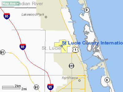
St. Lucie County International Airport |
| St. Lucie County International Airport |
| IATA: FPR – ICAO: KFPR – FAA LID: FPR |
| Summary |
| Airport type |
Public |
| Owner |
St. Lucie Board of County Commissioners |
| Location |
Fort Pierce, Florida |
| Elevation AMSL |
24 ft / 7.3 m |
| Coordinates |
27°29′42″N 080°22′06″W / 27.495°N 80.36833°W / 27.495; -80.36833 |
| Website |
StLucieCo.gov/airport/ |
| Runways |
| Direction |
Length |
Surface |
| ft |
m |
| 10R/28L |
6,492 |
1,979 |
Asphalt |
| 14/32 |
4,755 |
1,449 |
Asphalt |
| 10L/28R |
4,000 |
1,219 |
Asphalt |
| Statistics (2009) |
| Aircraft operations |
avg 537/Day |
| Based aircraft |
186 |
| Source: Federal Aviation Administration |
KFPR December 1, 2009. St. Lucie County International Airport (IATA: FPR, ICAO: KFPR, FAA LID: FPR) is a public airport located three miles (5 km) northwest of the central business district of Fort Pierce, a city in St. Lucie County, Florida, United States. It is owned by the St. Lucie Board of County Commissioners.
The airport sees frequent use by various aviation flight schools in south Florida, including three based at the airport, for general aviation flight training traffic. The airport also hosts a Federal Inspection Station (FIS) administered by United States Customs & Border Patrol, which makes it a frequent stop for private aircraft coming in and out of the Bahama Islands.
DayJet provided an on-demand jet air taxi service from this airport before they suspended operation in September 2008.
That history of the airport dates back to 1921 when The Commercial Club of Fort Pierce built an airport where the local American Legion building now stands on U.S. Route 1 for an airline that never got off the ground. Nine years later, the county purchased 1,600 acres of land that eventually became the current airport; however the first commercial airport was dedicated in 1935 in an area in the vicinity of U.S. Route 1 and Edwards Road.
The current airport, originally named Fort Pierce Airport, was leased during World War II by the U.S. Navy as an auxiliary field for pilots and flight crews from Naval Air Station Vero Beach, Naval Air Station Melbourne and Naval Air Station Fort Lauderdale for conducting daytime and nighttime field carrier landing practice (FCLP) prior to landing on actual aircraft carriers. Scout aircraft, dive bombers and torpedo attack bombers utilized the runways, which were redesigned by the military to better accommodate naval aviation training requirements. In 1947, the Navy disestablished operations and the U.S. Government conveyed the airport back to the county, to include two newly constructed runways, without charging for the improvements made.
With little financial capital in county government to operate and maintain a modern airport, the facility languished for the next ten years, becoming overgrown with vegetation and subject to frequent grazing by cattle from nearby farms and ranches. During the 1960s and 1970s, major improvements took off with the construction of an airport terminal, modern hangars, airfield lighting, navigational aids and fuel facilities. Curtis King, who became the first full-time director in 1967, played an instrumental role in the development of the county's airport for 31 years.
The airport continued to evolve as a general aviation facility, and even though two of four runways were decommissioned, one such former runway became the site of the Airport West Commerce Park, while Runway 9/27 was lengthened and improved.
Runway 10L-28R was completed early 2010 costing $15.3 million dollars, the runway currently has no taxiways to parking therefore making it designated for touch and go operations. Facilities and aircraft
St. Lucie County International Airport covers an area of 3,800 acres (1,538 ha) which contains three asphalt paved runways: 10R/28L measuring 6,492 x 150 ft (1,979 x 46 m), 10L/28R measuring 4,000 x 75 ft (1,219 x 23 m) and 14/32 measuring 4,755 x 100 ft (1,449 x 30 m).
For the 12-month period ending January 15, 2009, the airport had 196,000 general aviation aircraft operations, an average of 537 per day. There are 186 aircraft based at this airport: 68% single-engine, 27% multi-engine, 3% jet and 3% helicopter. 53% of movements are local general aviation and 47% are transient general aviation.
Accidents and incidents
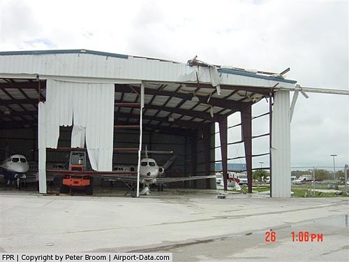
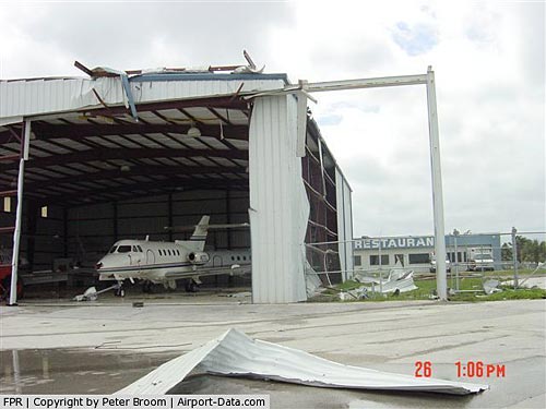
- On 5 November 2009, Grumman Albatross N120FB of Albatross Adventures crashed when an engine failed shortly after take-off. The aircraft was damaged beyond economic repair.
The above content comes from Wikipedia and is published under free licenses – click here to read more.
|
 |
(Click on the photo to enlarge) |
|
 |
(Click on the photo to enlarge) |
Location
& QuickFacts
|
FAA Information Effective: |
2007-01-18 |
|
Airport Identifier: |
FPR |
|
Airport Status: |
Operational |
|
Longitude/Latitude: |
080-22-05.8000W/27-29-42.2000N
-80.368278/27.495056 (Estimated) |
|
Elevation: |
23 ft / 7.01 m (Surveyed) |
|
Land: |
3800 acres |
|
From nearest city: |
3 nautical miles NW of Fort Pierce, FL |
|
Location: |
St Lucie County, FL |
|
Magnetic Variation: |
04W (1990) |
Owner
& Manager
|
Ownership: |
Publicly owned |
|
Owner: |
St Lucie Board Of Cnty Cmsnr |
|
Address: |
2300 Virginia Ave
Ft Pierce, FL 34982-5652 |
|
Phone
number: |
772-462-1732 |
|
Manager: |
Barbara Churchill |
|
Address: |
3000 Curtis King Blvd
Ft Pierce, FL 34946 |
|
Phone number: |
772-462-1732 |
Airport
Operations and Facilities
|
Airport Use: |
Open to public |
|
Wind
indicator: |
Yes |
|
Segmented
Circle: |
Yes |
|
Control
Tower: |
Yes |
|
Lighting
Schedule: |
DUSK-DAWN
ACTVT REIL RY 09 - CTAF. VASI RYS 09 & 27 OPERATE CONTINUOUSLY. |
|
Beacon
Color: |
Clear-Green (lighted land airport) |
|
Landing
fee charge: |
No |
|
Sectional
chart: |
Miami |
|
Region: |
ASO - Southern |
|
Boundary
ARTCC: |
ZMA - Miami |
|
Tie-in
FSS: |
MIA - Miami |
|
FSS
on Airport: |
No |
|
FSS
Phone: |
305-233-2600 |
|
FSS
Toll Free: |
1-800-WX-BRIEF |
|
NOTAMs
Facility: |
FPR (NOTAM-d service avaliable) |
|
Federal Agreements: |
NGY3 |
Airport
Communications
Airport
Services
|
Fuel available: |
100LLA |
|
Airframe Repair: |
MAJOR |
|
Power Plant Repair: |
MAJOR |
|
Bottled
Oxygen: |
NONE |
|
Bulk
Oxygen: |
NONE |
|
Runway Information
Runway 09/27
|
Dimension: |
6492
x 150 ft / 1978.8 x 45.7 m
25' PAVED SHOULDERS.
50'
PAVED SHOULDERS. |
|
Surface: |
ASPH, Good Condition
RY 14/32 HAS 50 FT PAVED SHOULDERS. |
|
Weight
Limit: |
Single wheel: 30000 lbs.
Dual wheel: 60000 lbs. |
|
Edge
Lights: |
Medium |
|
|
Runway 09 |
Runway 27 |
|
Longitude: |
080-22-45.7520W |
080-21-33.6700W |
|
Latitude: |
27-29-50.1160N |
27-29-49.5930N |
|
Elevation: |
23.00 ft |
21.00 ft |
|
Alignment: |
90 |
127 |
|
ILS
Type: |
ILS/DME |
|
|
Traffic
Pattern: |
Left |
Left |
|
Markings: |
Precision instrument, Good Condition |
Precision instrument, Good Condition |
|
Crossing
Height: |
31.00
ft |
52.00
ft |
|
VASI: |
4-box on left side |
4-box on left side |
|
Visual
Glide Angle: |
3.00� |
3.00� |
|
Runway
End Identifier: |
Yes |
|
|
Obstruction: |
75 ft pline, 3200.0 ft from runway, 40:1 slope
to clear |
22 ft trees, 1230.0 ft from runway, 46:1 slope
to clear |
|
Runway 14/32
|
Dimension: |
4756
x 100 ft / 1449.6 x 30.5 m
25' PAVED SHOULDERS.
50'
PAVED SHOULDERS. |
|
Surface: |
ASPH, Good Condition
RY 14/32 HAS 50 FT PAVED SHOULDERS. |
|
Weight
Limit: |
Single wheel: 15000 lbs. |
|
Edge
Lights: |
Medium |
|
|
Runway 14 |
Runway 32 |
|
Longitude: |
080-22-18.9310W |
080-21-41.8980W |
|
Latitude: |
27-29-48.5170N |
27-29-14.9400N |
|
Elevation: |
22.00 ft |
23.00 ft |
|
Alignment: |
127 |
127 |
|
Traffic
Pattern: |
Left |
Left |
|
Markings: |
Non-precision instrument, Fair Condition |
Non-precision instrument, Fair Condition |
|
Obstruction: |
33 ft trees, 1300.0 ft from runway, 34:1 slope
to clear |
27 ft pline, 1323.0 ft from runway, 41:1 slope
to clear |
|
Radio Navigation
Aids
|
ID |
Type |
Name |
Ch |
Freq |
Var |
Dist |
|
FPR |
NDB |
Fort Pierce |
|
275.00 |
04W |
0.6 nm |
|
VEP |
NDB |
Vero Beach |
|
392.00 |
04W |
10.5 nm |
|
UTX |
NDB |
United |
|
405.00 |
03W |
35.3 nm |
|
SQT |
NDB |
Satellite |
|
257.00 |
03W |
40.4 nm |
|
PB |
NDB |
Rubin |
|
356.00 |
03W |
49.3 nm |
|
COF |
TACAN |
Patrick |
097X |
|
04W |
46.5 nm |
|
MLB |
VOR/DME |
Melbourne |
037X |
110.00 |
02W |
39.3 nm |
|
VRB |
VORTAC |
Vero Beach |
120X |
117.30 |
04W |
12.8 nm |
|
PHK |
VORTAC |
Pahokee |
101X |
115.40 |
00E |
46.2 nm |
|
VRB |
VOT |
Vero Beach |
|
111.00 |
|
9.9 nm |
Remarks
- 8
FT FENCE 400 FT FM CNTRLN ON NORTH SIDE OF RY 09/27 AND EAST OF RY 14/32.
- VOLUNTARY
RESTRICTIONS ON TOUCH AND GO OR STOP AND GO OPERATIONS ON SUN, HOLIDAYS,
AND MON-SAT 2 HRS AFTER SS-1300Z++
- EXTREMELY
NOISE SENSITIVE AREA E & SE. WHEN ATCT CLSD RIGHT TFC RY 14. FOR
ADDITIONAL NOISE ABATEMENT PROCS CTC ARPT 772-462-1732.
- EXTENSIVE
FLIGHT TRAINING ON AND WITHIN 20 MILES OF ARPT BLO 6000 FT. VFR TRAINING
ACFT OUTSIDE OF CLASS D AIRSPACE TRANSMIT INTENDED ACTIVITY ON 123.3.
- TWY
SIGNS & LGTS UNRELBL.
- NUMEROUS
FLOCKS OF BIRDS & WILDLIFE ON AND INVOF ARPT.
- TREES
ON AER 09 600 FT FM R & L OF CNTRLN.
- TWY
C1 RESTRICTED TO ACFT WITH A WING SPAN OF 105 FT OR LESS.
Based
Aircraft
|
Aircraft
based on field: |
185 |
|
Single
Engine Airplanes: |
125 |
|
Multi
Engine Airplanes: |
50 |
|
Jet Engine
Airplanes: |
5 |
|
Helicopters: |
5 |
Operational
Statistics
Time Period:
1998-07-15 - 1999-07-14
|
Aircraft
Operations: |
537/Day |
|
General
Aviation Local: |
53.0% |
|
General
Aviation Itinerant: |
47.0% |
St Lucie County International Airport
Address:
St Lucie County, FL
Tel:
772-462-1732
Images
and information placed above are from
http://www.airport-data.com/airport/FPR/
We
thank them for the data!
| General
Info |
| Country |
United
States |
| State |
FLORIDA
|
| FAA ID |
FPR
|
| Latitude |
27-29-42.200N
|
| Longitude |
080-22-05.800W
|
| Elevation |
23 feet
|
| Near City |
FORT PIERCE
|
We don't guarantee the information is fresh and accurate. The data may
be wrong or outdated.
For more up-to-date information please refer to other sources.
|
|


