 |
|
| Naval Outlying Field Spencer |
| IATA: none – ICAO: KNRQ – FAA LID: NRQ |
| Summary |
| Airport type |
Military |
| Owner |
US Navy |
| Location |
Santa Rosa County, near Pace, Florida |
| Elevation AMSL |
151 ft / 46 m |
| Coordinates |
30°37′30″N 087°08′24″W / 30.625°N 87.14°W / 30.625; -87.14 |
| Runways |
| Direction |
Length |
Surface |
| ft |
m |
| 4L/22R |
1,800 |
549 |
Asphalt |
| 4R/22L |
1,800 |
549 |
Asphalt |
| 9L/27R |
1,800 |
549 |
Asphalt |
| 9R/27L |
1,800 |
549 |
Asphalt |
| 13L/31R |
1,800 |
549 |
Asphalt |
| 13R/31L |
1,800 |
549 |
Asphalt |
| 18L/36R |
1,800 |
549 |
Asphalt |
| 18R/36L |
1,800 |
549 |
Asphalt |
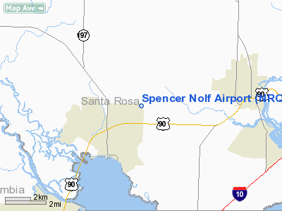
Naval Outlying Field Spencer (ICAO: KNRQ, FAA LID: NRQ) is a military airport located two miles (3 km) northeast of Pace, Florida, in Santa Rosa County. It is owned by the United States Navy. NOLF Spencer is one mile north of U.S. Highway 90, 3.5 miles west of the City of Milton, just over 6 miles east of the Escambia River and about 7 miles southwest of NAS Whiting Field. This airfield is situated on 640 acres (259 ha) and has eight runways, all 1800 feet long by 200 feet wide. These runways are arranged to make two squares, one whose vertices approximately point North, South, East and West, and another which lies directly on top but is rotated 45°. Its mission is to support helicopter operations of the Naval Air Training Command.
Although most U.S. airports use the same three-letter location identifier for the FAA and IATA, Naval Outlying Field Spencer is assigned NRQ by the FAA but has no designation from the IATA.
The above content comes from Wikipedia and is published under free licenses – click here to read more.
Location
& QuickFacts
|
FAA Information Effective: |
2007-01-18 |
|
Airport
Identifier: |
NRQ |
|
Airport
Status: |
Operational |
|
Longitude/Latitude: |
087-08-00.0000W/30-37-00.0000N
-87.133333/30.616667 (Estimated) |
|
Elevation: |
151 ft / 46.02 m (Estimated) |
|
Land: |
0
acres |
|
From
nearest city: |
2 nautical miles NE of Pace, FL |
|
Location: |
Santa Rosa County, FL |
|
Magnetic Variation: |
00W (1995) |
Owner
& Manager
|
Ownership: |
Navy owned |
|
Owner: |
Us Navy |
|
Address: |
Oceanographic Ofc - Code 3142
Washington, DC 20373 |
|
Manager: |
Us Navy |
|
Address: |
Operations Duty Officer, Naval Air Station
Whiting Field
Milton, FL 32570 |
|
Phone number: |
DSN-868-7598 |
Airport
Operations and Facilities
|
Airport Use: |
Private |
|
Segmented
Circle: |
No |
|
Control
Tower: |
No |
|
Sectional
chart: |
New Orleans |
|
Region: |
ASO - Southern |
|
Boundary
ARTCC: |
ZJX - Jacksonville |
|
Tie-in
FSS: |
GNV - Gainesville |
|
FSS
Phone: |
850-377-3291 |
|
FSS
Toll Free: |
1-800-WX-BRIEF |
|
Runway Information
Runway 04L/22R
|
Dimension: |
1800 x 150 ft / 548.6 x 45.7 m |
|
Surface: |
ASPH, |
|
|
Runway 04L |
Runway 22R |
|
Traffic
Pattern: |
Left |
Left |
|
Runway 04R/22L
|
Dimension: |
1800 x 150 ft / 548.6 x 45.7 m |
|
Surface: |
ASPH, |
|
|
Runway 04R |
Runway 22L |
|
Traffic
Pattern: |
Left |
Left |
|
Runway 09L/27R
|
Dimension: |
1800 x 150 ft / 548.6 x 45.7 m |
|
Surface: |
ASPH, |
|
|
Runway 09L |
Runway 27R |
|
Traffic
Pattern: |
Left |
Left |
|
Runway 09R/27L
|
Dimension: |
1800 x 150 ft / 548.6 x 45.7 m |
|
Surface: |
ASPH, |
|
|
Runway 09R |
Runway 27L |
|
Traffic
Pattern: |
Left |
Left |
|
Runway 13L/31R
|
Dimension: |
1800 x 150 ft / 548.6 x 45.7 m |
|
Surface: |
ASPH, |
|
|
Runway 13L |
Runway 31R |
|
Traffic
Pattern: |
Left |
Left |
|
Runway 13R/31L
|
Dimension: |
1800 x 150 ft / 548.6 x 45.7 m |
|
Surface: |
ASPH, |
|
|
Runway 13R |
Runway 31L |
|
Traffic
Pattern: |
Left |
Left |
|
Runway 18L/36R
|
Dimension: |
1800 x 150 ft / 548.6 x 45.7 m |
|
Surface: |
ASPH, |
|
|
Runway 18L |
Runway 36R |
|
Traffic
Pattern: |
Left |
Left |
|
Runway 18R/36L
|
Dimension: |
1800 x 150 ft / 548.6 x 45.7 m |
|
Surface: |
ASPH, |
|
|
Runway 18R |
Runway 36L |
|
Traffic
Pattern: |
Left |
Left |
|
Radio Navigation
Aids
|
ID |
Type |
Name |
Ch |
Freq |
Var |
Dist |
|
PKZ |
NDB |
Pickens |
|
326.00 |
01E |
11.0 nm |
|
ESU |
NDB |
Summerdale |
|
204.00 |
01E |
31.5 nm |
|
DTS |
NDB |
Destin |
|
254.00 |
01W |
36.4 nm |
|
NSE |
TACAN |
Whiting |
070X |
|
01E |
8.8 nm |
|
NGS |
TACAN |
Santa Rosa |
063X |
|
01E |
10.1 nm |
|
NPA |
TACAN |
Pensacola |
119X |
|
01E |
18.2 nm |
|
HRT |
TACAN |
Hurlburt |
045X |
|
00E |
25.6 nm |
|
DWG |
TACAN |
Warrington |
002X |
|
00E |
32.8 nm |
|
NUN |
VOR |
Saufley |
|
108.80 |
01E |
13.6 nm |
|
CEW |
VORTAC |
Crestview |
106X |
115.90 |
03E |
26.6 nm |
|
BFM |
VORTAC |
Brookley |
075X |
112.80 |
04E |
47.7 nm |
Spencer Nolf Airport
Address:
Santa Rosa County, FL
Tel:
DSN-868-7598
Images
and information placed above are from
http://www.airport-data.com/airport/NRQ/
We
thank them for the data!
| General
Info |
| Country |
United
States |
| State |
FLORIDA
|
| FAA ID |
NRQ
|
| Latitude |
30-37-00.000N
|
| Longitude |
087-08-00.000W
|
| Elevation |
151 feet
|
| Near City |
PACE
|
We don't guarantee the information is fresh and accurate. The data may
be wrong or outdated.
For more up-to-date information please refer to other sources.
|
|


