|
 |
|
||||
|
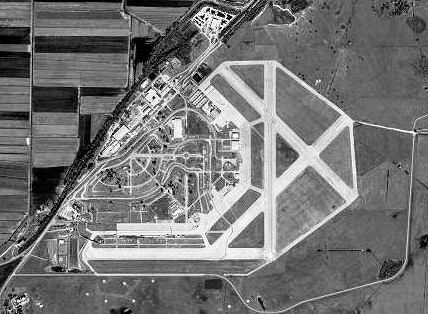
Sebring Regional Airport (IATA: SEF, ICAO: KSEF, FAA LID: SEF) is a general aviation airport located 9 mi southeast of Sebring, in Highlands County, Florida. A portion of the old runway system is now Sebring International Raceway, home to the 12 Hours of Sebring, an American Le Mans series race, which has been held annually since 1952. The airport is also home to a business park and is a Department of Commerce-certified Foreign Trade Zone—FTZ No. 215. HistorySebring Regional Airport was originally constructed in 1940 as Hendricks Field, a B-17 Flying Fortress crew training base of the US Army Air Corps, later the US Army Air Forces. In 1940, Sebring Officials and citizens contacted their Florida congressional delegation to see about getting an Army base in the area. In the summer of 1940, and in early 1941, a group of Army Air Corps officers surveyed the area. On June 12, 1941, Congressman J. Hardin Peterson advised that an area of 9,200 acres of woodland had been approved for a basic flying school. The City of Sebring purchased the land and leased it to the government at $1 per year for 99 years. On July 20, 1941 construction began with Cleary Brothers of West Palm Beach as the General Contractor and Colonel A.H. Bond of the US Army Corps of Engineers in charge. Major Leonard H. Rodieck, who had designed the base, provided oversight for the Army Air Corps. A railroad spur was extended to the installation, followed by construction of the air base facilities and infrastructure. In time, the base became a self-supporting city with paved streets, water and sewage systems, frame buildings, 2-story barracks, and 4 concrete runways, each 300 feet wide by 5000 feet long. The first soldiers arrived on September 5, 1941 and initially occupied tents on the shore of Lake Jackson on the edge of Sebring until they moved onto the base in December when the first barracks were completed. While under construction, the base was known, unofficially, as Kehoe Field, either by joke or by error. The base achieved its initial operating capability and was placed under command of Major Roderick on June 26, 1941. Following the attack on Pearl Harbor, the base's status was upgraded to full operational capability and placed under the command of Colonel Carl B. McDaniel. On January 14, 1942, the base was named Hendricks Field in honor of 1st Lieutenant Laird Woodruff Hendricks, Jr. A native Floridian, Hendricks was born in Ocala, Florida, grew up in Jacksonville, Florida and graduated from the US Military Academy at West Point in 1939. Commissioned into the Army Air Corps, Hendricks completed flight training and received his aeronautical rating as an Army pilot. Lieutenant Hendricks was killed in a B-17 crash in England on July 28, 1941, just three days after he arrived there to train Royal Air Force pilots. On January 29, 1942, the first B-17 was flown into Hendricks Field and pilot and crew training began in earnest in March 1942. By January 1943, Hendricks Field had become a fully functional B-17 training school, and in peak operation about 120 B-17’s were assigned and over 10,000 pilots and other crewmembers were trained. Commanding Officers: Hendricks Field had one of the best safety records in the Army Air Forces. However, there were several crashes, several belly landings, and nine fatal crashes with 45 fatalities. After war’s end in mid-August 1945, the facility was no longer needed to train flight crews. The training program began to wind down during September and October, and by mid-November the order came to inactivate the base by December 31, 1945. The field was deactivated on schedule on December 31 with Colonel Charles D. Farr in command. Following Hendricks Field's official deactivation, Colonel Farr remained at the base to convey the installation to the local community. The field was conditionally turned over to the City of Sebring 25 days later. On February 21, 1946, the city received a permit to operate a civilian airfield on the site and on May 1, 1946, the abandoned airfield was turned over to the City of Sebring to become Sebring Air Terminal, now Sebring Regional Airport & Commerce Park. In December 1950, the first sports car endurance race was held, and since then the world famous 12 Hours of Sebring Grand Prix of Endurance has been held in March each year, with the race track taking the East-West ramp and the closed Runway 9/27, along with some streets of the former air base-turned commerce park. Only the main hangar, restored in 2000, is now in use. New water and sewage systems were completed, and the military's former high water tower, a very noticeable landmark, was brought down in December, 1997. The original military control tower was brought down in December, 1999 and has been restored and re-erected as a historical icon, although the airport continues to operate as an uncontrolled airfield. The airport is also home to the annual Sport Aviation Expo. Passenger ServiceDayJet formerly flew into Sebring Regional Airport through an on-demand system, providing direct flights to approximately one dozen cities. DayJet suspended operations in 19 September 2008; there is no regularly scheduled passenger service into the airport. Accidents and incidents
Sports Car RacingFollowing the end of World War II, aeronautical engineer Alec Ullman, seeking sites to restore military aircraft for civilian use, saw potential in Hendricks Field's runways to stage an sports car endurance race, similar to the 24 Hours of Le Mans. Sebring's first race was held on New Year's Eve of 1950 and the first 12 Hours of Sebring was held on March 15, 1952. The latter would grow to be a major international race. In 1959, the racetrack hosted the first Formula One United States Grand Prix. For much of Sebring's history, the track followed a 5.38 mile (8.66 km) layout. In 1983, the track was changed to allow simultaneous use of the track and one of the runways. In 1987, more changes allowed use of another runway. Further changes in 1991 accommodated expansion of the airport's facilities, and brought the track close to its current configuration. The entire track could now be used without interfering with normal airport operations. Sebring Raceway is one of the oldest continuously-operating race tracks in the United States, its first race being run in 1950. Many consider Sebring to be one of the classic race tracks in North American sports car racing, and the 12 Hours of Sebring, 24 Hours of Daytona, and 24 Hours of Le Mans to be the trifecta of sports car racing. The above content comes from Wikipedia and is published under free licenses – click here to read more.
Runway InformationRunway 14/32
Runway 18/36
Radio Navigation Aids
Remarks
Based Aircraft
Operational StatisticsTime Period: 2005-10-01 - 2006-09-30
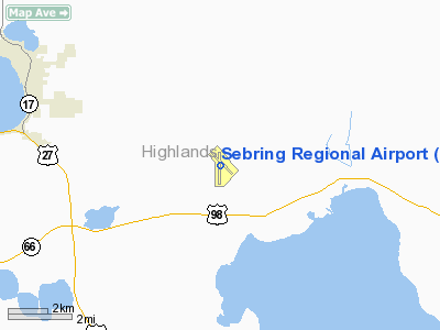
Sebring Regional Airport Address: Highlands County, FL Tel: 863-655-6444, 863-655-6455 Images
and information placed above are from We thank them for the data!
We don't guarantee the information is fresh and accurate. The data may
be wrong or outdated.
|
||||||||||||||||||||||||||||||||||||||||||||||||||||||||||||||||||||||||||||||||||||||||||||||||||||||||||||||||||||||||||||||||||||||||||||||||||||||||||||||||||||||||||||||||||||||||||||||||||||||||||||||||||||||||||||||||||||||||||||||||||||||||||||||||||||||||||||||||||||||||||||||||||||||||||||||||||||||||||||||||

 |
|
Copyright 2004-2024 © by Airports-Worldwide.com, Vyshenskoho st. 36, Lviv 79010, Ukraine Legal Disclaimer |