 |
|
| Ridge Landing Airpark |
 |
| IATA: none – ICAO: none – FAA LID: 4FL5 |
| Summary |
| Airport type |
Private |
| Owner |
John Fazzini |
| Operator |
Ridge Landing Home Owner's Association |
| Location |
Frostproof, Florida |
| Elevation AMSL |
140 ft / 43 m |
| Coordinates |
27°45′19″N 081°35′59″W / 27.75528°N 81.59972°W / 27.75528; -81.59972 |
| Website |
RidgeLandingAirpark.com |
| Runways |
| Direction |
Length |
Surface |
| ft |
m |
| 15/33 |
3,000 |
914 |
Asphalt |
| Source: Airport web site and FAA |
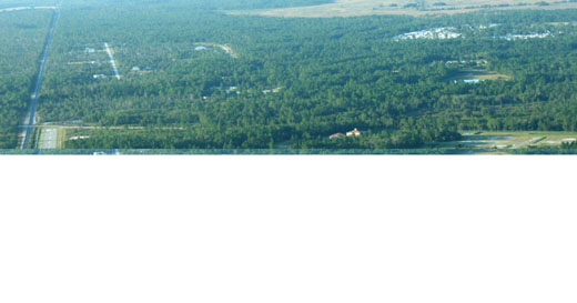
Ridge Landing Airpark (FAA LID: 4FL5), also known as Ridge Landing Airport, is a private use airpark located four nautical miles (7 km) west of the central business district of Frostproof, a city in Polk County, Florida, United States. It is privately owned by John Fazzini. Facilities
Ridge Landing covers an area of 135 acres (55 ha) at an elevation of 140 feet (43 m) above mean sea level. It has one asphalt paved runway designated 15/33 which measures 3,000 by 60 feet (914 x 18 m).
Ridge Landing is a gated community with grass taxiways and all roadways separate. The runway has pilot controlled lighting and is controlled by the Ridge Landing Home Owner's Association.
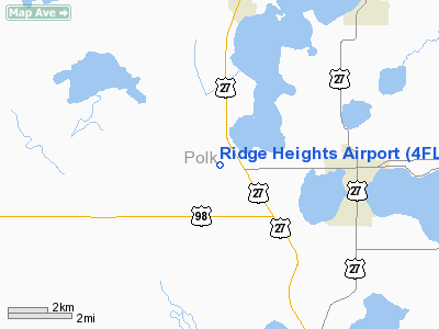
Nearest airports
Public use airports located in the vicinity include:
- X07 - Lake Wales Municipal Airport (8 nm N)
- KAVO - Avon Park Executive Airport (11 nm S)
- KBOW - Bartow Municipal Airport (15 nm NW)
- KGIF - Winter Haven's Gilbert Airport (20 nm NW)
- KCHN - Wauchula Municipal Airport (21 nm SW)
The above content comes from Wikipedia and is published under free licenses – click here to read more.
Location
& QuickFacts
|
FAA Information Effective: |
2007-01-18 |
|
Airport
Identifier: |
4FL5 |
|
Airport
Status: |
Operational |
|
Longitude/Latitude: |
081-36-02.0000W/27-45-26.0000N
-81.600556/27.757222 (Estimated) |
|
Elevation: |
140 ft / 42.67 m (Estimated) |
|
Land: |
135 acres |
|
From
nearest city: |
4 nautical miles W of Frostproof, FL |
|
Location: |
Polk County, FL |
|
Magnetic Variation: |
() |
Owner
& Manager
|
Ownership: |
Privately owned |
|
Owner: |
John Fazzini |
|
Address: |
14420 Hwy 27
Lake Wales, FL 33859 |
|
Phone number: |
863-638-1454 |
|
Manager: |
Tony Nicorvo |
|
Address: |
14420 Hwy 27
Lake Wales, FL 33859 |
|
Phone number: |
863-638-1454 |
Airport
Operations and Facilities
|
Airport Use: |
Private |
|
Segmented
Circle: |
No |
|
Control
Tower: |
No |
|
Sectional
chart: |
Miami |
|
Region: |
ASO - Southern |
|
Boundary
ARTCC: |
ZTL - Atlanta |
|
Responsible
ARTCC: |
ZTL - Atlanta |
|
Tie-in
FSS: |
ANB - Anniston |
|
FSS
Toll Free: |
1-800-WX-BRIEF |
|
Runway Information
Runway 15/33
|
Dimension: |
3000 x 125 ft / 914.4 x 38.1 m |
|
Surface: |
TURF, |
|
|
Runway 15 |
Runway 33 |
|
Traffic
Pattern: |
Left |
Right |
|
Obstruction: |
70 ft trees, 900.0 ft from runway |
30 ft trees, 875.0 ft from runway |
|
Radio Navigation
Aids
|
ID |
Type |
Name |
Ch |
Freq |
Var |
Dist |
|
CHN |
NDB |
Wauchula |
|
261.00 |
04W |
21.2 nm |
|
PCM |
NDB |
Plant City |
|
346.00 |
02W |
33.0 nm |
|
ISM |
NDB |
Kissimmee |
|
329.00 |
05W |
33.2 nm |
|
RHZ |
NDB |
Zephyrhills |
|
253.00 |
03W |
40.9 nm |
|
TPF |
NDB |
Knight |
|
270.00 |
02W |
46.3 nm |
|
MCF |
TACAN |
Macdill |
047X |
|
04W |
48.9 nm |
|
LAL |
VORTAC |
Lakeland |
107X |
116.00 |
01E |
25.9 nm |
|
ORL |
VORTAC |
Orlando |
059X |
112.20 |
00E |
49.3 nm |
Remarks
- PRVDD
VFR OPNS & PVT USE. MAINTAIN LOA WITH LAKE CLINCH AIRPARK SUCH THAT
TRAFFIC PATTERN AT RIDGE HEIGHTS ARPT IS SSW OF RY.
Ridge Heights Airport
Address:
Polk County, FL
Tel:
863-638-1454
Images
and information placed above are from
http://www.airport-data.com/airport/4FL5/
We
thank them for the data!
We don't guarantee the information is fresh and accurate. The data may
be wrong or outdated.
For more up-to-date information please refer to other sources.
|
|


