 |
|
Pompano Beach Airpark Airport |
| Pompano Beach Airpark |
| IATA: PPM – ICAO: KPMP – FAA LID: PMP |
| Summary |
| Airport type |
Public |
| Owner |
City of Pompano Beach |
| Location |
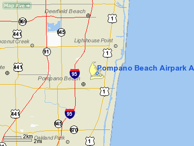
Pompano Beach, Florida |
| Elevation AMSL |
19 ft / 6 m |
| Coordinates |
26°14′50″N 080°06′40″W / 26.24722°N 80.11111°W / 26.24722; -80.11111 |
| Runways |
| Direction |
Length |
Surface |
| ft |
m |
| 6/24 |
4,001 |
1,220 |
Asphalt |
| 10/28 |
3,502 |
1,067 |
Asphalt |
| 15/33 |
4,418 |
1,347 |
Asphalt |
| Statistics (1999) |
| Aircraft operations |
169,722 |
| Based aircraft |
158 |
| Source: Federal Aviation Administration |
Pompano Beach Airpark (IATA: PPM, ICAO: KPMP, FAA LID: PMP) is a public airport located one mile (1.6 km) northeast of the central business district of Pompano Beach, in Broward County, Florida, United States. This airport is publicly owned by City of Pompano Beach.
Although most U.S. airports use the same three-letter location identifier for the FAA and IATA, Pompano Beach Airpark is assigned PMP by the FAA and PPM by the IATA (which assigned PMP to Pimaga, Papua New Guinea). The airport's ICAO identifier is KPMP. Facilities and aircraft
Pompano Beach Airpark covers an area of 935 acres (3.78 km) which contains three runways:
- Runway 6/24: 4,001 × 150 ft (1,220 × 46 m), Surface: Asphalt
- Runway 10/28: 3,502 × 100 ft (1,067 × 30 m), Surface: Asphalt
- Runway 15/33: 4,418 × 150 ft (1,347 × 46 m), Surface: Asphalt
The airport also has an operational air traffic control tower under the FAA Contract Tower Program.
For 12-month period ending 15 July 1999 the airport had 169,722 aircraft operations, an average of 464 per day: 99% general aviation (169,506), <1% air taxi (136) and <1% military (80). There are 158 aircraft based at this airport: 79% single engine (125), 8% multi engine (12), 3% jet aircraft (4) and 11% helicopters (17).
The Goodyear Blimp N2A is based out of Pompano Beach Airpark.
History
Pompano Beach Airport was constructed during World War II as an outlying field (OLF) for Naval Air Station Fort Lauderdale, what is now the Fort Lauderdale-Hollywood International Airport. On August 29, 1947, the City of Pompano Beach obtained the Airport under the Surplus Property Act of 1944 and renamed it Pompano Beach Air Park, due to its intent to limit the airport's usage to general aviation. For the same reason, the City shortened Runway 15-33 from its original length of 5,000 feet to its current length of 4,418 feet in 1971.
Additional lands surrounding the Air Park, including land along Copans Road and the Florida East Coast Railway tracks to the west of the Air Park, were transferred to the City on June 24, 1948, bringing the total acreage at the Air Park to 1,035 acres. On August 5, 1958, 10 acres of Air Park property were released to the Broward County School Board for the construction of Pompano Beach Elementary School. The County received 9 more acres on September 18, 1967. On March 8, 1958, the City sold 60 acres, located in the northeast corner of the Air Park Property, for development of the Pompano Square Mall. The final transfer of Air Park property occurred in 1981 when 10 acres in the southwestern section of the Air Park Property were purchased by the Pompano Elks Club. These transfers account for the current total 946 acres of the Air Park.
Pompano Beach Air Park is owned by the City of Pompano Beach. The Air Park is a Surplus Property Act airport, with the Surplus Property Act of 1944 states that any lands conveyed under the act must be used for aviation purposes or ownership reverts back to the FAA. The FAA can, however, release excess portions of the property for non-aviation purposes, and any proceeds from the sale of excess property must be used to support airport growth and development under the stipulations of the Surplus Property Act.
The above content comes from Wikipedia and is published under free licenses – click here to read more.
Location
& QuickFacts
|
FAA Information Effective: |
2007-01-18 |
|
Airport
Identifier: |
PMP |
|
Airport
Status: |
Operational |
|
Longitude/Latitude: |
080-06-39.8000W/26-14-49.7000N
-80.111056/26.247139 (Estimated) |
|
Elevation: |
19 ft / 5.79 m (Surveyed) |
|
Land: |
935 acres |
|
From
nearest city: |
1 nautical miles NE of Pompano Beach, FL |
|
Location: |
Broward County, FL |
|
Magnetic Variation: |
03W (1985) |
Owner
& Manager
|
Ownership: |
Publicly owned |
|
Owner: |
City Of Pompano Beach |
|
Address: |
City Hall, Box 1300
Pompano Beach, FL 33061 |
|
Phone
number: |
954-786-4135 |
|
Manager: |
Steve Rocco |
|
Address: |
1001 Ne 10th St
Pompano Beach, FL 33060 |
|
Phone number: |
954-786-4135 |
Airport
Operations and Facilities
|
Airport Use: |
Open to public |
|
Wind
indicator: |
Yes |
|
Segmented
Circle: |
No |
|
Control
Tower: |
Yes |
|
Lighting
Schedule: |
DUSK-DAWN
WHEN ATCT CLSD MIRL RY 15/33 & RY MOST ALIGNED TO WIND
PRESET MED INTST ONLY. |
|
Beacon
Color: |
Clear-Green (lighted land airport) |
|
Landing
fee charge: |
No |
|
Sectional
chart: |
Miami |
|
Region: |
ASO - Southern |
|
Boundary
ARTCC: |
ZMA - Miami |
|
Tie-in
FSS: |
MIA - Miami |
|
FSS
on Airport: |
No |
|
FSS
Phone: |
305-233-2600 |
|
FSS
Toll Free: |
1-800-WX-BRIEF |
|
NOTAMs
Facility: |
PMP (NOTAM-d service avaliable) |
|
Federal Agreements: |
NPRVY |
Airport
Communications
|
CTAF: |
125.400 |
|
Unicom: |
122.950 |
Airport
Services
|
Fuel available: |
100LLA |
|
Airframe Repair: |
MAJOR |
|
Power Plant Repair: |
MAJOR |
|
Bottled
Oxygen: |
HIGH/LOW |
|
Bulk
Oxygen: |
HIGH/LOW |
|
Runway Information
Runway 06/24
|
Dimension: |
4001 x 150 ft / 1219.5 x 45.7 m |
|
Surface: |
ASPH, Fair Condition |
|
Weight
Limit: |
Single wheel: 20000 lbs.
RY 06/24 & RY 10/28 LIMITED TO GWT 12500 LBS OR LESS BY AMGR. |
|
Edge
Lights: |
Medium |
|
|
Runway 06 |
Runway 24 |
|
Longitude: |
080-06-59.5731W |
080-06-24.6387W |
|
Latitude: |
26-14-38.2916N |
26-15-02.3232N |
|
Elevation: |
19.00
ft |
13.00
ft |
|
Alignment: |
53 |
127 |
|
Traffic
Pattern: |
Left |
Left |
|
Markings: |
Basic, Good Condition |
Basic, Good Condition |
|
Crossing
Height: |
39.00 ft |
44.00 ft |
|
VASI: |
2-box on left side |
2-box on left side |
|
Visual
Glide Angle: |
3.25� |
3.25� |
|
Runway
End Identifier: |
Yes |
|
|
Obstruction: |
30 ft trees, 968.0 ft from runway, 25:1 slope
to clear |
26 ft trees, 720.0 ft from runway, 20:1 slope
to clear |
|
Runway 10/28
|
Dimension: |
3502 x 100 ft / 1067.4 x 30.5 m |
|
Surface: |
ASPH, Fair Condition |
|
Weight
Limit: |
Single wheel: 26000 lbs.
RY 06/24 & RY 10/28 LIMITED TO GWT 12500 LBS OR LESS BY AMGR. |
|
Edge
Lights: |
Medium |
|
|
Runway 10 |
Runway 28 |
|
Longitude: |
080-06-59.8142W |
080-06-21.6963W |
|
Latitude: |
26-14-45.3834N |
26-14-40.7733N |
|
Elevation: |
18.00
ft |
10.00
ft |
|
Alignment: |
98 |
127 |
|
Traffic
Pattern: |
Left |
Left |
|
Markings: |
Basic, Good Condition |
Basic, Good Condition |
|
Crossing
Height: |
51.00 ft |
54.00 ft |
|
VASI: |
2-box on left side |
2-box on left side |
|
Visual
Glide Angle: |
3.25� |
3.25� |
|
Runway
End Identifier: |
Yes |
|
|
Obstruction: |
39 ft trees, 1230.0 ft from runway, 150 ft
right of centerline, 26:1 slope to clear |
22 ft trees, 900.0 ft from runway, 21:1 slope
to clear |
|
Runway 15/33
|
Dimension: |
4418 x 150 ft / 1346.6 x 45.7 m |
|
Surface: |
ASPH, Fair Condition |
|
Weight
Limit: |
Single wheel: 30000 lbs.
RY 06/24 & RY 10/28 LIMITED TO GWT 12500 LBS OR LESS BY AMGR. |
|
Edge
Lights: |
Medium |
|
|
Runway 15 |
Runway 33 |
|
Longitude: |
080-06-51.6832W |
080-06-22.2480W |
|
Latitude: |
26-15-11.7257N |
26-14-36.9424N |
|
Elevation: |
16.00
ft |
11.00
ft |
|
Alignment: |
127 |
127 |
|
ILS
Type: |
LOC/DME |
|
|
Traffic
Pattern: |
Left |
Left |
|
Markings: |
Non-precision instrument, Good Condition |
Basic, Good Condition |
|
Crossing
Height: |
48.00 ft |
55.00 ft |
|
VASI: |
2-box on left side |
2-box on left side |
|
Visual
Glide Angle: |
3.25� |
3.75� |
|
Approach
lights: |
ODALS
RY 15 ODALS OTS INDEFLY. |
|
|
Runway
End Identifier: |
|
Yes |
|
Obstruction: |
44 ft trees, 1300.0 ft from runway, 25:1 slope
to clear |
38 ft trees, 972.0 ft from runway, 20:1 slope
to clear |
|
Radio Navigation
Aids
|
ID |
Type |
Name |
Ch |
Freq |
Var |
Dist |
|
PJN |
NDB |
Plantation |
|
242.00 |
03W |
9.0 nm |
|
FX |
NDB |
Praiz |
|
221.00 |
02W |
10.8 nm |
|
PB |
NDB |
Rubin |
|
356.00 |
03W |
27.0 nm |
|
UTX |
NDB |
United |
|
405.00 |
03W |
41.6 nm |
|
HST |
TACAN |
Homestead |
019X |
|
03W |
47.8 nm |
|
FLL |
VOR/DME |
Fort Lauderdale |
091X |
114.40 |
00E |
10.6 nm |
|
VKZ |
VOR/DME |
Virginia Key |
118X |
117.10 |
04W |
29.9 nm |
|
PBI |
VORTAC |
Palm Beach |
104X |
115.70 |
03W |
26.1 nm |
|
DHP |
VORTAC |
Dolphin |
086X |
113.90 |
04W |
29.8 nm |
|
PHK |
VORTAC |
Pahokee |
101X |
115.40 |
00E |
44.8 nm |
|
PBI |
VOT |
Palm Beach |
|
109.00 |
|
26.5 nm |
|
MIA |
VOT |
Miami Intl |
|
112.00 |
|
28.7 nm |
Remarks
- NUMEROUS
BIRDS ON & INVOF ARPT.
- ACFT
WITH GWT MORE THAN 30000 LBS PROHIBITED ON RY 15/33.
- GOLF
DRIVING RANGE IN APCH ZONE TO RY 28.
- ALL
RYS NOISE SENSITIVE; CONTACT AMGR FOR HEL & FIXED WING OPERATING
PROCEDURES - 305-786-4135.
- CRANE
170 FT 2000 NE RY 06/24 FLAG LOWERED AT NIGHT INDEFLY.
Based
Aircraft
|
Aircraft
based on field: |
158 |
|
Single
Engine Airplanes: |
125 |
|
Multi
Engine Airplanes: |
12 |
|
Jet Engine
Airplanes: |
4 |
|
Helicopters: |
17
BELL HELICOPTER SERVICE CENTER ON ARPT. |
Operational
Statistics
Time Period:
1998-07-16 - 1999-07-15
|
Aircraft
Operations: |
465/Day |
|
Air Taxi: |
0.1% |
|
General
Aviation Local: |
69.0% |
|
General
Aviation Itinerant: |
30.8% |
|
Military: |
0.0% |
Greystone Airport
Address:
Broward County, FL
Tel:
954-786-4135
Images
and information placed above are from
http://www.airport-data.com/airport/PMP/
We
thank them for the data!
| General
Info |
| Country |
United
States |
| State |
FLORIDA
|
| FAA ID |
PMP
|
| Latitude |
26-14-49.700N
|
| Longitude |
080-06-39.800W
|
| Elevation |
19 feet
|
| Near City |
POMPANO
BEACH |
We don't guarantee the information is fresh and accurate. The data may
be wrong or outdated.
For more up-to-date information please refer to other sources.
|
|


