|
|
Plant City Municipal Airport |
| Plant City Airport |
| IATA: none – ICAO: KPCM – FAA LID: PCM |
| Summary |
| Airport type |
Public |
| Owner |
Hillsborough County Aviation Authority |
| Serves |
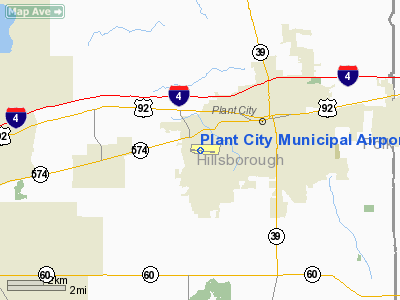
Plant City, Florida |
| Elevation AMSL |
154 ft / 47 m |
| Coordinates |
28°00′01″N 082°09′51″W / 28.00028°N 82.16417°W / 28.00028; -82.16417 |
| Website |
www.pcairport.net |
| Runways |
| Direction |
Length |
Surface |
| ft |
m |
| 10/28 |
3,950 |
1,204 |
Asphalt |
| Statistics (2002) |
| Aircraft operations |
47,975 |
| Based aircraft |
72 |
| Source: Federal Aviation Administration |
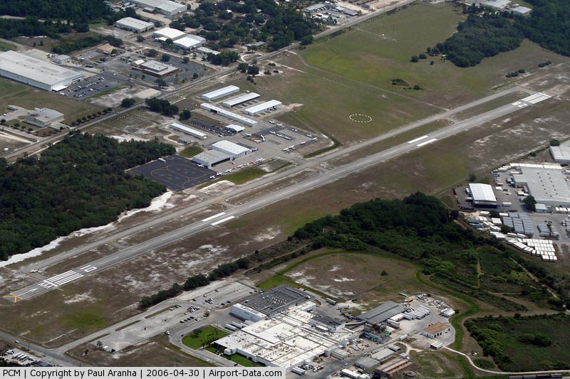
Plant City Airport (ICAO: KPCM, FAA LID: PCM) is a public-use airport located two nautical miles (4 km) southwest of the central business district of Plant City in Hillsborough County, Florida, United States. The airport is publicly owned by the Hillsborough County Aviation Authority, which also operates Tampa International Airport. It was formerly known as Plant City Municipal Airport. It supports a 400 acres industrial park located about one mile east of the airport.
Although most U.S. airports use the same three-letter location identifier for the FAA and IATA, this airport is assigned PCM by the FAA but has no designation from the IATA. History
Plant City was originally a large cotton center but switched to strawberries which brought it national recognition. It was named for the city's well known railroad tycoon, Henry B. Plant.
The Plant City Municipal Airport was founded in 1948 to ship strawberries. Runway 09/27 was lengthened in 1999 and redesignated 10/28. In 2000, a new terminal was constructed, along with two new hangars (E and F) and a new Jet-A fuel tank.
Facilities and aircraft
Plant City Airport covers an area of 199 acres (81 ha) at an elevation of 154 feet (47 m) above mean sea level. It has one asphalt paved runway designated 10/28 which measures 3,950 x 75 ft (1,204 x 23 m). For the 12-month period ending May 9, 2002, the airport had 47,975 aircraft operations, an average of 131 per day: 99.5% general aviation, 0.4% air taxi and <0.1% military. At that time there were 72 aircraft based at this airport: 83% single-engine, 13% multi-engine and 4% helicopter. The local fixed base operator is Plant City Airport Services.
The above content comes from Wikipedia and is published under free licenses – click here to read more.
|
 |
(Click on the photo to enlarge) |
Location
& QuickFacts
|
FAA Information Effective: |
2007-01-18 |
|
Airport
Identifier: |
PCM |
|
Airport
Status: |
Operational |
|
Longitude/Latitude: |
082-09-51.2700W/28-00-00.7800N
-82.164242/28.000217 (Estimated) |
|
Elevation: |
154 ft / 46.94 m (Surveyed) |
|
Land: |
199 acres |
|
From
nearest city: |
2 nautical miles SW of Plant City, FL |
|
Location: |
Hillsborough County, FL |
|
Magnetic Variation: |
02W (1985) |
Owner
& Manager
|
Ownership: |
Publicly owned |
|
Owner: |
Hillsborough Co Avn Authority |
|
Address: |
Po Box 22287
Tampa, FL 33622 |
|
Phone
number: |
813-870-8711 |
|
Manager: |
Susan Hardman
STAFF; HILLSBORO CNTY AVN AUTH. |
|
Address: |
Po Box 22287
Tampa, FL 33622 |
|
Phone number: |
813-870-8775
FBO 813-752-4710. |
Airport
Operations and Facilities
|
Airport Use: |
Open to public |
|
Wind
indicator: |
Yes |
|
Segmented
Circle: |
Yes |
|
Control
Tower: |
No |
|
Lighting
Schedule: |
DUSK-DAWN
ACTVT MIRL RY 10/28, PAPI RYS 10 & 28 AND REILS RYS
10 & 28 - CTAF. |
|
Beacon
Color: |
Clear (unlighted land airport) |
|
Landing
fee charge: |
No |
|
Sectional
chart: |
Jacksonville |
|
Region: |
ASO - Southern |
|
Boundary
ARTCC: |
ZMA - Miami |
|
Tie-in
FSS: |
PIE - Saint Petersburg |
|
FSS
on Airport: |
No |
|
FSS
Toll Free: |
1-800-WX-BRIEF |
|
NOTAMs
Facility: |
PCM (NOTAM-d service avaliable) |
|
Federal Agreements: |
NGY |
Airport
Communications
|
CTAF: |
123.000 |
|
Unicom: |
123.000
OTS INDEFLY. |
Airport
Services
|
Fuel available: |
100LLA |
|
Airframe Repair: |
MAJOR |
|
Power Plant Repair: |
MAJOR |
|
Bottled
Oxygen: |
NONE |
|
Bulk
Oxygen: |
NONE |
|
Runway Information
Runway 10/28
|
Dimension: |
3950 x 75 ft / 1204.0 x 22.9 m |
|
Surface: |
ASPH, Good Condition |
|
Weight
Limit: |
Single wheel: 20000 lbs. |
|
Edge
Lights: |
Non-standard lighting system
RY 10/28 NSTD MIRL: FIRST 200 FT RY 10 TO DSPLCD THLD UNLGTD. |
|
|
Runway 10 |
Runway 28 |
|
Longitude: |
082-10-09.8900W |
082-09-25.9500W |
|
Latitude: |
28-00-02.0000N |
27-59-59.1200N |
|
Elevation: |
153.00 ft |
144.00 ft |
|
Alignment: |
94 |
127 |
|
Traffic
Pattern: |
Left |
Left |
|
Markings: |
Non-precision instrument, Good Condition |
Non-precision instrument, Good Condition |
|
Crossing
Height: |
22.00
ft |
24.00 ft |
|
Displaced
threshold: |
200.00 ft |
0.00
ft |
|
VASI: |
2-light PAPI on left side |
2-light PAPI on left side |
|
Visual
Glide Angle: |
3.00� |
3.00� |
|
Runway
End Identifier: |
Yes |
Yes |
|
Obstruction: |
34 ft trees, 666.0 ft from runway, 12:1 slope
to clear
RY 10 APCH RATIO 25:1 TO DSPLCD THLD. |
24 ft trees, 74.0 ft from runway, 22:1 slope
to clear |
|
Radio Navigation
Aids
|
ID |
Type |
Name |
Ch |
Freq |
Var |
Dist |
|
PCM |
NDB |
Plant City |
|
346.00 |
02W |
0.4 nm |
|
RHZ |
NDB |
Zephyrhills |
|
253.00 |
03W |
13.6 nm |
|
TPF |
NDB |
Knight |
|
270.00 |
02W |
16.4 nm |
|
AM |
NDB |
Picny |
|
388.00 |
02W |
21.9 nm |
|
CHN |
NDB |
Wauchula |
|
261.00 |
04W |
33.0 nm |
|
ISM |
NDB |
Kissimmee |
|
329.00 |
05W |
42.4 nm |
|
MCF |
TACAN |
Macdill |
047X |
|
04W |
20.3 nm |
|
LAL |
VORTAC |
Lakeland |
107X |
116.00 |
01E |
8.0 nm |
|
PIE |
VORTAC |
St Petersburg |
111X |
116.40 |
01E |
28.2 nm |
|
SRQ |
VORTAC |
Sarasota |
099X |
115.20 |
02W |
41.7 nm |
|
TPA |
VOT |
Tampa Intl |
|
111.00 |
|
19.6 nm |
Remarks
- 3
TV TWRS 1099' & 2 AT 1549' MSL 12 NM SSW.
Based
Aircraft
|
Aircraft
based on field: |
72 |
|
Single
Engine Airplanes: |
60 |
|
Multi
Engine Airplanes: |
10 |
|
Jet Engine
Airplanes: |
1 |
|
Helicopters: |
1 |
Operational Statistics
Time Period: 2001-05-10
- 2002-05-09
|
Aircraft
Operations: |
132/Day |
|
Air Taxi: |
0.4% |
|
General
Aviation Local: |
76.6% |
|
General
Aviation Itinerant: |
22.9% |
|
Military: |
0.1% |
Plant City Municipal Airport
Address:
Hillsborough County, FL
Tel:
813-870-8711,
813-870-8775
Images
and information placed above are from
http://www.airport-data.com/airport/PCM/
We
thank them for the data!
| General
Info |
| Country |
United
States |
| State |
FLORIDA
|
| FAA ID |
PCM
|
| Latitude |
28-00-00.780N
|
| Longitude |
082-09-51.270W
|
| Elevation |
154 feet
|
| Near City |
PLANT
CITY |
We don't guarantee the information is fresh and accurate. The data may
be wrong or outdated.
For more up-to-date information please refer to other sources.
|
|