 |
|
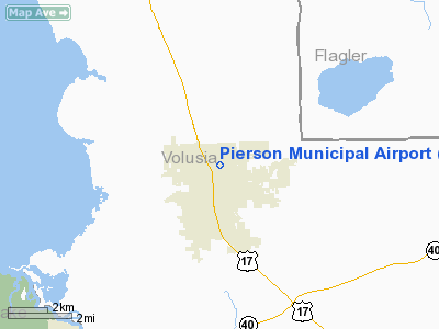
Pierson Municipal Airport |
|
|
Location
& QuickFacts
|
FAA Information Effective: |
2007-01-18 |
|
Airport
Identifier: |
2J8 |
|
Airport
Status: |
Operational |
|
Longitude/Latitude: |
081-27-33.2490W/29-14-59.9210N
-81.459236/29.249978 (Estimated) |
|
Elevation: |
63 ft / 19.20 m (Surveyed) |
|
Land: |
147 acres |
|
From
nearest city: |
1 nautical miles N of Pierson, FL |
|
Location: |
Volusia County, FL |
|
Magnetic Variation: |
03W (1985) |
Owner
& Manager
|
Ownership: |
Publicly owned |
|
Owner: |
Town Of Pierson |
|
Address: |
P.o. Box 527
Pierson, FL 32180 |
|
Phone
number: |
904-749-0516 |
|
Manager: |
Freeman Greenlund |
|
Address: |
P.o. Box 527
Pierson, FL 32180 |
|
Phone number: |
904-749-0516 |
Airport
Operations and Facilities
|
Airport Use: |
Open to public |
|
Wind
indicator: |
Yes |
|
Segmented
Circle: |
Yes |
|
Control
Tower: |
No |
|
Landing
fee charge: |
No |
|
Sectional
chart: |
Jacksonville |
|
Region: |
ASO - Southern |
|
Boundary
ARTCC: |
ZJX - Jacksonville |
|
Tie-in
FSS: |
PIE - Saint Petersburg |
|
FSS
on Airport: |
No |
|
FSS
Toll Free: |
1-800-WX-BRIEF |
|
NOTAMs
Facility: |
PIE (NOTAM-d service avaliable) |
Airport
Communications
Airport
Services
|
Airframe Repair: |
NONE |
|
Power Plant Repair: |
NONE |
|
Bottled
Oxygen: |
NONE |
|
Bulk
Oxygen: |
NONE |
|
Runway Information
Runway 05/23
|
Dimension: |
2600 x 200 ft / 792.5 x 61.0 m |
|
Surface: |
TURF, Fair Condition |
|
|
Runway 05 |
Runway 23 |
|
Traffic
Pattern: |
Left |
Right |
|
Obstruction: |
60 ft trees, 1200.0 ft from runway, 20:1 slope
to clear |
30 ft trees, 610.0 ft from runway, 125 ft left
of centerline, 20:1 slope to clear |
|
Radio Navigation
Aids
|
ID |
Type |
Name |
Ch |
Freq |
Var |
Dist |
|
DED |
NDB |
Deland/dcmsnd |
|
201.00 |
05W |
14.6 nm |
|
EVB |
NDB |
New Smyrna Beach |
|
417.00 |
04W |
29.6 nm |
|
SFB |
NDB |
Sanford |
|
408.00 |
05W |
30.2 nm |
|
IAK |
NDB |
Palatka |
|
243.00 |
05W |
30.4 nm |
|
LEE |
NDB |
Leesburg |
|
335.00 |
04W |
31.7 nm |
|
GN |
NDB |
Wynds |
|
269.00 |
04W |
45.1 nm |
|
SGJ |
VOR/DME |
St Augustine |
031X |
109.40 |
06W |
43.0 nm |
|
OMN |
VORTAC |
Ormond Beach |
073X |
112.60 |
00E |
18.4 nm |
|
OCF |
VORTAC |
Ocala |
084X |
113.70 |
00E |
40.5 nm |
|
ORL |
VORTAC |
Orlando |
059X |
112.20 |
00E |
43.0 nm |
|
DAB |
VOT |
Daytona Beach |
|
111.00 |
|
21.6 nm |
Remarks
- 30
FT TREES + OR - 110 FT FM CNTRLN FULL LENGTH RY 05/23.
- CENTER
40 FT OF RWY IN FAIR COND, REMAINDER IN POOR COND.
- EXISTED
PRIOR TO 1959.
Based
Aircraft
|
Aircraft
based on field: |
5 |
|
Single
Engine Airplanes: |
5 |
Operational Statistics
Time Period: 1998-05-20
- 1999-05-19
|
Aircraft
Operations: |
270/Week |
|
General
Aviation Local: |
28.8% |
|
General
Aviation Itinerant: |
71.2% |
Pierson Municipal Airport
Address:
Volusia County, FL
Tel:
904-749-0516
Images
and information placed above are from
http://www.airport-data.com/airport/2J8/
We
thank them for the data!
| General
Info |
| Country |
United
States |
| State |
FLORIDA
|
| FAA ID |
2J8
|
| Latitude |
29-14-59.921N
|
| Longitude |
081-27-33.249W
|
| Elevation |
63 feet
|
| Near City |
PIERSON
|
We don't guarantee the information is fresh and accurate. The data may
be wrong or outdated.
For more up-to-date information please refer to other sources.
|
|


