|
 |
|
||||
|
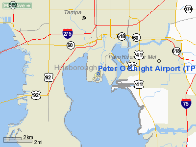
Peter O. Knight Airport (IATA: TPF, ICAO: KTPF, FAA LID: TPF) is an airport on Davis Islands, five minutes from downtown Tampa, Florida. Built as a Works Progress Administration project, it was Tampa's main airport from 1935 to 1945, and is still used by general aviation operators today because of its proximity to the central city. The airport was named for prominent attorney and businessman Peter O. Knight, namesake of Holland & Knight. The airport's original administration building was torn down in the 1960s, and replaced by the current building. Although seaplanes aren't quite as popular anymore, the basin is still there at Davis Islands The local fixed base operator (FBO) was recently sold by Tampa Flying Service and is now operated by Atlas Aviation. The residents of Davis Island where the airport is located have complained about the noise and appearance of the facilities. The current plan is to extend the north east end of the runway by 65 feet, and add 175 feet to the south end of the runway. During a meeting on September 18, 2007 some residents voiced concerns about larger aircraft using the longer runway, and any related increase in the volume of noise generated there. Sound tests conducted by the Aviation Authority showed an increase of 3db or less over current usage at the closest residences, or an average of about 58db during run ups to take off. During the same tests, nearby lawn mowers, motorcycles, and automobiles frequently reached over 75db. Facilities and aircraftPeter O. Knight Airport covers an area of 110 acres (45 ha) at an elevation of 8 feet (2 m) above mean sea level. It has two asphalt paved runways: 3/21 measuring 3,405 by 100 feet (1,038 x 30 m) and 17/35 measuring 2,688 x 75 feet (819 x 23 m). The airport is currently operating under a regulation waiver (basically a temporary permit), until a safety zone of 240 feet can be added to the main runway. Additionally, the demand for space at the airport continues to increase. The waiting list for enclosed hangar space has reached over 130. For the 12-month period ending June 8, 1999, the airport had 66,000 aircraft operations, an average of 180 per day: 99% general aviation and 1% air taxi. At that time there were 102 aircraft based at this airport: 82% single-engine, 11% multi-engine, 2% jet and 5% helicopter. The Hillsborough Aviation Authority has authorized an expenditure of over $1.8 million to add the required runway extension, and to build additional hangar space on the east side of the runway, adjacent to Seddon Channel. Plans are for 13 new hangar spaces to be completed by the end of 2008 IncidentsOn February 20, 1975, professional wrestler Buddy Colt, while attempting to land in bad weather, crashed into Hillsborough Bay 300 feet short of the runway. Passenger Robert Shoenberger ("Bobby Shane") was killed. On June 12, 2006, a small aircraft attempting to make an emergency landing at the airport skidded off a runway , through a retaining fence, and into the residence of a local business owner, causing complete destruction of the home. The pilot, Steve Huisman, was killed and the co-pilot, Sean Lauder, was hospitalized with serious injuries. Only one person was in the house at the time of impact, escaping without injury. The home was later demolished and rebuilt by ABC's Extreme Makeover: Home Edition. November 28, 2008 A local plastic surgeon and a 19-year-old man were injured when a Extra 300 single engine plane was making its final approach. It hit a 50-foot sailboat mast and hit the seawall before the runway. The plane flipped onto the tarmac. World War IIDuring World War II, the airport was used as an axillary fighter landing field for Clearwater; Drew and MacDill fields supporting Third Air Force group and replacement training activities. The above content comes from Wikipedia and is published under free licenses – click here to read more.
Runway InformationRunway 03/21
Runway 17/35
Radio Navigation Aids
Remarks
Based Aircraft
Operational StatisticsTime Period: 1998-06-09 - 1999-06-08
Peter O Knight Airport Address: Hillsborough County, FL Tel: 813-870-8711 Images
and information placed above are from We thank them for the data!
We don't guarantee the information is fresh and accurate. The data may
be wrong or outdated.
|
|||||||||||||||||||||||||||||||||||||||||||||||||||||||||||||||||||||||||||||||||||||||||||||||||||||||||||||||||||||||||||||||||||||||||||||||||||||||||||||||||||||||||||||||||||||||||||||||||||||||||||||||||||||||||||||||||||||||||||||||||||||||||||||||||||||||||||||||||||||||||||||||||||||||||||||||||||||||||||||||||||||||||||||||||||||||||||||||||||||||||||||||||||||||||||

 |
|
Copyright 2004-2024 © by Airports-Worldwide.com, Vyshenskoho st. 36, Lviv 79010, Ukraine Legal Disclaimer |