Panama City-bay Company International Airport in Florida Florida airports - Panama City-bay Company International Airport
Panama City-bay Company International Airport in Florida - United States
Florida Airports
USA Airports
World Airports
Airport photos - free!
Aircraft photos - free!
Spacecraft pics - free!
Aviation Articles

Panama City-bay Company International Airport


Panama City-Bay County International Airport
IATA: PFN – ICAO: KPFN – FAA LID: PFN
Summary
Airport type Public
Owner LUK-MB1 LLC
Serves Panama City, Florida
Elevation AMSL 20 ft / 6 m
Coordinates 30°12′44″N 085°40′58″W / 30.21222°N 85.68278°W / 30.21222; -85.68278
Website www.PCairport.com
Runways
Direction Length Surface
ft m
14/32 6,308 1,923 Asphalt
5/23 4,884 1,489 Asphalt
Statistics (2007)
Aircraft operations 84,445
Based aircraft 133
Source: Federal Aviation Administration

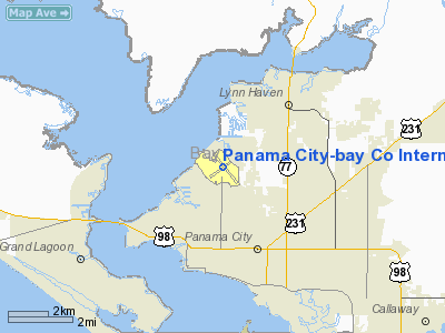
Panama City-Bay County International Airport (IATA: PFN, ICAO: KPFN, FAA LID: PFN) is a former public use airport located three nautical miles (6 km) northwest of the central business district of Panama City, in Bay County, Florida, United States. It is owned by LUK-MB1, LLC which plans to remove the runways and build homes, shops, walking trails and a marina. All commercial airline services were relocated to the Northwest Florida Beaches International Airport on May 22, 2010, however it continues to service general aviation private flights.

History

Panama City–Bay County International Airport (PFN) began as a private field owned by J.B. Atkinson, Jr., a citizen of Panama City. The facility consisted of 292 acres (1.2 km²) of land with grass landing strips. In 1932, Mr. and Mrs. Atkinson, Jr. donated the property to the Panama City Chamber of Commerce so that a city airport could be established. At that time the airport was named Atkinson Field. In 1938, Panama City and the Bay County Commissioners joined forces to develop the Airport through the construction of an airport terminal and extensive airfield expansion. The facility’s $604,000 development project included the construction of a small passenger terminal and two 4,000-foot (1,200 m) intersecting runways. After the expansion was completed, the airport was renamed Fannin Field in honor of the Panama City mayor during this period.

Throughout World War II, the airport was used as a Civil Air Patrol facility. In 1943, the Florida legislature approved the formation of an airport authority, the Panama City-Bay County Airport and Industrial District, to manage Fannin Field, or Panama City-Bay County Airport, as it became commonly known. In 1948, commercial operations at the airport commenced.

The airport continued to be served by commercial airlines throughout the regulated period of airline history, until the passage of the Airline Deregulation Act of 1978. During the 1970s and 1980s, the airport had many airlines serving the facility with jet aircraft. However, the flight service offered was mainly point-to-point, therefore there were few destinations offered, and, in turn, passenger enplanements were low.

In 1992, the airport was designated as an international airport and renamed Panama City-Bay County International Airport. At this time, the Airport was equipped with on-call customs and immigrations facilities provided through the Port of Panama City. In addition, the airport was also declared a Foreign Trade Zone (FTZ), a location which allows special customs procedures to be used. These procedures permit domestic activity involving foreign items to take place as though they were outside of a U.S. Customs territory.

In 1995, the airport went through an extensive development program, demolishing their old terminal building and constructing a new 55,573-square-foot (5,162.9 m) facility with six gate areas, two equipped with jetbridges. Additional enhancements to the terminal included concession areas, a passenger hold room, airline ticketing counters and office space, airport administration offices, public and rental car parking lots, and an expanded terminal apron.

The Northwest Florida Beaches International Airport replaced the Panama City-Bay County International Airport due to it having no room to further expand. The new airport opened May 23, 2010. However, the old airport continues to service general aviation flights.

Facilities

Panama City-Bay County International Airport covers an area of 745 acres (301 ha) at an elevation of 20 feet (6 m) above mean sea level. It has two asphalt paved runways: 14/32 measuring 6,308 x 150 ft (1,923 x 46 m) and 5/23 measuring 4,884 x 150 ft (1,489 x 46 m).

During 2006, the airport had 88,059 aircraft operations, an average of 241 per day: 72% general aviation, 13% air taxi (11,080), 10% military and 5% scheduled commercial. At that time there were 160 aircraft based at this airport: 58% single-engine, 18% multi-engine, 9% jet and 15% helicopter.


The above content comes from Wikipedia and is published under free licenses – click here to read more.

Panama City-bay Company International Airport picture

Location & QuickFacts

FAA Information Effective:

2007-01-18

Airport Identifier:

PFN

Airport Status:

Operational

Longitude/Latitude:

085-40-58.1000W/30-12-43.5000N
-85.682806/30.212083 (Estimated)

Elevation:

20 ft / 6.10 m (Surveyed)

Land:

745 acres

From nearest city:

3 nautical miles NW of Panama City, FL

Location:

Bay County, FL

Magnetic Variation:

00W (1985)

Owner & Manager

Ownership:

Publicly owned

Owner:

Panama City-bay Co Arpt Dist
ARPT & INDUSTRIAL DIST.

Address:

3173 Airport Rd, Box A
Panama City, FL 32405

Phone number:

850-763-6751

Manager:

Randall S Curtis

Address:

3173 Airport Rd, Box A
Panama City, FL 32405

Phone number:

850-763-6751

Airport Operations and Facilities

Airport Use:

Open to public

Wind indicator:

Yes

Segmented Circle:

Yes

Control Tower:

Yes

Lighting Schedule:

DUSK-DAWN
ACTVT HIRL RY 14/32, MIRL RY 05/23, MALSR RY 14, REIL RY 32 & TWY LGTS - CTAF.

Beacon Color:

Clear-Green (lighted land airport)

Landing fee charge:

No

Sectional chart:

New Orleans

Region:

ASO - Southern

Boundary ARTCC:

ZJX - Jacksonville

Tie-in FSS:

GNV - Gainesville

FSS on Airport:

No

FSS Phone:

850-377-3291

FSS Toll Free:

1-800-WX-BRIEF

NOTAMs Facility:

PFN (NOTAM-d service avaliable)

Certification type/date:

I B S 05/1973
ARFF EQUIPMENT & PERSONNEL MEET FAR 139 INDEX C; CALL 850-769-4791/6033.

Federal Agreements:

NGY

Airport Communications

CTAF:

120.500

Unicom:

122.950 

Airport Services

Fuel available:

100LLA

Airframe Repair:

MAJOR

Power Plant Repair:

MAJOR

Bottled Oxygen:

NONE

Bulk Oxygen:

HIGH/LOW

Runway Information

Runway 05/23

Dimension:

4884 x 150 ft / 1488.6 x 45.7 m

Surface:

ASPH, Fair Condition

Weight Limit:

Single wheel: 40000 lbs.
Dual wheel: 70000 lbs.
Dual tandem wheel: 120000 lbs.

Edge Lights:

Medium


Runway 05

Runway 23

Longitude:

085-41-20.2440W

085-40-40.6384W

Latitude:

30-12-23.3066N

30-12-57.2783N

Elevation:

10.00 ft

13.00 ft

Alignment:

45

127

Traffic Pattern:

Left

Left

Markings:

Basic, Good Condition

Basic, Good Condition

Crossing Height:

0.00 ft

39.00 ft

VASI:

4-box on left side

4-box on left side

Visual Glide Angle:

0.00°

3.00°

Obstruction:

35 ft trees, 900.0 ft from runway, 175 ft left of centerline, 20:1 slope to clear

46 ft trees, 1350.0 ft from runway, 150 ft right of centerline, 25:1 slope to clear


Runway 14/32

Dimension:

6308 x 150 ft / 1922.7 x 45.7 m

Surface:

ASPH, Good Condition

Surface Treatment:

Saw-cut or plastic Grooved

Weight Limit:

Single wheel: 100000 lbs.
Dual wheel: 174000 lbs.
Dual tandem wheel: 300000 lbs.

Edge Lights:

High


Runway 14

Runway 32

Longitude:

085-41-18.1759W

085-40-34.2674W

Latitude:

30-13-10.6409N

30-12-21.1983N

Elevation:

8.00 ft

20.00 ft

Alignment:

127

127

ILS Type:

ILS


Traffic Pattern:

Left

Left

Markings:

Precision instrument, Good Condition

Precision instrument, Good Condition

Crossing Height:

0.00 ft

50.00 ft

VASI:


4-box on left side

Visual Glide Angle:

0.00°

3.00°

Approach lights:

MALSR


Runway End Identifier:


Yes

Obstruction:

, 50:1 slope to clear

56 ft trees, 1600.0 ft from runway, 350 ft right of centerline, 25:1 slope to clear


Radio Navigation Aids

ID

Type

Name

Ch

Freq

Var

Dist

BKK

NDB

Tri County


275.00

02W

38.7 nm

DTS

NDB

Destin


254.00

01W

42.7 nm

AAF

NDB

Apalachicola


349.00

02W

45.0 nm

SMY

NDB

Soyya


329.00

02W

46.2 nm

PAM

TACAN

Tyndall

124X


00W

10.1 nm

DWG

TACAN

Warrington

002X


00E

46.3 nm

FYL

VOR

Tri County


108.40

08W

38.1 nm

PFN

VORTAC

Panama City

090X

114.30

00W

0.3 nm

MAI

VORTAC

Marianna

087X

114.00

00E

45.0 nm

Remarks

  • ACFT ARR/DEP ARPT SE - NW USE CTN DUE INTENSIVE MIL JETS TRANSITING ARPT TFC AREA 1500' & ABOVE ON APCH TYNDALL AFB.
  • HEAVY BIRD ACTIVITY ON & INVOF ARPT.

Based Aircraft

Aircraft based on field:

155

Single Engine Airplanes:

106

Multi Engine Airplanes:

33

Jet Engine Airplanes:

12

Helicopters:

4

Major Carriers Serving This Airport

Atlantic Southeast Airlines

98.1%

Comair Inc.

1.9%

Most Popular Destinations

Hartsfield - Jackson Atlanta Intl (ATL)

98.1%

Cincinnati/northern Kentucky Intl (CVG)

1.9%

Most Popular Aircraft

N641AS

7.1%

N633AS

7.0%

N634AS

6.8%

N640AS

6.7%

N636AS

5.4%

N631AS

5.2%

N630AS

5.2%

N643AS

5.1%

N637AS

4.5%

N632AS

4.4%

Operational Statistics

    Time Period: 2005-06-01 - 2006-05-31

Aircraft Operations:

242/Day

Commerical:

4.9%

Air Taxi:

12.6%

General Aviation Local:

34.9%

General Aviation Itinerant:

37.3%

Military:

10.4%


Panama City-bay Company International Airport   

Address: Bay County, FL

Tel: 850-763-6751


Images and information placed above are from
http://www.airport-data.com/airport/PFN/

We thank them for the data!


General Info
Country United States
State FLORIDA
FAA ID PFN
Latitude 30-12-43.500N
Longitude 085-40-58.100W
Elevation 20 feet
Near City PANAMA CITY


We don't guarantee the information is fresh and accurate. The data may be wrong or outdated.
For more up-to-date information please refer to other sources.


christianity portal
directory of hotels worldwide


Copyright 2004-2024 © by Airports-Worldwide.com, Vyshenskoho st. 36, Lviv 79010, Ukraine
Legal Disclaimer