|
|
Palm Beach International Airport |
| Palm Beach International Airport |
 |
| IATA: PBI – ICAO: KPBI – FAA LID: PBI
Location of the Palm Beach International Airport
|
| Summary |
| Airport type |
Public |
| Owner |
Palm Beach County Department of Airports |
| Serves |
West Palm Beach, Florida |
| Elevation AMSL |
19 ft / 6 m |
| Coordinates |
26°40′59″N 80°05′44″W / 26.68306°N 80.09556°W / 26.68306; -80.09556 |
| Website |
www.pbia.org |
| Runways |
| Direction |
Length |
Surface |
| ft |
m |
| 10L/28R |
10,008 |
3,050 |
Asphalt |
| 10R/28L |
3,213 |
979 |
Asphalt |
| 14/32 |
6,932 |
2,113 |
Asphalt |
| Statistics (2009) |
| Aircraft operations |
153,056 |
| Based aircraft |
126 |
| Source: Federal Aviation Administration |
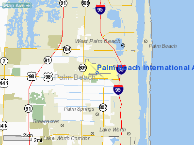
Palm Beach International Airport (IATA: PBI, ICAO: KPBI, FAA LID: PBI) is a public airport located 3 nautical miles (5.6 kilometers) west of Palm Beach, Florida in West Palm Beach, Florida and serves Palm Beach County. The airport is operated and maintained by Palm Beach County Department of Airports. Road access to the airport is available directly from I-95, Southern Boulevard, and Congress Avenue. The airport is bordered to the west by Military Trail. History
- For the military use of the Airport, see Palm Beach Air Force Base
Palm Beach International Airport (PBIA) began operations as Morrison Field in 1936. Morrison Field was named in honour of Miss Grace K. Morrison who was a key participant in the planning and organization of the airfield. The first flight departing the field was a New York bound Eastern Air Lines DC-2 in 1936. The airport was officially dedicated on December 19, 1936.
In 1937, the airport was expanded beyond an airstrip and an administration building when the Palm Beach Aero Corporation obtained a lease, built hangars and the first terminal on the south side of the airport. The new terminal became known as the Eastern Air Lines Terminal. The field was used by the U.S. Army Air Corps during World War II, commencing in 1941. Following the attack on Pearl Harbor Morrison field was used as a base for the allied invasion of France, many planes took off from Morrison, en route to the United Kingdom, to take part in the D-Day invasion of Normandy.
In 1947, the Army Air Corps moved to Mobile, Alabama and commercial services by Eastern and National Airlines resumed from Morrison Field. On August 11, 1948, the name of the airport was changed to Palm Beach International Airport. The airport was once again used by the military in 1951. Renamed Morrison Air Force Base, the facility was used to train nearly 23,000 airmen during the Korean War. In March 1953, the county opened the airport's second passenger terminal on the south side of the field. Following the Korean War, the federal government attempted to make Morrison AFB a permanent military installation, however the County fought the move and took over airport operations in 1959. Delta Air Lines began scheduled service in 1959 and was followed by Capital Airlines in 1960. Jet-powered flights were introduced by Eastern Airlines in 1959 with the turboprop Lockheed L-188 Electra.
In October 1966, a jet-age eight-gate Main Terminal Building was opened on the northeast quadrant of the airport. In 1974, Delta Air Lines moved into its own six-gate unit terminal which featured the airport's first jetways. The FAA built a new ATC Control Tower on the south side of the airport during this period.
On October 23, 1988, the 25-gate David McCampbell Terminal, named for World War II naval flying ace, Medal of Honor recipient and Palm Beach County resident CAPT David McCampbell, USN (Ret) was officially dedicated. The 550,000 square foot (51,000 m²) terminal was designed with expansion in mind and can be doubled in size when required.
In 2003, its terminal was voted among the finest in the nation by the readers of Conde Nast Traveler Magazine. In that same year, a new landscaped and state of the art I-95 interchange was built to decrease traffic on Southern Blvd (US 98) extending Turnage Boulevard (the road around the perimeter of the concourse).
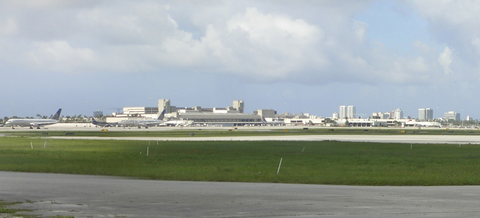
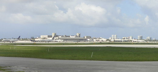
Aggressive competition for the southern end of the airport's market from rapidly expanding Fort Lauderdale/Hollywood International Airport led to an unanticipated stagnation of passenger growth at the airport throughout the 1990s. The 2001 recession and the September 11th terrorist attacks further inhibited growth in 2001 and 2002. However, rapid development in South Florida since 2002 has finally led to a surge of passenger traffic at the airport. In addition, discount carriers such as JetBlue decided to make PBIA a mini-hub for travellers from the northeast during this period, further increasing traffic at the airport. In 2006, the County embarked on an interim expansion program by breaking ground on a new 7 story parking garage and the addition of 3 gates within Concourse C. Long range expansions include an expansion of gates at Concourse B and the eventual construction of a new 14 gate Concourse D to be extended east from the present terminal. A panorama of Palm Beach International Airport, taken from what was the 391st Bomb Group Restaurant off of Southern Boulevard.Annual passenger counts
Enplaning and deplaning combined.
2009 - 5,994,606
2008 - 6,476,303
2007 - 6,936,449
2006 - 6,824,789
2005 - 7,014,237
2004 - 6,537,263
2003 - 6,010,820
2002 - 5,483,662
2001 - 5,934,904
2000 - 5,842,594
1999 - 5,742,634
1998 - 5,899,482
1997 - 5,813,361
1996 - 5,680,913
1995 - 5,418,831
1994 - 5,588,540
1993 - 5,074,132
1992 - 5,023,963
1991 - 5,077,573
1990 - 5,691,410
Facilities
Palm Beach International Airport covers 2,120 acres (858 ha) and has three runways:
- Runway 10L/28R: 10,008 x 150 ft. (3,050 x 46 m), Surface: Asphalt
- Runway 10R/28L: 3,213 x 75 ft. (979 x 23 m), Surface: Asphalt
- Runway 14/32: 6,931 x 150 ft. (2,113 x 46 m), Surface: Asphalt
On December 17, 2009, the runway designations were changed, the former runway designations were:
- Runway 9L/27R: 10,008 x 150 ft. (3,050 x 46 m), Surface: Asphalt
- Runway 9R/27L: 3,213 x 75 ft. (979 x 23 m), Surface: Asphalt
- Runway 13/31: 6,931 x 150 ft. (2,113 x 46 m), Surface: Asphalt
Air traffic control tower
A new 240-foot (73 m) Air Traffic Control tower is currently under construction on the north side of the airport (west of concourse A, off Belvedere Rd.) along with a single-story, 9,000-square-foot (840 m) ATBM Base Building. The current tower lies on the southern side of the airport.
Helicopters
- Helicopter operations typically use 10R/28L or its parallel taxiways, or make a direct approach to either Customs or the Galaxy Aviation ramp.
- Palm Beach County Sheriffs Office (PBSO) maintains its air division from a hangar at the southwest corner of the airport.
- Health Care District of Palm Beach County operates the Traumahawk with Palm Beach County Fire-Rescue from a hangar at the southwest corner of the airport, next to PBSO.
Other hangars
- General Aviation FBO's and hangars are located along the southern edge of the airport, with entrance access available by the Jet Aviation FBO.
Fire protection and emergency medical services
The Palm Beach County Fire-Rescue Aviation Battalion is located between runways at PBI. The battalion is made up of 3 shifts of Aviation Firefighters, Florida Paramedics, a shift Lieutenant and District Chief. The Aviation Battalion Chief oversees all aspects in the battalion. The battalion is responsible for Emergency Medical Services and fire protection for the entire airport.
There is 1 Rescue/Pumper unit (ambulance/mini-pumper), 4 Airport Crash Trucks, 1 mobile command unit, 1 support truck (with backboards, body bags, air bottles, etc.), 1 airplane stair truck, and 3 Battalion Officer vehicles in the Battalion.
Concourses, airlines, and destinations
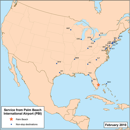 | |
Destinations with direct service from PBI |
The following airlines fly to Palm Beach International Airport:
| Airlines |
Destinations |
Concourse |
| Air Canada |
Newark, Montreal-Trudeau [seasonal; begins December 19], Toronto-Pearson [seasonal] |
B |
| Air France |
Atlanta |
C |
| AirTran Airways |
Atlanta, Baltimore [seasonal], White Plains |
B |
| Alaska Airlines |
Atlanta |
C |
| Alitalia Airlines |
Atlanta |
C |
| American Airlines |
Chicago-O'Hare, Dallas/Fort Worth |
C |
| Bahamasair |
Marsh Harbour |
A |
| Continental Airlines |
Cleveland, Houston-Intercontinental, Newark |
B |
| Continental Connection operated by Gulfstream International Airlines |
Marsh Harbour, Tallahassee |
A |
| Continental Express operated by ExpressJet Airlines |
Cleveland, Houston-Intercontinental |
B |
| Copa Airlines |
Houston |
B |
| Delta Air Lines |
Atlanta, Detroit, Hartford/Springfield [resumes November 19], New York-LaGuardia |
C |
| Direct Air |
Chicago-Rockford [begins November 18], Kalamazoo [begins November 18], Niagara Falls [begins November 18], Punta Cana [begins December 18], San Juan [begins December 16], Worcester [begins November 18] |
TBA |
| JetBlue Airways |
Boston, New York-JFK, New York-LaGuardia, Newark, White Plains |
C |
| KLM |
Atlanta |
C |
| Lufthansa |
Boston, Charlotte, Newark |
B |
| Southwest Airlines |
Baltimore, Hartford/Springfield [begins March 12], Long Island/Islip, Philadelphia, Tampa |
B |
| Spirit Airlines |
Detroit [seasonal], Atlantic City [seasonal] |
C |
| US Airways |
Charlotte, Philadelphia, Washington-Reagan |
B |
| US Airways Express operated by Republic Airlines |
Washington-Reagan |
B |
Public transportation
Palm Tran buses #40 and #44 serve the airport. Both provide connections to the West Palm Beach Tri-Rail/Amtrak/Greyhound station.
In popular culture
Palm Beach International Airport was used in Police Academy 5: Assignment Miami Beach. The airport is about 70 miles (110 km) from Miami, the focal point of the film. This fact is proven in the film as a floor mat with the large letters 'PBIA' printed upon it can be plainly seen.
Controversies
In conjunction with the slated construction of a new ATC tower at PBIA, the FAA intended to transfer all of PBIA's air traffic controllers whose assigned sector is between 5 and 40 miles (60 km) from the airport to a remote facility at Miami International Airport. Ground traffic controllers, and approach controllers whose sector is within 5 miles (8 km) of the runway would have remained at PBIA. The FAA cited the move as a cost cutting measure, but critics say that it creates a risk to South Florida air traffic if the Miami facility is damaged in a hurricane, or terrorist attack. The National Air Traffic Controllers Association opposed the move. The remote facility at Miami International Airport currently houses air traffic controllers for both Miami and Fort Lauderdale international airports.
Donald Trump sued to block the expansion of one of the runways at PBIA.
Incidents involving PBI
- On September 12, 1980, a Florida Commuter Airlines Douglas DC-3 crashed into the Atlantic Ocean on route to Freeport International Airport from Palm Beach International Airport. There were no survivors.
- On January 30, 2008, American Airlines Flight 1738, a Boeing 757 flying from Luis Muñoz Marín International Airport in San Juan, Puerto Rico to Philadelphia International Airport, had to make an emergency landing in West Palm Beach after the captain reported smoke in the cockpit. Of the 137 passengers and seven crewmembers, one passenger and five crewmembers were taken to the hospital, including the captain and the first officer.
- On February 22, 2008, American Airlines Flight 862, a McDonnell Douglas MD-80 flying from Palm Beach International Airport to O'Hare International Airport in Chicago, was diverted to Miami International Airport for an emergency landing due to nose gear trouble. Of the 130 passengers on board there were no injuries reported.
- On March 12, 2009, best-selling author and international leadership guru, John Maxwell, was arrested at Palm Beach International for trying to board a plane with a concealed weapon. According to the report, the TSA screener noticed a handgun displayed inside Maxwell's briefcase. Maxwell told TSA officials that the gun was recently given to him as a gift and that he had simply forgotten to take it out of the briefcase. He was charged with possession of a concealed weapon while attempting to board an airplane and was released from jail on bond. The charges were eventually dropped and his record was cleared. Maxwell addressed the incident on his personal website [1], calling it "one of the stupidest things" he has ever done.
The above content comes from Wikipedia and is published under free licenses – click here to read more.
Location
& QuickFacts
|
FAA Information Effective: |
2007-01-18 |
|
Airport
Identifier: |
PBI |
|
Airport
Status: |
Operational |
|
Longitude/Latitude: |
080-05-44.1210W/26-40-59.3780N
-80.095589/26.683161 (Estimated) |
|
Elevation: |
19 ft / 5.79 m (Surveyed) |
|
Land: |
2120 acres |
|
From
nearest city: |
3 nautical miles W of West Palm Beach, FL |
|
Location: |
Palm Beach County, FL |
|
Magnetic Variation: |
03W (1985) |
Owner
& Manager
|
Ownership: |
Publicly owned |
|
Owner: |
Palm Beach County |
|
Address: |
Bldg 846-palm Beach Intl
West Palm Beach, FL 33406 |
|
Phone
number: |
561-471-7420 |
|
Manager: |
Bruce V Pelly |
|
Address: |
Bldg 846-palm Beach Intl
West Palm Beach, FL 33406 |
|
Phone number: |
561-471-7412 |
Airport
Operations and Facilities
|
Airport Use: |
Open to public |
|
Wind
indicator: |
Yes |
|
Segmented
Circle: |
No |
|
Control
Tower: |
Yes |
|
Lighting
Schedule: |
DUSK-DAWN |
|
Beacon
Color: |
Clear-Green (lighted land airport) |
|
Landing
fee charge: |
No |
|
Sectional
chart: |
Miami |
|
Region: |
ASO - Southern |
|
Boundary
ARTCC: |
ZMA - Miami |
|
Tie-in
FSS: |
MIA - Miami |
|
FSS
on Airport: |
No |
|
FSS
Phone: |
305-233-2600 |
|
FSS
Toll Free: |
1-800-WX-BRIEF |
|
NOTAMs
Facility: |
PBI (NOTAM-d service avaliable) |
|
Certification type/date: |
I D S 04/2005 |
|
Federal Agreements: |
NGPY |
Airport
Communications
Airport
Services
|
Fuel available: |
100LLA |
|
Airframe Repair: |
MAJOR |
|
Power Plant Repair: |
MAJOR |
|
Bottled
Oxygen: |
HIGH/LOW |
|
Bulk
Oxygen: |
HIGH/LOW |
|
Runway
Information
Runway 09L/27R
|
Dimension: |
10008 x 150 ft / 3050.4 x 45.7 m |
|
Surface: |
ASPH, Good Condition |
|
Surface
Treatment: |
Saw-cut or plastic Grooved |
|
Weight
Limit: |
Single wheel: 85000 lbs.
Dual wheel: 200000 lbs.
Dual
tandem wheel: 400000 lbs. |
|
Edge
Lights: |
High |
|
|
Runway 09L |
Runway 27R |
|
Longitude: |
080-06-30.1600W |
080-04-39.9600W |
|
Latitude: |
26-40-59.5500N |
26-40-54.7400N |
|
Elevation: |
19.00
ft |
16.00
ft |
|
Alignment: |
93 |
127 |
|
ILS
Type: |
ILS |
LOC/GS |
|
Traffic
Pattern: |
Left |
Left |
|
Markings: |
Precision instrument, Good Condition |
Precision instrument, Good Condition |
|
Displaced
threshold: |
1200.00 ft |
811.00 ft |
|
VASI: |
4-light PAPI on right side |
4-light PAPI on left side
PAPI OTS INDEFLY. |
|
RVR
Equipment: |
touchdown, rollout |
touchdown, rollout |
|
Approach
lights: |
MALSR |
|
|
Runway
End Identifier: |
|
Yes |
|
Centerline
Lights: |
No |
No |
|
Decleard
distances: |
Take off run available 10000.00 ft
Take off distance available 10000.00 ft
Actual stop distance available 10000.00 ft
Landing distance available 8800.00 ft |
Take off run available 10000.00 ft
Take off distance available 10000.00 ft
Actual stop distance available 10000.00 ft
Landing distance available 9189.00 ft |
|
Runway 09R/27L
|
Dimension: |
3213 x 75 ft / 979.3 x 22.9 m |
|
Surface: |
ASPH, Good Condition |
|
Weight
Limit: |
Single wheel: 25000 lbs. |
|
Edge
Lights: |
Medium |
|
|
Runway 09R |
Runway 27L |
|
Longitude: |
080-06-22.6390W |
080-05-47.2603W |
|
Latitude: |
26-40-52.2835N |
26-40-50.7353N |
|
Elevation: |
16.00
ft |
13.00
ft |
|
Alignment: |
93 |
127 |
|
Traffic
Pattern: |
Right |
Left |
|
Markings: |
Basic, Good Condition |
Basic, Good Condition |
|
VASI: |
4-light PAPI on left side |
4-light PAPI on right side |
|
Decleard
distances: |
Take off run available 3213.00 ft
Take off distance available 3213.00 ft
Actual stop distance available 3213.00 ft
Landing distance available 3213.00 ft |
Take off run available 3213.00 ft
Take off distance available 3213.00 ft
Actual stop distance available 3213.00 ft
Landing distance available 3213.00 ft |
|
Runway 13/31
|
Dimension: |
6931 x 150 ft / 2112.6 x 45.7 m |
|
Surface: |
ASPH, Good Condition |
|
Surface
Treatment: |
Saw-cut or plastic Grooved |
|
Weight
Limit: |
Single wheel: 100000 lbs.
Dual wheel: 180000 lbs.
Dual tandem wheel: 325000 lbs.
Dual dual tandem wheel: 400000 lbs. |
|
Edge
Lights: |
Medium |
|
|
Runway 13 |
Runway 31 |
|
Longitude: |
080-06-14.4827W |
080-05-20.6156W |
|
Latitude: |
26-41-30.5957N |
26-40-41.9065N |
|
Elevation: |
17.00
ft |
16.00
ft |
|
Alignment: |
127 |
127 |
|
Traffic
Pattern: |
Left |
Left |
|
Markings: |
Non-precision instrument, Good Condition |
Non-precision instrument, Good Condition |
|
Crossing
Height: |
67.00 ft |
0.00
ft |
|
Displaced
threshold: |
0.00
ft |
428.00 ft |
|
VASI: |
4-light PAPI on right side |
4-light PAPI on left side |
|
Visual
Glide Angle: |
3.00� |
0.00� |
|
Runway
End Identifier: |
Yes |
Yes |
|
Centerline
Lights: |
No |
No |
|
Obstruction: |
84 ft trees, 3000.0 ft from runway, 150 ft
right of centerline, 33:1 slope to clear |
32 ft road, 200.0 ft from runway, 250 ft left
of centerline
APCH RATIO 38:1 FM DSPLCD THLD; TREES 2118 FT OUT & 375
FT L. |
|
Decleard
distances: |
Take off run available 6931.00 ft
Take off distance available 6931.00 ft
Actual stop distance available 6931.00 ft
Landing distance available 6931.00 ft |
Take off run available 6931.00 ft
Take off distance available 6931.00 ft
Actual stop distance available 6931.00 ft
Landing distance available 6503.00 ft |
|
Radio Navigation
Aids
|
ID |
Type |
Name |
Ch |
Freq |
Var |
Dist |
|
PB |
NDB |
Rubin |
|
356.00 |
03W |
6.2 nm |
|
UTX |
NDB |
United |
|
405.00 |
03W |
18.7 nm |
|
FX |
NDB |
Praiz |
|
221.00 |
02W |
31.8 nm |
|
PJN |
NDB |
Plantation |
|
242.00 |
03W |
33.8 nm |
|
FLL |
VOR/DME |
Fort Lauderdale |
091X |
114.40 |
00E |
36.7 nm |
|
PBI |
VORTAC |
Palm Beach |
104X |
115.70 |
03W |
0.5 nm |
|
PHK |
VORTAC |
Pahokee |
101X |
115.40 |
00E |
32.5 nm |
|
PBI |
VOT |
Palm Beach |
|
109.00 |
|
0.5 nm |
Remarks
- MIGRATORY
BIRDS ON AND INVOF ARPT.
- BE
ALERT: TWY L IS LCTD BTWN RYS 09L/27R & 09R/27L. TWY L IS WIDER
AND LONGER THAN RY 09R/27L - DO NOT CONFUSE TWY L FOR RY.
- HOLD
POSITION SIGN RY 13/31 TWY E UNLIT.
- CRANE
163 FT MSL 2000 FT S RY 09L 1500 FT SW RY 09R.
- NOISE
ABATEMENT PROCEDURES IN EFFECT CALL (561) 471-7467.
- ULTRALIGHT
ACTIVITY INVOF ARPT.
- PORTIONS
OF TWY 'F' S OF TWY 'G' TO AER RY 31 NOT VSB FM ATCT DUE TO BLDGS &
PARKED ACFT.
- BE
ALERT; RYS 27L & 27R THLDS STAGGERED BY 5400 FT.
- RY
9R/27L NON-AIR CARRIER ACFT ONLY.
- AEROBATIC
AREA 3500 BLO 1 NM PBI DAILY INDEFLY.
- 146
FT CRANE 2000 FT S RY 09L AND 1500 FT SW RY 09R.
Based Aircraft
|
Aircraft
based on field: |
116 |
|
Single
Engine Airplanes: |
18 |
|
Multi
Engine Airplanes: |
23 |
|
Jet Engine
Airplanes: |
57 |
|
Helicopters: |
18 |
Major Carriers
Serving This Airport
| Delta Air Lines Inc. |
20.8% |
| US Airways Inc. |
17.5% |
| JetBlue Airways |
16.4% |
| Southwest Airlines Co. |
16.3% |
| Continental Air Lines Inc. |
10.6% |
| AirTran Airways Corporation |
6.2% |
| Expressjet Airlines Inc. |
4.0% |
| American Airlines Inc. |
2.7% |
| Comair Inc. |
2.6% |
| Northwest Airlines Inc. |
1.5% |
Most Popular Destinations
|
Hartsfield - Jackson Atlanta Intl (ATL) |
15.8% |
|
John F Kennedy Intl (JFK) |
12.0% |
| Newark Liberty Intl (EWR) |
9.4% |
| Charlotte/douglas Intl (CLT) |
7.8% |
| Philadelphia Intl (PHL) |
6.4% |
|
Baltimore/washington Intl Thurgood Marshal (BWI) |
5.3% |
| Tampa Intl (TPA) |
5.3% |
| La Guardia (LGA) |
5.2% |
|
George Bush Intercontinental/houston (IAH) |
5.2% |
|
General Edward Lawrence Logan Intl (BOS) |
5.0% |
Most Popular Aircraft
|
N445US |
0.6% |
| N640DL |
0.5% |
|
N417US |
0.5% |
| N421US |
0.5% |
|
N451UW |
0.5% |
| N460UW |
0.5% |
|
N433US |
0.5% |
| N423US |
0.5% |
|
N425US |
0.5% |
| N449US |
0.4% |
Operational Statistics
Time Period: 2005-07-01
- 2006-06-30
|
Aircraft
Operations: |
548/Day |
|
Commerical: |
30.5% |
|
Air Taxi: |
19.3% |
|
General
Aviation Local: |
1.7% |
|
General
Aviation Itinerant: |
48.0% |
|
Military: |
0.6% |
Palm Beach International Airport
Address:
Palm Beach County, FL
Tel:
561-471-7420,
561-471-7412
Images
and information placed above are from
http://www.airport-data.com/airport/PBI/
We
thank them for the data!
| General
Info |
| Country |
United
States |
| State |
FLORIDA
|
| FAA ID |
PBI
|
| Latitude |
26-40-59.378N
|
| Longitude |
080-05-44.121W
|
| Elevation |
19 feet
|
| Near City |
WEST PALM
BEACH |
We don't guarantee the information is fresh and accurate. The data may
be wrong or outdated.
For more up-to-date information please refer to other sources.
|
|