|
|
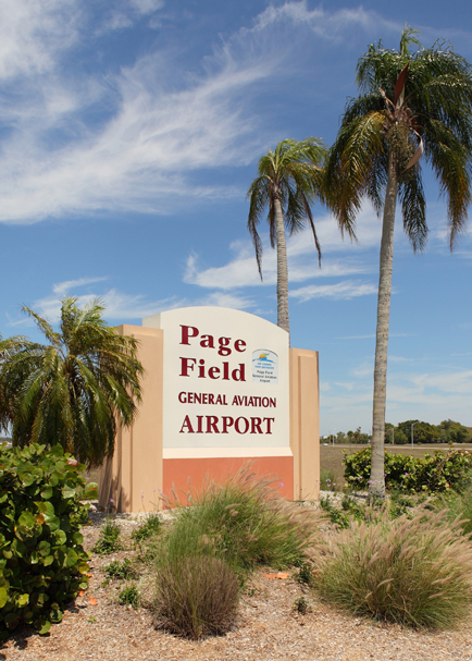
| Page Field General Aviation Airport |
 |
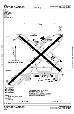 |
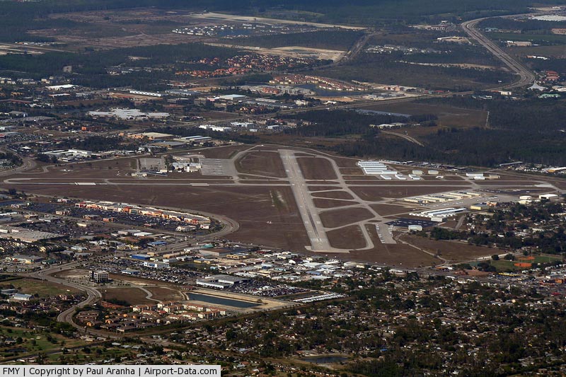
| FAA airport diagram |
| IATA: FMY – ICAO: KFMY – FAA LID: FMY |
| Summary |
| Airport type |
Public |
| Owner |
Lee County Port Authority |
| Location |
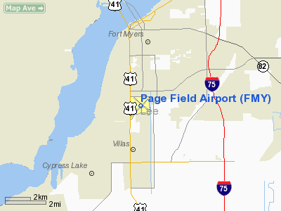
Lee County, near Fort Myers, Florida |
| Elevation AMSL |
17 ft / 5 m |
| Website |
http://www.flyfmy.com |
| Runways |
| Direction |
Length |
Surface |
| ft |
m |
| 5/23 |
6,406 |
1,953 |
Asphalt |
| 13/31 |
4,912 |
1,497 |
Asphalt |
| Statistics (2009) |
| Aircraft operations |
75,765 |
| Source: Lee County Port Authority |
Coordinates: 26°35′12″N 081°51′48″W / 26.58667°N 81.86333°W / 26.58667; -81.86333  | |
Page Field General Aviation Airport (FMY) |
Page Field General Aviation Airport (IATA: FMY, ICAO: KFMY, FAA LID: FMY) is a public airport located three miles (5 km) south of the central business district of Fort Myers, a city in Lee County, Florida, United States. It is owned by the Lee County Port Authority. Facilities and aircraft
 | |
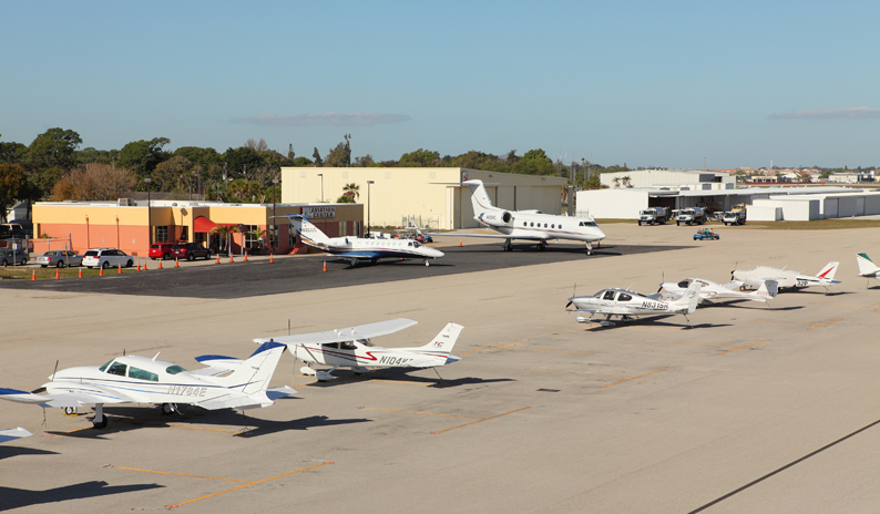
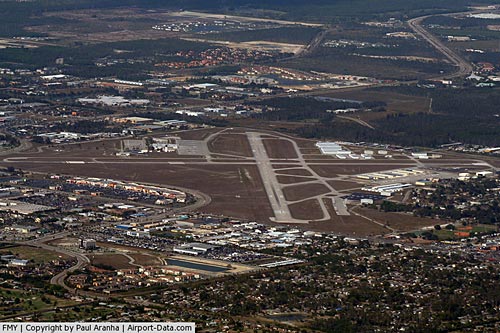
FMY Ramp |
Page Field covers an area of 670 acres (271 ha) which contains two asphalt paved runways: 5/23 measuring 6,406 x 150 ft (1,953 x 46 m) and 13/31 measuring 4,912 x 150 ft (1,497 x 46 m).
For the 12-month period ending December 31, 2009, the airport had 75,765 aircraft operations, an average of 207 per day.
In May 2010, construction of a new terminal building began on the west side of Page Field. Once completed, the new terminal will replace the existing facility and will include a two-story, 22,613-square-foot (2,100.8 m) building, a 24,000-square-foot (2,200 m) multi-use hangar, parking lot and a new Fuel Farm with jet and AvGas fuel. The estimated total economic impact will be $28 million. The total project cost is $16.2 million and will support 300 jobs.
History
Constructed in 1927 as a civilian airport, Page Field was appropriated by the War Department at the beginning of World War II. Renamed Fort Myers Army Air Field, it was used by the United States Army Air Force's Third Air Force for both antisubmarine patrols and conventional bomber training in the B-24 Liberator. The facility was returned to the civilian control of the State of Florida and then Lee County shortly following the end of World War II.
Page Field later hosted domestic commercial air service for the greater Fort Myers area. In the 1950s, the army barracks were replaced with a small terminal, which was expanded in 1960. A new terminal was built in the mid-1970s on the north side of Page Field. With deregulation of the airline industry in 1978, the terminal facilities and airfield could no longer handle the increased demand for air transportation to and from Southwest Florida. Commercial traffic was transferred to Southwest Florida Regional Airport, known today as Southwest Florida International Airport (RSW), in 1983. Page Field now serves as a designated FAA reliever airport for RSW and accommodates only general aviation traffic.
Awards
- Florida Department of Transportation named Page Field the General Aviation Airport of the Year in 2008
The above content comes from Wikipedia and is published under free licenses – click here to read more.
|
 |
(Click on the photo to enlarge) |
Location
& QuickFacts
|
FAA Information Effective: |
2007-01-18 |
|
Airport
Identifier: |
FMY |
|
Airport
Status: |
Operational |
|
Longitude/Latitude: |
081-51-47.7000W/26-35-11.8000N
-81.863250/26.586611 (Estimated) |
|
Elevation: |
17 ft / 5.18 m (Surveyed) |
|
Land: |
670 acres |
|
From
nearest city: |
3 nautical miles S of Fort Myers, FL |
|
Location: |
Lee County, FL |
|
Magnetic Variation: |
03W (1990) |
Owner
& Manager
|
Ownership: |
Publicly owned |
|
Owner: |
Lee County Port Authority |
|
Address: |
16000 Chamberlin Pkwy Se
Fort Myers, FL 33913 |
|
Phone
number: |
239-768-1000 |
|
Manager: |
Coleen Baker |
|
Address: |
501 Danley Dr
Fort Myers, FL 33907 |
|
Phone number: |
239-936-1443 |
Airport
Operations and Facilities
|
Airport Use: |
Open to public |
|
Wind
indicator: |
Yes |
|
Segmented
Circle: |
No |
|
Control
Tower: |
Yes |
|
Lighting
Schedule: |
DUSK-DAWN |
|
Beacon
Color: |
Clear-Green (lighted land airport) |
|
Landing
fee charge: |
Yes
FEES FOR ALL CHARTER AND REVENUE PRODUCING ACFT. |
|
Sectional
chart: |
Miami |
|
Region: |
ASO - Southern |
|
Boundary
ARTCC: |
ZMA - Miami |
|
Tie-in
FSS: |
MIA - Miami |
|
FSS
Phone: |
305-233-2600 |
|
FSS
Toll Free: |
1-800-WX-BRIEF |
|
NOTAMs
Facility: |
FMY (NOTAM-d service avaliable) |
|
Federal Agreements: |
NGPRY3 |
Airport
Communications
Airport
Services
|
Fuel available: |
100LLA |
|
Airframe Repair: |
MAJOR |
|
Power Plant Repair: |
MAJOR |
|
Bottled
Oxygen: |
NONE |
|
Runway Information
Runway 05/23
|
Dimension: |
6406 x 150 ft / 1952.5 x 45.7 m |
|
Surface: |
ASPH, Good Condition |
|
Surface
Treatment: |
Saw-cut or plastic Grooved |
|
Weight
Limit: |
Single wheel: 125000 lbs.
Dual wheel: 155000 lbs.
Dual
tandem wheel: 350000 lbs. |
|
Edge
Lights: |
Medium |
|
|
Runway 05 |
Runway 23 |
|
Longitude: |
081-52-15.9400W |
081-51-23.6140W |
|
Latitude: |
26-34-48.0296N |
26-35-30.5970N |
|
Elevation: |
13.00
ft |
17.00
ft |
|
Alignment: |
48 |
127 |
|
ILS
Type: |
ILS |
|
|
Traffic
Pattern: |
Left |
Left |
|
Markings: |
Precision instrument, Good Condition |
Precision instrument, Fair Condition |
|
Crossing
Height: |
52.00 ft |
55.00 ft |
|
Displaced
threshold: |
459.00 ft |
399.00 ft |
|
VASI: |
4-box on left side |
4-box on left side |
|
Visual
Glide Angle: |
3.00� |
3.00� |
|
Obstruction: |
24 ft bldg, 353.0 ft from runway, 6:1 slope
to clear
RY 05 APCH SLOPE TO DSPLCD THLD 34:1.
RY
05 HAS 8 FT FENCE 192 FT FROM RY END. |
23 ft rr, 200.0 ft from runway, 420 ft left
of centerline
RY 23 APCH SLOPE 26:1 TO DSPLCD THR.
RR 190 FT FROM END OF RY, 495 FT L OF CNTRLN. |
|
Decleard
distances: |
Take off run available 6401.00 ft
Take off distance available 6401.00 ft
Actual stop distance available 6401.00 ft
Landing distance available 5947.00 ft |
Take off run available 6401.00 ft
Take off distance available 6401.00 ft
Actual stop distance available 6401.00 ft
Landing distance available 6001.00 ft |
|
Runway 13/31
|
Dimension: |
4912 x 150 ft / 1497.2 x 45.7 m |
|
Surface: |
ASPH, Good Condition |
|
Weight
Limit: |
Single wheel: 30000 lbs.
Dual wheel: 35000 lbs. |
|
Edge
Lights: |
Medium |
|
|
Runway 13 |
Runway 31 |
|
Longitude: |
081-52-05.5334W |
081-51-24.3841W |
|
Latitude: |
26-35-30.8670N |
26-34-59.2861N |
|
Elevation: |
14.00
ft |
15.00
ft |
|
Alignment: |
127 |
127 |
|
Traffic
Pattern: |
Left |
Left |
|
Markings: |
Non-precision instrument, Fair Condition |
Non-precision instrument, Fair Condition |
|
Crossing
Height: |
30.00 ft |
39.00 ft |
|
Displaced
threshold: |
615.00 ft |
0.00
ft |
|
VASI: |
4-box on left side |
4-box on left side |
|
Visual
Glide Angle: |
3.00� |
3.00� |
|
Obstruction: |
29 ft pline, 240.0 ft from runway, 125 ft left
of centerline, 1:1 slope to clear
RY 13 APCH SLOPE 29:1 TO DSPLCD THLD DUE TO 29 FT LGT POLE
860 FT 125 FT L.
8 FT BLAST FENCE & ROAD END OF RY. |
8 ft fence, 260.0 ft from runway, 250 ft right
of centerline, 7:1 slope to clear
APCH RATIO 23:1 TO END OF RY DUE TO 25 FT TREES, 575 FT FROM
END OF RY. |
|
Decleard
distances: |
Take off run available 4909.00 ft
Take off distance available 4909.00 ft
Actual stop distance available 4909.00 ft
Landing distance available 4297.00 ft |
Take off run available 4667.00 ft
Take off distance available 4909.00 ft
Actual stop distance available 4667.00 ft
Landing distance available 4667.00 ft |
|
Radio Navigation
Aids
|
ID |
Type |
Name |
Ch |
Freq |
Var |
Dist |
|
APF |
NDB |
Naples |
|
201.00 |
03W |
26.3 nm |
|
VNC |
NDB |
Venice |
|
206.00 |
02W |
41.7 nm |
|
PGD |
VOR |
Punta Gorda |
|
110.20 |
03W |
21.0 nm |
|
CYY |
VOR/DME |
Cypress |
023X |
108.60 |
03W |
26.4 nm |
|
RSW |
VORTAC |
Lee County |
055X |
111.80 |
02W |
5.8 nm |
|
LBV |
VORTAC |
La Belle |
041X |
110.40 |
01E |
29.2 nm |
Remarks
- HIGH
DENSITY BIRD POPULATION WITHIN THE ARPT BOUNDARIES.
- BRIGHTLY
LGTD BALL FIELD 1500 FT SE OF AER 05.
- NOISE
SENSITIVE AIRPORT - VOLUNTARY RESTRICTION FOR LARGE AIRCRAFT AND JET
AIRCRAFT CONDUCTING MULTIPLE APPROACHES AND/OR CLOSED TRAFFIC.
- TWY
'B' SE OF TWY 'A' IS NON-MOVEMENT AREA NOT VSB FM ATCT.
- PAEW
ADJ TO RYS & TWYS DURING DALGT HRS.
- NO
SKED COML PSGN OPNS. FOR
INFO CALL AMGR 239-936-1443.
- TWY
A3 CLSD BTN TWYS D1 & D2 INDEFLY.
Based Aircraft
|
Aircraft
based on field: |
220 |
|
Single
Engine Airplanes: |
200 |
|
Multi
Engine Airplanes: |
14 |
|
Jet Engine
Airplanes: |
2 |
|
Helicopters: |
4 |
Operational Statistics
Time Period: 1998-08-27
- 1999-08-26
|
Aircraft
Operations: |
260/Day |
|
Commerical: |
0.0% |
|
Air Taxi: |
4.6% |
|
General
Aviation Local: |
43.0% |
|
General
Aviation Itinerant: |
52.2% |
|
Military: |
0.2% |
Page Field Airport
Address:
Lee County, FL
Tel:
239-768-1000,
239-936-1443
Images
and information placed above are from
http://www.airport-data.com/airport/FMY/
We
thank them for the data!
| General
Info |
| Country |
United
States |
| State |
FLORIDA
|
| FAA ID |
FMY
|
| Latitude |
26-35-11.800N
|
| Longitude |
081-51-47.700W
|
| Elevation |
17 feet
|
| Near City |
FORT MYERS
|
We don't guarantee the information is fresh and accurate. The data may
be wrong or outdated.
For more up-to-date information please refer to other sources.
|
|