 |
|
Ormond Beach Municipal Airport |
Ormond Beach Municipal Airport
Ormond Beach Airport |
 |
| IATA: none – ICAO: KOMN – FAA LID: OMN |
| Summary |
| Airport type |
Public |
| Owner |
City of Ormond Beach |
| Elevation AMSL |
28 ft / 8.5 m |
| Coordinates |
29°18′04″N 81°06′49.7″W / 29.30111°N 81.113806°W / 29.30111; -81.113806 |
| Website |
www.ormondbeach.org |
| Runways |
| Direction |
Length |
Surface |
| ft |
m |
| 8/26 |
4,004 |
1,220 |
Asphalt |
| 17/35 |
3,701 |
1,128 |
Asphalt |
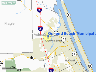
Ormond Beach Airport (ICAO: KOMN, FAA LID: OMN), also known as Ormond Beach Municipal Airport, is a general aviation airport located 3 miles (4.8 km) to the northwest of the city of Ormond Beach in Volusia County, Florida, USA. History
OMN was established in 1943 as Outlying Field Ormond Beach (OLF Ormond Beach), a naval aviation training field supporting operations at Naval Air Station DeLand and Naval Air Station Daytona Beach. Military operations were discontinued at the end of World War II and the airport was deeded to the city by the U.S. Government in 1959 for use as a civilian airport.
Facilities
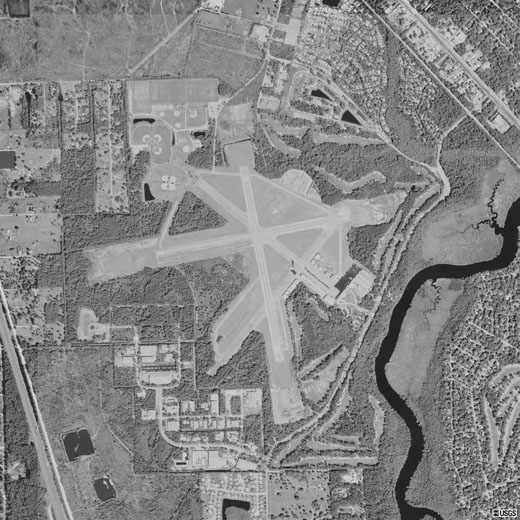
Ormond Beach Airport covers 1,128 acres (456 ha) and has two operational, fully illuminated asphalt runways, 4000 feet and 3701 feet in length, respectively, as well as two closed runways that are 4000 feet in length.
The airfield is home to multiple Fixed Base Operators and aviation service and support companies offering various aviation services such include aviation gasoline and jet fuel, aircraft flight instruction and hire, aircraft servicing and aircraft interior modification and repair, among others. The airport also provides an additional location for flight training operations from nearby Embry-Riddle Aeronautical University at Daytona Beach International Airport.
In 2003, Ormond Beach Municipal Airport received nearly $500,000 dollars as part of the federal Airport Improvement Program (AIP) to help with aviation safety and other airfield improvements. As of 2009, the airport has an operational FAA Level 1 Air Traffic Control Tower under the FAA Contract Tower Program and a 1,000-square foot passenger terminal building, with 45 on-airport parking spaces. There are also about 50 tie-downs for the airport's general aviation aircraft. Between the airport's T-hangars and conventional hangars, there are 150 covered parking spaces for aircraft.
The above content comes from Wikipedia and is published under free licenses – click here to read more.
Location
& QuickFacts
|
FAA Information Effective: |
2007-01-18 |
|
Airport
Identifier: |
OMN |
|
Airport
Status: |
Operational |
|
Longitude/Latitude: |
081-06-49.0000W/29-18-02.0000N
-81.113611/29.300556 (Estimated) |
|
Elevation: |
29 ft / 8.84 m (Surveyed) |
|
Land: |
1128 acres |
|
From
nearest city: |
3 nautical miles NW of Ormond Beach, FL |
|
Location: |
Volusia County, FL |
|
Magnetic Variation: |
02W (1980) |
Owner
& Manager
|
Ownership: |
Publicly owned |
|
Owner: |
City Of Ormond Beach |
|
Address: |
Po Box 277
Ormond Beach, FL 32175 |
|
Phone
number: |
386-676-3224 |
|
Manager: |
Tom Lipps |
|
Address: |
Po Box 277
Ormond Beach, FL 32175 |
|
Phone number: |
386-676-3224
FBO NR 386-677-5724. |
Airport
Operations and Facilities
|
Airport Use: |
Open to public |
|
Wind
indicator: |
Yes |
|
Segmented
Circle: |
Yes |
|
Control
Tower: |
Yes |
|
Lighting
Schedule: |
DUSK-DAWN
ACTVT MIRL RYS 08/26 & 17/35, PAPI RYS 08, 26, 17 &
35, REIL RY 17 - CTAF. |
|
Beacon
Color: |
Clear-Green (lighted land airport) |
|
Landing
fee charge: |
No |
|
Sectional
chart: |
Jacksonville |
|
Region: |
ASO - Southern |
|
Traffic
Pattern Alt: |
1000 ft |
|
Boundary
ARTCC: |
ZJX - Jacksonville |
|
Tie-in
FSS: |
PIE - Saint Petersburg |
|
FSS
on Airport: |
No |
|
FSS
Toll Free: |
1-800-WX-BRIEF |
|
NOTAMs
Facility: |
PIE (NOTAM-d service avaliable) |
|
Federal Agreements: |
NGPY |
Airport
Communications
|
CTAF: |
119.075 |
|
Unicom: |
123.050 |
Airport
Services
|
Fuel available: |
100LLA |
|
Airframe Repair: |
MAJOR |
|
Power Plant Repair: |
MAJOR |
|
Bottled
Oxygen: |
NONE |
|
Runway Information
Runway 08/26
|
Dimension: |
4004 x 75 ft / 1220.4 x 22.9 m |
|
Surface: |
ASPH, Good Condition |
|
Weight
Limit: |
Single wheel: 30000 lbs.
Dual wheel: 40000 lbs. |
|
Edge
Lights: |
Medium
RY LGTS OTS INDEFLY EXCP MED/LOW INTST. |
|
|
Runway 08 |
Runway 26 |
|
Longitude: |
081-07-12.8100W |
081-06-28.4200W |
|
Latitude: |
29-18-03.0300N |
29-18-10.5700N |
|
Elevation: |
29.00 ft |
21.00
ft |
|
Alignment: |
79 |
127 |
|
Traffic
Pattern: |
Left |
Right |
|
Markings: |
Non-precision instrument, Fair Condition |
Non-precision instrument, Fair Condition |
|
Crossing
Height: |
38.00 ft |
38.00 ft |
|
VASI: |
2-light PAPI on left side |
2-light PAPI on left side |
|
Visual
Glide Angle: |
3.00� |
3.00� |
|
Obstruction: |
69 ft trees, 1654.0 ft from runway, 125 ft
right of centerline, 21:1 slope to clear |
53 ft trees, 1063.0 ft from runway, 30 ft right
of centerline, 20:1 slope to clear
20:1 APCH RATIO RY END. |
|
Runway 17/35
|
Dimension: |
3701 x 100 ft / 1128.1 x 30.5 m |
|
Surface: |
ASPH, Good Condition |
|
Weight
Limit: |
Single wheel: 30000 lbs.
Dual wheel: 40000 lbs. |
|
Edge
Lights: |
Medium
RY LGTS OTS INDEFLY EXCP MED/LOW INTST. |
|
|
Runway 17 |
Runway 35 |
|
Longitude: |
081-06-52.7900W |
081-06-44.2100W |
|
Latitude: |
29-18-19.1400N |
29-17-43.2700N |
|
Elevation: |
25.00 ft |
27.00 ft |
|
Alignment: |
127 |
127 |
|
Traffic
Pattern: |
Right |
Left |
|
Markings: |
Non-precision instrument, Fair Condition |
Non-precision instrument, Fair Condition |
|
Crossing
Height: |
38.00 ft |
38.00 ft |
|
VASI: |
2-light PAPI on left side |
2-light PAPI on left side |
|
Visual
Glide Angle: |
3.00� |
3.00� |
|
Runway
End Identifier: |
Yes |
|
|
Obstruction: |
57 ft trees, 1286.0 ft from runway, 82 ft right
of centerline, 22:1 slope to clear |
67 ft trees, 1549.0 ft from runway, 95 ft right
of centerline, 20:1 slope to clear |
|
Radio Navigation
Aids
|
ID |
Type |
Name |
Ch |
Freq |
Var |
Dist |
|
DED |
NDB |
Deland/dcmsnd |
|
201.00 |
05W |
16.3 nm |
|
EVB |
NDB |
New Smyrna Beach |
|
417.00 |
04W |
17.3 nm |
|
SFB |
NDB |
Sanford |
|
408.00 |
05W |
31.7 nm |
|
IAK |
NDB |
Palatka |
|
243.00 |
05W |
42.2 nm |
|
GGL |
NDB |
Geiger Lake |
|
375.00 |
05W |
45.3 nm |
|
LEE |
NDB |
Leesburg |
|
335.00 |
04W |
46.6 nm |
|
TTS |
TACAN |
Kennedy Space Center |
059Y |
|
00E |
46.1 nm |
|
SGJ |
VOR/DME |
St Augustine |
031X |
109.40 |
06W |
41.0 nm |
|
OMN |
VORTAC |
Ormond Beach |
073X |
112.60 |
00E |
0.2 nm |
|
ORL |
VORTAC |
Orlando |
059X |
112.20 |
00E |
47.0 nm |
|
DAB |
VOT |
Daytona Beach |
|
111.00 |
|
7.8 nm |
Remarks
- PORTIONS
OF TWYS CRACKING WITH GRASS GROWING THROUGH.
- NOISE
ABATEMENT PROCEDURES: ALL RYS; FLY RY HDG TO 1000 FT BEFORE PROCEEDING
ON COURSE.
- TREES
IN ALL TRANSITION SFCS AT THE APCH ENDS; THE PRIMARY SFCS ARE 500 FT
WIDE WITH 7:1 TRANSITION SFC ON THE SIDES.
- LINE
OF SIGHT OBSTD BTN RYS 08/26, 17/35.
- TWY
C CLSD INDEFLY.
Based Aircraft
|
Aircraft
based on field: |
169 |
|
Single
Engine Airplanes: |
142 |
|
Multi
Engine Airplanes: |
19 |
|
Jet Engine
Airplanes: |
4 |
|
Helicopters: |
4 |
Operational Statistics
Time Period: 2000-09-12
- 2001-09-11
|
Aircraft
Operations: |
348/Day |
|
Air Taxi: |
0.4% |
|
General
Aviation Local: |
53.7% |
|
General
Aviation Itinerant: |
45.8% |
|
Military: |
0.0% |
Ormond Beach Municipal Airport
Address:
Volusia County, FL
Tel:
386-676-3224
Images
and information placed above are from
http://www.airport-data.com/airport/OMN/
We
thank them for the data!
| General
Info |
| Country |
United
States |
| State |
FLORIDA
|
| FAA ID |
OMN
|
| Latitude |
29-18-04.100N
|
| Longitude |
081-06-49.700W
|
| Elevation |
28 feet
|
| Near City |
ORMOND
BEACH |
We don't guarantee the information is fresh and accurate. The data may
be wrong or outdated.
For more up-to-date information please refer to other sources.
|
|


