 |
|
Orlando Regional Medical Center Heliport |
|
|
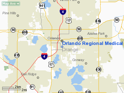
Location
& QuickFacts
|
FAA Information Effective: |
2007-01-18 |
|
Airport
Identifier: |
FD28 |
|
Airport
Status: |
Operational |
|
Longitude/Latitude: |
081-22-37.2510W/28-31-31.0090N
-81.377014/28.525280 (Estimated) |
|
Elevation: |
157 ft / 47.85 m (Estimated) |
|
Land: |
0 acres |
|
From
nearest city: |
1 nautical miles N of Orlando, FL |
|
Location: |
Orange County, FL |
|
Magnetic Variation: |
03W (1985) |
Owner
& Manager
|
Ownership: |
Privately owned |
|
Owner: |
Orlando Rgnl Medical Center |
|
Address: |
1414 South Kuhl Ave
Orlando, FL 32806 |
|
Phone
number: |
407-843-5783 |
|
Manager: |
Joe Bob Pearce |
|
Address: |
1414 South Kuhl Ave
Orlando, FL 32806 |
|
Phone number: |
407-843-5783 |
Airport
Operations and Facilities
|
Airport Use: |
Private
MEDICAL. |
|
Wind indicator: |
Yes |
|
Segmented Circle: |
No |
|
Control Tower: |
No |
|
Lighting Schedule: |
DUSK-DAWN |
|
Beacon Color: |
Clear-Green-Yellow (heliport) |
|
Landing fee charge: |
No |
|
Sectional chart: |
Jacksonville |
|
Region: |
ASO - Southern |
|
Boundary ARTCC: |
ZJX - Jacksonville |
|
Tie-in FSS: |
PIE - Saint Petersburg |
|
FSS on Airport: |
No |
|
FSS Toll Free: |
1-800-WX-BRIEF |
Airport
Services
|
Runway Information
Helipad H1
|
Dimension: |
100 x 42 ft / 30.5 x 12.8 m |
|
Surface: |
CONC,
ROOFTOP. |
|
|
Runway H1 |
Runway |
|
Traffic
Pattern: |
Left |
Left |
|
Radio Navigation
Aids
|
ID |
Type |
Name |
Ch |
Freq |
Var |
Dist |
|
ISM |
NDB |
Kissimmee |
|
329.00 |
05W |
14.5 nm |
|
SFB |
NDB |
Sanford |
|
408.00 |
05W |
17.1 nm |
|
LEE |
NDB |
Leesburg |
|
335.00 |
04W |
28.7 nm |
|
GGL |
NDB |
Geiger Lake |
|
375.00 |
05W |
29.9 nm |
|
DED |
NDB |
Deland/dcmsnd |
|
201.00 |
05W |
33.0 nm |
|
COI |
NDB |
Merritt Island |
|
247.00 |
05W |
38.0 nm |
|
EVB |
NDB |
New Smyrna Beach |
|
417.00 |
04W |
39.2 nm |
|
SQT |
NDB |
Satellite |
|
257.00 |
03W |
44.0 nm |
|
RHZ |
NDB |
Zephyrhills |
|
253.00 |
03W |
45.0 nm |
|
TTS |
TACAN |
Kennedy Space Center |
059Y |
|
00E |
36.5 nm |
|
COF |
TACAN |
Patrick |
097X |
|
04W |
44.0 nm |
|
MLB |
VOR/DME |
Melbourne |
037X |
110.00 |
02W |
46.7 nm |
|
ORL |
VORTAC |
Orlando |
059X |
112.20 |
00E |
2.5 nm |
|
LAL |
VORTAC |
Lakeland |
107X |
116.00 |
01E |
46.8 nm |
|
OMN |
VORTAC |
Ormond Beach |
073X |
112.60 |
00E |
48.8 nm |
|
DAB |
VOT |
Daytona Beach |
|
111.00 |
|
42.9 nm |
Remarks
- CTC
HOSPITAL COMMUNICATION CENTER PRIOR TO LANDING ON 155.340 P.L. 85.4.
- VFR,
PVT USE ONLY.
Based Aircraft
|
Aircraft
based on field: |
1 |
|
Helicopters: |
1 |
Orlando Regional Medical Center Heliport
Address:
Orange County, FL
Tel:
407-843-5783
Images
and information placed above are from
http://www.airport-data.com/airport/FD28/
We
thank them for the data!
| General
Info |
| Country |
United
States |
| State |
FLORIDA
|
| FAA ID |
FD28
|
| Latitude |
28-31-31.009N
|
| Longitude |
081-22-37.251W
|
| Elevation |
157 feet
|
| Near City |
ORLANDO
|
We don't guarantee the information is fresh and accurate. The data may
be wrong or outdated.
For more up-to-date information please refer to other sources.
|
|


