|
|
Opa-locka Airport
Opa-locka Executive Airport |
| IATA: OPF – ICAO: KOPF – FAA LID: OPF |
| Summary |
| Airport type |
Public |
| Owner |
Miami-Dade County |
| Operator |
Miami-Dade Aviation Department (MDAD) |
| Serves |
Miami, Florida |
| Location |
Dade County, Florida |
| Elevation AMSL |
8 ft / 2 m |
| Coordinates |
25°54′25″N 080°16′42″W / 25.90694°N 80.27833°W / 25.90694; -80.27833 |
| Website |
www.miami-airport.com/... |
| Runways |
| Direction |
Length |
Surface |
| ft |
m |
| 9L/27R |
8,002 |
2,439 |
Asphalt |
| 9R/27L |
4,306 |
1,312 |
Asphalt |
| 12/30 |
6,800 |
2,073 |
Asphalt |
| Statistics (2001) |
| Aircraft operations |
149,813 |
| Based aircraft |
291 |
| Source: Federal Aviation Administration |
Opa-locka Airport (IATA: OPF, ICAO: KOPF, FAA LID: OPF), also known as Opa-locka Executive Airport, is a general aviation airport and joint civil-military airfield located 10 miles (16 km) north of the central business district of Miami, in Miami-Dade County, Florida, United States. A portion of the airport is in the city of Opa-locka and a portion is in an unincorporated area.
The airport has a control tower which is manned from 7:00 AM to 9:00 PM. The airport has four fixed base operators. It is owned by Miami-Dade County and operated by the Miami-Dade Aviation Department.
The tenant military activity is Coast Guard Air Station Miami, operating HU-25 Guardian jet aircraft and HH-65 Dolphin helicopters for coastal patrol and air-sea rescue operations. Much of CGAS Miami's facilities were originally built during World War II as part of the former Naval Air Station Miami.
DayJet previously provided an on-demand jet air taxi service from this airport to 44 airports in 5 states. The company filed for Chapter 7 bankruptcy liquidation in 2008.
The airport is currently served by several cargo and charter airlines who use the U.S. customs facility. Maintenance and modification of airliners up to Boeing 747 size is carried out by several aviation firms. History
Aviation pioneer Glenn Curtiss retired from aircraft development and manufacturing in the 1920s and became a real estate developer in Florida. In 1926 he founded the City of Opa-locka, naming it Opa-tisha-woka-locka (quickly shortened to Opa-locka), a Native American name that translates into the high land north of the little river on which there is a camping place.
Adjacent to the city he created the Florida Aviation Camp on a large tract of land, and moved his Glenn Curtiss Aviation School there from its former location close to Biscayne Bay in Miami. He transferred part of the land to the City of Miami, and it became the Miami Municipal Airport. This airport was also known as Glenn Curtiss Field. In 1937 Amelia Earhart started her attempt to circumnavigate the world from this airport. A larger area to the east of Miami Municipal Airport was developed during the 1930s as All-American Airport. The All-American Airport was acquired by the City of Miami around 1938 and renamed "Miami International (Master) Airport". Miami Municipal Airport and Miami International (Master) Airport were purchased from the city by the Federal government in 1942 and added to Naval Air Station Miami (NAS Miami) as Miami Municipal Field and Master Field (later referred to colloquially as "Masters Field"), respectively. Miami Municipal Field was connected to Masters Field by a taxiway that crossed the railroad tracks which separated the two fields. Miami Municipal Field was renamed Amelia Earhart Field in 1947. The All-American Air Races were held at Miami Municipal/Amelia Earhart Field or All-American Airport/Miami International (Master) Airport from 1929 until 1935, and the All-American Air Maneuvers from 1935 until 1941 and from 1946 to 1950.
Shortly before he died in 1930, Curtiss transferred the rest of his Florida Aviation Camp property to the United States Navy. This property became a Naval Reserve Aviation Training Base (NRATB). This station supported both heavier-than-air and lighter-than-air aircraft. The dirigible USS Akron stopped at what became NAS Miami on both legs of its 1933 trip to the Panama Canal Zone, and departed the station less than two weeks before its fatal crash in April 1933. The base was one of the stops on the triangular Germany-Brazil-United States-Germany route of the Graf Zeppelin. Major expansion of the base began in 1939, and it was commissioned as Naval Air Station Miami (NAS Miami) in 1940.
 | |
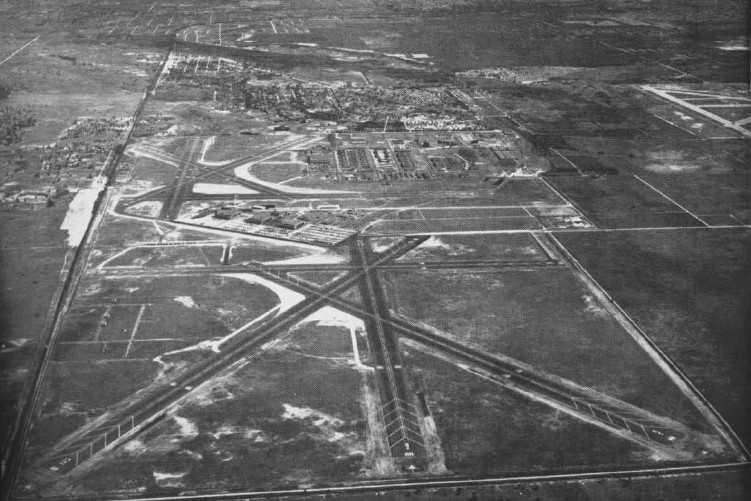
Aerial view of NAS Miami in the mid-1940s |
During World War II, NAS Miami was headquarters for operations of the U.S. Naval Air Training Command, with six training bases. NAS Miami consisted of the original training base, known as Mainside or Opa-Locka, Miami Municipal Field and Master Field. At its peak, the base employed 7,200 officers and men and 3,100 civilians. Activity continued on a reduced basis after the war. Master Field became Marine Corps Air Station Miami (MCAS Miami) circa 1955.. MCAS Miami was closed in 1959, the property was transferred to Dade County, and the Dade County Junior College opened there in 1961. In 1962 the remainder of the NAS property, except for a portion reserved for the U. S. Coast Guard, was transferred to Dade County, and became Opa-locka Airport. In 1965, Coast Guard Air Station Miami transferred its operations from Dinner Key to the Opa-locka Airport.
Some of the 9/11 hijackers trained at the airport.
Facilities and aircraft
Opa-locka Airport covers an area of 1,810 acres (732 ha) which contains three asphalt paved runways: 9L/27R measuring 8,002 x 150 ft (2,439 x 46 m), 9R/27L measuring 4,306 x 100 ft (1,312 x 30 m) and 12/30 measuring 6,800 x 150 ft (2,073 x 46 m).
Fire protection at the airport is provided by Miami-Dade Fire Rescue Department Station 25.
For the 12-month period ending December 31, 2001, the airport had 149,813 aircraft operations, an average of 410 per day: 83% general aviation, 11% military, 5% air taxi and <1% scheduled commercial. At that time there were are 291 aircraft based at this airport: 40% single-engine, 36% multi-engine, 11% jet, 7% helicopter and 6% military.
Accidents and incidents
On 21 January 1982, Douglas DC-3A N211TA of Tursair was substantially damaged in an accident. The aircraft was on a training flight and the trainee pilot mishandled the engine controls, causing a temporary loss of power. The aircraft ran off the runway and collided with a tree. Inadequate supervision and the failure of the student pilot to relinquish control of the aircraft to the instructor were cited as contributing to the accident.
The above content comes from Wikipedia and is published under free licenses – click here to read more.
Location
& QuickFacts
|
FAA Information Effective: |
2007-01-18 |
|
Airport
Identifier: |
OPF |
|
Airport
Status: |
Operational |
|
Longitude/Latitude: |
080-16-42.2000W/25-54-25.2000N
-80.278389/25.907000 (Estimated) |
|
Elevation: |
8 ft / 2.44 m (Surveyed) |
|
Land: |
1810 acres |
|
From
nearest city: |
10 nautical miles N of Miami, FL |
|
Location: |
Dade County, FL |
|
Magnetic Variation: |
02W (1980) |
Owner
& Manager
|
Ownership: |
Publicly owned |
|
Owner: |
Miami-dade Aviation Dept |
|
Address: |
Po Box 592075
Miami, FL 33159 |
|
Phone
number: |
305-871-7022 |
|
Manager: |
Chris Mcarthur |
|
Address: |
14201 Nw Lejeune Rd
Opa Locka, FL 33054 |
|
Phone number: |
305-869-1660 |
Airport
Operations and Facilities
|
Airport Use: |
Open to public |
|
Wind
indicator: |
Yes |
|
Segmented
Circle: |
Yes |
|
Control
Tower: |
Yes |
|
Lighting
Schedule: |
DUSK-DAWN
ACTVT MALSR RYS 09L & 12 AND MALS RY 27R - CTAF. HIRL
RY 12/30 PRESET MED INTST WHEN ATCT CLSD. |
|
Beacon
Color: |
Clear-Green (lighted land airport) |
|
Landing
fee charge: |
No |
|
Sectional
chart: |
Miami |
|
Region: |
ASO - Southern |
|
Traffic
Pattern Alt: |
1000 ft |
|
Boundary
ARTCC: |
ZMA - Miami |
|
Tie-in
FSS: |
MIA - Miami |
|
FSS
on Airport: |
No |
|
FSS
Phone: |
305-233-2600 |
|
FSS
Toll Free: |
1-800-WX-BRIEF |
|
NOTAMs
Facility: |
OPF (NOTAM-d service avaliable) |
|
Federal Agreements: |
NGPY |
Airport
Communications
Airport
Services
|
Fuel available: |
100LLA |
|
Airframe Repair: |
MAJOR |
|
Power Plant Repair: |
MAJOR |
|
Bottled
Oxygen: |
HIGH/LOW |
|
Bulk
Oxygen: |
HIGH/LOW |
|
Runway Information
Runway 09L/27R
|
Dimension: |
8002 x 150 ft / 2439.0 x 45.7 m |
|
Surface: |
ASPH, Good Condition |
|
Surface
Treatment: |
Saw-cut or plastic Grooved |
|
Weight
Limit: |
Single wheel: 96000 lbs.
Dual wheel: 155000 lbs.
Dual tandem wheel: 290000 lbs.
LIMITED BY AMGR TO 155000 LBS DUAL WHEEL GEAR. |
|
Edge
Lights: |
High |
|
|
Runway 09L |
Runway 27R |
|
Longitude: |
080-17-19.2200W |
080-15-51.7070W |
|
Latitude: |
25-54-45.5270N |
25-54-49.7580N |
|
Elevation: |
7.00
ft |
8.00
ft |
|
Alignment: |
87 |
127 |
|
ILS
Type: |
ILS |
ILS/DME |
|
Traffic
Pattern: |
Left |
Right |
|
Markings: |
Precision instrument, Good Condition |
Precision instrument, Good Condition |
|
Crossing
Height: |
52.00 ft |
52.00 ft |
|
VASI: |
4-box on left side |
4-box on left side |
|
Visual
Glide Angle: |
3.00� |
3.00� |
|
Approach
lights: |
MALSR |
MALS |
|
Decleard
distances: |
Take off run available 8002.00 ft
Take off distance available 8202.00 ft
Actual stop distance available 8202.00 ft
Landing distance available 8002.00 ft |
Take off run available 8002.00 ft
Take off distance available 8202.00 ft
Actual stop distance available 8202.00 ft
Landing distance available 8002.00 ft |
|
Runway 09R/27L
|
Dimension: |
4306 x 100 ft / 1312.5 x 30.5 m |
|
Surface: |
ASPH, Good Condition |
|
Weight
Limit: |
Single wheel: 37000 lbs.
Dual wheel: 61000 lbs.
LIMITED BY AMGR TO 155000 LBS DUAL WHEEL GEAR. |
|
Edge
Lights: |
Medium |
|
|
Runway 09R |
Runway 27L |
|
Longitude: |
080-17-06.5940W |
080-16-19.5020W |
|
Latitude: |
25-53-56.5310N |
25-53-58.7970N |
|
Elevation: |
6.00
ft |
6.00
ft |
|
Alignment: |
87 |
127 |
|
Traffic
Pattern: |
Right |
Left |
|
Markings: |
Basic, Good Condition |
Basic, Good Condition |
|
Crossing
Height: |
26.00 ft |
50.00 ft |
|
VASI: |
4-box on left side |
4-light PAPI on left side |
|
Visual
Glide Angle: |
3.00� |
3.00� |
|
Obstruction: |
33 ft poles, 1520.0 ft from runway, 300 ft
right of centerline, 40:1 slope to clear |
, 50:1 slope to clear |
|
Decleard
distances: |
Take off run available 4306.00 ft
Take off distance available 4306.00 ft
Actual stop distance available 4306.00 ft
Landing distance available 4306.00 ft |
Take off run available 4306.00 ft
Take off distance available 4306.00 ft
Actual stop distance available 4306.00 ft
Landing distance available 4306.00 ft |
|
Runway 12/30
|
Dimension: |
6800 x 150 ft / 2072.6 x 45.7 m |
|
Surface: |
ASPH, Good Condition |
|
Surface
Treatment: |
Saw-cut or plastic Grooved |
|
Weight
Limit: |
Single wheel: 96000 lbs.
Dual wheel: 200000 lbs.
LIMITED BY AMGR TO 155000 LBS DUAL WHEEL GEAR. |
|
Edge
Lights: |
High |
|
|
Runway 12 |
Runway 30 |
|
Longitude: |
080-17-19.6070W |
080-16-16.3400W |
|
Latitude: |
25-54-38.1940N |
25-54-02.6660N |
|
Elevation: |
8.00
ft |
8.00
ft |
|
Alignment: |
122 |
127 |
|
ILS
Type: |
ILS/DME |
|
|
Traffic
Pattern: |
Left |
Left |
|
Markings: |
Precision instrument, Good Condition |
Precision instrument, Good Condition |
|
Crossing
Height: |
50.00 ft |
50.00 ft |
|
Displaced
threshold: |
800.00 ft |
0.00
ft |
|
VASI: |
4-light PAPI on left side |
4-light PAPI on left side |
|
Visual
Glide Angle: |
3.00� |
3.00� |
|
Approach
lights: |
MALSR |
|
|
Decleard
distances: |
Take off run available 6800.00 ft
Take off distance available 7800.00 ft
Actual stop distance available 7000.00 ft
Landing distance available 6000.00 ft |
Take off run available 6800.00 ft
Take off distance available 7000.00 ft
Actual stop distance available 7000.00 ft
Landing distance available 6800.00 ft |
|
Runway 18/36
|
Dimension: |
4394 x 100 ft / 1339.3 x 30.5 m |
|
Surface: |
ASPH, Fair Condition |
|
Weight
Limit: |
Single wheel: 30000 lbs.
LIMITED BY AMGR TO 155000 LBS DUAL WHEEL GEAR. |
|
Edge
Lights: |
Medium |
|
|
Runway 18 |
Runway 36 |
|
Longitude: |
080-16-44.4330W |
080-16-44.7030W |
|
Latitude: |
25-54-40.6760N |
25-53-57.1590N |
|
Elevation: |
6.00
ft |
6.00
ft |
|
Alignment: |
127 |
0 |
|
Traffic
Pattern: |
Left |
Right |
|
Markings: |
Basic, Good Condition |
Basic, Good Condition |
|
Runway
End Identifier: |
Yes |
|
|
Obstruction: |
, 50:1 slope to clear |
42 ft trees, 1280.0 ft from runway, 25:1 slope
to clear |
|
Decleard
distances: |
Take off run available 4394.00 ft
Take off distance available 4394.00 ft
Actual stop distance available 4394.00 ft
Landing distance available 4394.00 ft |
Take off run available 4394.00 ft
Take off distance available 4394.00 ft
Actual stop distance available 5338.00 ft
Landing distance available 4394.00 ft |
|
Radio Navigation
Aids
|
ID |
Type |
Name |
Ch |
Freq |
Var |
Dist |
|
PJN |
NDB |
Plantation |
|
242.00 |
03W |
13.9 nm |
|
FX |
NDB |
Praiz |
|
221.00 |
02W |
16.8 nm |
|
PB |
NDB |
Rubin |
|
356.00 |
03W |
47.1 nm |
|
HST |
TACAN |
Homestead |
019X |
|
03W |
25.7 nm |
|
VKZ |
VOR/DME |
Virginia Key |
118X |
117.10 |
04W |
11.5 nm |
|
FLL |
VOR/DME |
Fort Lauderdale |
091X |
114.40 |
00E |
12.2 nm |
|
DHP |
VORTAC |
Dolphin |
086X |
113.90 |
04W |
7.5 nm |
|
PBI |
VORTAC |
Palm Beach |
104X |
115.70 |
03W |
47.6 nm |
|
MIA |
VOT |
Miami Intl |
|
112.00 |
|
6.7 nm |
|
PBI |
VOT |
Palm Beach |
|
109.00 |
|
47.8 nm |
Remarks
- NUMEROUS
SFC CRACKS RY 18L/36R.
- TWY
E NON MOVEMENT AREA INDEFLY.
- BANNER
TOWING INVOF ARPT.
- HELS
ARRG & DEPG HELIPADS AVOID FLYING OVER PARKED OR TXY ACFT.
- VFR
ACFT ARRIVING OPA LOCKA ARPT ENTER ARPT TFC AREA BLO 2000 FT; ATS 2000
FT & ABOVE IN THE OPA LOCKA ARPT TFC AREA PRVDD BY MIAMI APCH CTL.
- SPECIFIC
TFC PATS ARE PUBLISHED FOR HEL AND FIXED WING TFC; COMPLIANCE IS MANDATORY.
OBTAIN THIS INFO FROM ATCT OR FBO OR AMGR; OR REQ SPECIFIC TFC PAT INSTRUCTIONS
ON INITIAL CTC.
- DUAL
TFC PATTERNS FOR HELICOPTERS & FIXED WING ACFT IN USE RY 09R/27L.
- BIRDS
INVOF ARPT.
- FLIGHT
NOTIFICATION SVC (ADCUS) AVBL 0900-2200.
- NOISE
SENSITIVE ARPT. FLIGHT TRAINING IS LIMITED TO ACFT 40000 LBS MAX GROSS
TKOF WT & BLO & ONLY BTN 0700-2100.
Based Aircraft
|
Aircraft
based on field: |
291 |
|
Single
Engine Airplanes: |
117 |
|
Multi
Engine Airplanes: |
104 |
|
Jet Engine
Airplanes: |
32 |
|
Helicopters: |
21 |
|
Military: |
17 |
Operational Statistics
Time Period: 2001-01-01
- 2001-12-31
|
Aircraft
Operations: |
411/Day |
|
Commerical: |
0.3% |
|
Air Taxi: |
5.3% |
|
General
Aviation Local: |
33.9% |
|
General
Aviation Itinerant: |
49.5% |
|
Military: |
11.1% |
Opa Locka Airport
Address:
Dade County, FL
Tel:
305-871-7022,
305-869-1660
Images
and information placed above are from
http://www.airport-data.com/airport/OPF/
We
thank them for the data!
| General
Info |
| Country |
United
States |
| State |
FLORIDA
|
| FAA ID |
OPF
|
| Latitude |
25-54-25.200N
|
| Longitude |
080-16-42.200W
|
| Elevation |
8 feet
|
| Near City |
MIAMI
|
We don't guarantee the information is fresh and accurate. The data may
be wrong or outdated.
For more up-to-date information please refer to other sources.
|
|