|
|
Leesburg International Airport |
| Leesburg International Airport |
 |
| 25 January 1999 |
| IATA: LEE – ICAO: KLEE – FAA LID: LEE |
| Summary |
| Airport type |
Public |
| Owner |
City of Leesburg, Florida |
| Location |
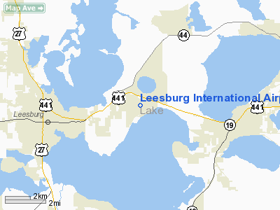
Leesburg, Florida |
| Elevation AMSL |
76 ft / 23.2 m |
| Coordinates |
28°49′23.1″N 081°48′31.4″W / 28.823083°N 81.808722°W / 28.823083; -81.808722 |
| Website |
LeesburgFlorida.gov/airport/ |
| Runways |
| Direction |
Length |
Surface |
| ft |
m |
| 13/31 |
5,000 |
1,524 |
Asphalt |
| 03/21 |
4,957 |
1,511 |
Asphalt |
| Statistics (1999) |
| Aircraft operations |
114,061 |
| Based aircraft |
186 |
| Source: Federal Aviation Administration |
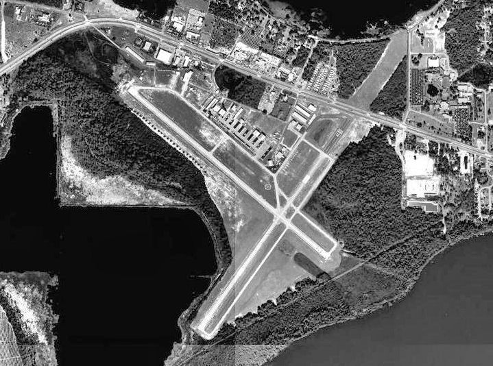
1958 aerial photo of Leesburg Airport Leesburg International Airport (IATA: LEE, ICAO: KLEE, FAA LID: LEE), formerly known as Leesburg Regional Airport, is a public airport located three miles (5 km) northeast of the central business district of Leesburg, a city in Lake County, Florida, United States. It is owned by the City of Leesburg. Facilities and aircraft
Leesburg International Airport covers an area of 769 acres (311 ha) which contains two asphalt paved runways: 3/21 measuring 4,957 x 100 ft (1,511 x 30 m) and 13/31 measuring 5,000 x 100 ft (1,524 x 30 m).
For the 12-month period ending May 18, 1999, the airport had 114,061 aircraft operations, an average of 312 per day: 99.8% general aviation and 0.2% military. There are 186 aircraft based at this airport: 67% single-engine, 23% multi-engine, 5% ultralight, 3% jet and 3% helicopter.
Passenger Service:
- There is no scheduled commercial passenger service available into Leesburg. In 2007, DayJet included Leesburg as a "Per-Seat On-Demand Destination" available through its charter service, but the company ceased operations in September 2008.
History
The airport was constructed in 1942 and was commissioned in January 1943 as Leesburg Army Airfield (AAF). It was used as a United States Army Air Forces training airfield by the Army Air Force School of Applied Tactics at Orlando Army Air Base. Leesburg was a sub-base of Alachua AAF with the 901st Army Air Force Base Unit being the host unit for the station.
The 313th Fighter Squadron was assigned to the airfield from 5 January-17 November 1943 training students with the P-40 Warhawk, with the 1158th School Squadron providing instruction in twin-engine fighter aircraft (predominately the P-38 Lightning). Leesburg was also a repair depot with several aircraft supply and ground maintenance units.
The airfield was closed after the end of World War II and the facility was turned over to the City of Leesburg.
References
The above content comes from Wikipedia and is published under free licenses – click here to read more.
Location
& QuickFacts
|
FAA Information Effective: |
2007-01-18 |
|
Airport
Identifier: |
LEE |
|
Airport
Status: |
Operational |
|
Longitude/Latitude: |
081-48-31.4000W/28-49-23.1000N
-81.808722/28.823083 (Estimated) |
|
Elevation: |
76 ft / 23.16 m (Surveyed) |
|
Land: |
769 acres |
|
From
nearest city: |
3 nautical miles NE of Leesburg, FL |
|
Location: |
Lake County, FL |
|
Magnetic Variation: |
04W (1995) |
Owner
& Manager
|
Ownership: |
Publicly owned |
|
Owner: |
City Of Leesburg |
|
Address: |
Po Box 630
Leesburg, FL 32749-0630 |
|
Phone
number: |
352-409-0404 |
|
Manager: |
Charlie Weller |
|
Address: |
501 West Meadow Street, Po Box 49630
Leesburg, FL 34779 |
|
Phone number: |
352-516-7236
ADDL PHONE 352-787-2211. |
Airport
Operations and Facilities
|
Airport Use: |
Open to public |
|
Wind
indicator: |
Yes |
|
Segmented
Circle: |
Yes |
|
Control
Tower: |
Yes |
|
Lighting
Schedule: |
DUSK-DAWN
HIRL RYS 03/21 & 13/31, PAPI RYS 03 & 21, VASI RYS
13 & 31 AND TWY LGTS OPR DUSK-2200; AFT 2200 ACTVT -
CTAF. |
|
Beacon
Color: |
Clear-Green (lighted land airport) |
|
Landing
fee charge: |
No |
|
Sectional
chart: |
Jacksonville |
|
Region: |
ASO - Southern |
|
Boundary
ARTCC: |
ZJX - Jacksonville |
|
Tie-in
FSS: |
PIE - Saint Petersburg |
|
FSS
on Airport: |
No |
|
FSS
Toll Free: |
1-800-WX-BRIEF |
|
NOTAMs
Facility: |
LEE (NOTAM-d service avaliable) |
|
Federal Agreements: |
NGPY3 |
Airport
Communications
|
CTAF: |
119.350 |
|
Unicom: |
122.725 |
Airport
Services
|
Fuel available: |
100LLA |
|
Airframe Repair: |
MAJOR |
|
Power Plant Repair: |
MAJOR |
|
Bottled
Oxygen: |
NONE |
|
Bulk
Oxygen: |
NONE |
|
Runway Information
Runway 03/21
|
Dimension: |
4957 x 100 ft / 1510.9 x 30.5 m |
|
Surface: |
ASPH, Good Condition |
|
Weight
Limit: |
Single wheel: 20000 lbs. |
|
Edge
Lights: |
High
RY 03/21 & 13/31 EDGE LGTS LCTD 9 FT EITHER SIDE OF RY EDGE. |
|
|
Runway 03 |
Runway 21 |
|
Longitude: |
081-48-42.4445W |
081-48-10.4884W |
|
Latitude: |
28-48-58.1675N |
28-49-38.3723N |
|
Elevation: |
67.00 ft |
75.00 ft |
|
Alignment: |
35 |
127 |
|
Traffic
Pattern: |
Left |
Left |
|
Markings: |
Basic, Fair Condition |
Basic, Good Condition |
|
Displaced
threshold: |
299.00 ft |
310.00 ft |
|
VASI: |
2-light PAPI on left side |
2-light PAPI on left side |
|
Obstruction: |
50 ft trees, 1200.0 ft from runway, 300 ft
right of centerline, 20:1 slope to clear
15 FT BRUSH 150 FT FROM EOR, 60 FT L OF CNTRLN. |
8 ft berm, 350.0 ft from runway, 20:1 slope
to clear |
|
Runway 13/31
|
Dimension: |
5000 x 100 ft / 1524.0 x 30.5 m |
|
Surface: |
ASPH, Good Condition |
|
Edge
Lights: |
High
RY 03/21 & 13/31 EDGE LGTS LCTD 9 FT EITHER SIDE OF RY EDGE. |
|
|
Runway 13 |
Runway 31 |
|
Longitude: |
081-48-57.9328W |
081-48-14.7538W |
|
Latitude: |
28-49-43.7772N |
28-49-12.0809N |
|
Elevation: |
74.00 ft |
68.00 ft |
|
Alignment: |
127 |
127 |
|
Traffic
Pattern: |
Left |
Left |
|
Markings: |
Non-precision instrument, Fair Condition |
Non-precision instrument, Fair Condition |
|
Crossing
Height: |
38.00 ft |
38.00 ft |
|
VASI: |
4-box on left side |
4-box on left side |
|
Visual
Glide Angle: |
3.00� |
3.00� |
|
Runway
End Identifier: |
|
Yes |
|
Radio Navigation
Aids
|
ID |
Type |
Name |
Ch |
Freq |
Var |
Dist |
|
LEE |
NDB |
Leesburg |
|
335.00 |
04W |
0.3 nm |
|
SFB |
NDB |
Sanford |
|
408.00 |
05W |
29.9 nm |
|
DED |
NDB |
Deland/dcmsnd |
|
201.00 |
05W |
31.7 nm |
|
ISM |
NDB |
Kissimmee |
|
329.00 |
05W |
37.7 nm |
|
RHZ |
NDB |
Zephyrhills |
|
253.00 |
03W |
40.3 nm |
|
EVB |
NDB |
New Smyrna Beach |
|
417.00 |
04W |
47.7 nm |
|
IAK |
NDB |
Palatka |
|
243.00 |
05W |
49.9 nm |
|
ORL |
VORTAC |
Orlando |
059X |
112.20 |
00E |
30.1 nm |
|
OCF |
VORTAC |
Ocala |
084X |
113.70 |
00E |
30.6 nm |
|
OMN |
VORTAC |
Ormond Beach |
073X |
112.60 |
00E |
46.6 nm |
|
DAB |
VOT |
Daytona Beach |
|
111.00 |
|
45.0 nm |
Remarks
- WHEN
TWR CLSD, GCO AVBL ON FREQ 121.725 THRU MCO CLNC DLVY.
- WHITE
PAINTED TIRES AROUND ALL RWY LGTS; ORANGE PAINTED TIRES AROUND ALL TWY
LGTS.
- RWY
03/21 & RWY 13/31 25' PAVED SHOULDERS EITHER SIDE.
- TREES
ALONG SOUTHWEST SIDE OF RY 13/31.
- EXISTED
PRIOR TO 1959.
Based Aircraft
|
Aircraft
based on field: |
186 |
|
Single
Engine Airplanes: |
124 |
|
Multi
Engine Airplanes: |
43 |
|
Jet Engine
Airplanes: |
5 |
|
Helicopters: |
5 |
|
Ultralights: |
9 |
Operational Statistics
Time Period: 1998-05-19
- 1999-05-18
|
Aircraft
Operations: |
313/Day |
|
General
Aviation Local: |
54.7% |
|
General
Aviation Itinerant: |
45.1% |
|
Military: |
0.2% |
Leesburg International Airport
Address:
Lake County, FL
Tel:
352-409-0404,
352-516-7236
Images
and information placed above are from
http://www.airport-data.com/airport/LEE/
We
thank them for the data!
| General
Info |
| Country |
United
States |
| State |
FLORIDA
|
| FAA ID |
LEE
|
| Latitude |
28-49-21.879N
|
| Longitude |
081-48-32.426W
|
| Elevation |
77 feet
|
| Near City |
LEESBURG
|
We don't guarantee the information is fresh and accurate. The data may
be wrong or outdated.
For more up-to-date information please refer to other sources.
|
|