|
|
Lake Wales Municipal Airport |
| Lake Wales Municipal Airport |
 |
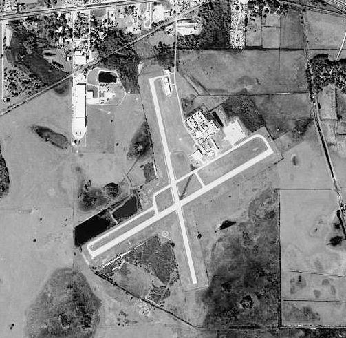
| 1999 USGS Photo |
| IATA: none – ICAO: none – FAA LID: X07 |
| Summary |
| Airport type |
Public use |
| Owner |
City of Lake Wales |
| Operator |
Mark R. Mc Duff |
| Serves |
Lake Wales, Florida |
| Location |
Lake Wales, Florida |
| Elevation AMSL |
127 ft / 39 m |
| Runways |
| Direction |
Length |
Surface |
| ft |
m |
| 06/24 |
3,999 |
1,219 |
Asphalt |
| 17/35 |
3,999 |
1,219 |
Asphalt |
| Statistics (2002) |
| Aircraft operations |
20,005 |
| Based aircraft |
17 |
| Source: Federal Aviation Administration |
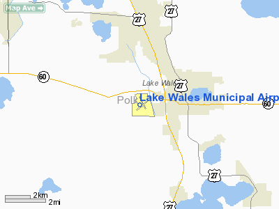
Coordinates: 27°53′37.7000″N 081°37′13.4″W / 27.893806°N 81.620389°W / 27.893806; -81.620389 Lake Wales Municipal Airport (FAA LID: X07) is a public-use airport located 2 miles (3.2 km) west of the central business district of the city of Lake Wales in Polk County, Florida, United States. The airport is publicly owned. History
During World War II, Lake Wales Army Airfield was an auxiliary airfield of Sarasota Army Airfield. III Fighter Command used the airfield for fighter training of replacement personnel.
The above content comes from Wikipedia and is published under free licenses – click here to read more.
Location
& QuickFacts
|
FAA Information Effective: |
2007-01-18 |
|
Airport
Identifier: |
X07 |
|
Airport
Status: |
Operational |
|
Longitude/Latitude: |
081-37-13.4000W/27-53-37.7000N
-81.620389/27.893806 (Estimated) |
|
Elevation: |
127 ft / 38.71 m (Surveyed) |
|
Land: |
520 acres |
|
From
nearest city: |
2 nautical miles W of Lake Wales, FL |
|
Location: |
Polk County, FL |
|
Magnetic Variation: |
02W (1985) |
Owner
& Manager
|
Ownership: |
Publicly owned |
|
Owner: |
City Of Lake Wales |
|
Address: |
Po Box 1320
Lake Wales, FL 33859-1320 |
|
Phone
number: |
863-678-4182 |
|
Manager: |
Mark R. Mc Duff |
|
Address: |
Po Box 1320
Lake Wales, FL 33859-1320 |
|
Phone number: |
863-678-4182
FBO PHONE 813-676-5918. |
Airport
Operations and Facilities
|
Airport Use: |
Open to public |
|
Wind
indicator: |
Yes |
|
Segmented
Circle: |
Yes |
|
Control
Tower: |
No |
|
Lighting
Schedule: |
DUSK-DAWN
MIRL RY 06/24 OPER DUSK-2300; AFTER 2300-KEY CTAF 7 TIMES.
FOR PAPI RY 06-KEY CTAF 3 TIMES; RY 24-KEY CTAF 5 TIMES.
RY LGTS MUST BE TURNED ON BEFORE PAPI CAN BE ACTVTD. |
|
Beacon
Color: |
Clear-Green (lighted land airport) |
|
Landing
fee charge: |
No |
|
Sectional
chart: |
Miami |
|
Region: |
ASO - Southern |
|
Boundary
ARTCC: |
ZMA - Miami |
|
Tie-in
FSS: |
PIE - Saint Petersburg |
|
FSS
on Airport: |
No |
|
FSS
Toll Free: |
1-800-WX-BRIEF |
|
NOTAMs
Facility: |
PIE (NOTAM-d service avaliable) |
|
Federal Agreements: |
NGY3 |
Airport
Communications
|
CTAF: |
122.800 |
|
Unicom: |
122.800 |
Airport
Services
|
Fuel available: |
100LLA MOGAS |
|
Airframe Repair: |
MAJOR |
|
Power Plant Repair: |
MAJOR |
|
Bottled
Oxygen: |
NONE |
|
Bulk
Oxygen: |
NONE |
|
Runway Information
Runway 06/24
|
Dimension: |
3999 x 100 ft / 1218.9 x 30.5 m |
|
Surface: |
ASPH, Fair Condition
CRACKING WITH GRASS GROWING THROUGH CRACKS. |
|
Weight
Limit: |
Single wheel: 15000 lbs. |
|
Edge
Lights: |
Medium |
|
|
Runway 06 |
Runway 24 |
|
Longitude: |
081-37-31.6720W |
081-36-53.2750W |
|
Latitude: |
27-53-25.5500N |
27-53-45.6540N |
|
Elevation: |
126.00 ft |
122.00 ft |
|
Alignment: |
59 |
127 |
|
Traffic
Pattern: |
Left |
Left |
|
Markings: |
Basic, Fair Condition |
Basic, Fair Condition |
|
Crossing
Height: |
40.00 ft |
40.00 ft |
|
VASI: |
4-light PAPI on right side |
4-light PAPI on left side |
|
Visual
Glide Angle: |
3.00� |
3.00� |
|
Obstruction: |
, 50:1 slope to clear |
42 ft trees, 1700.0 ft from runway, 35:1 slope
to clear |
|
Runway 17/35
|
Dimension: |
3999 x 75 ft / 1218.9 x 22.9 m |
|
Surface: |
ASPH, Good Condition
CRACKING WITH GRASS GROWING THROUGH CRACKS. |
|
Weight
Limit: |
Single wheel: 15000 lbs. |
|
|
Runway 17 |
Runway 35 |
|
Longitude: |
081-37-19.1920W |
081-37-09.5420W |
|
Latitude: |
27-53-59.0780N |
27-53-20.4210N |
|
Elevation: |
124.00 ft |
122.00 ft |
|
Alignment: |
127 |
127 |
|
Traffic
Pattern: |
Left |
Left |
|
Markings: |
Basic, Fair Condition |
Basic, Fair Condition |
|
Obstruction: |
10 ft trees, 300.0 ft from runway, 125 ft right
of centerline, 10:1 slope to clear
APCH SLOPE 24:1 TO EOR FROM 50 FT PLINE, 1200 FT FROM EOR. |
, 50:1 slope to clear |
|
Radio Navigation
Aids
|
ID |
Type |
Name |
Ch |
Freq |
Var |
Dist |
|
ISM |
NDB |
Kissimmee |
|
329.00 |
05W |
25.7 nm |
|
CHN |
NDB |
Wauchula |
|
261.00 |
04W |
27.0 nm |
|
PCM |
NDB |
Plant City |
|
346.00 |
02W |
29.2 nm |
|
RHZ |
NDB |
Zephyrhills |
|
253.00 |
03W |
34.8 nm |
|
TPF |
NDB |
Knight |
|
270.00 |
02W |
44.3 nm |
|
AM |
NDB |
Picny |
|
388.00 |
02W |
49.2 nm |
|
MCF |
TACAN |
Macdill |
047X |
|
04W |
47.5 nm |
|
LAL |
VORTAC |
Lakeland |
107X |
116.00 |
01E |
21.6 nm |
|
ORL |
VORTAC |
Orlando |
059X |
112.20 |
00E |
41.8 nm |
|
TPA |
VOT |
Tampa Intl |
|
111.00 |
|
48.7 nm |
Remarks
- ULTRALIGHT
ACTIVITY ON & INVOF ARPT.
- TREES
IN TRANSITIONAL SFC RY 17; APCH WEST OF RY.
- RY
17 +4 FT FENCE 205 FT FM RY END AT RY HEIGHT.
- EXISTED
PRIOR TO 1959.
Based Aircraft
|
Aircraft
based on field: |
48 |
|
Single
Engine Airplanes: |
30 |
|
Multi
Engine Airplanes: |
2 |
|
Gliders: |
11 |
|
Ultralights: |
5 |
Operational Statistics
Time Period: 2001-07-19
- 2002-07-18
|
Aircraft
Operations: |
55/Day |
|
Air Taxi: |
4.0% |
|
General
Aviation Local: |
69.9% |
|
General
Aviation Itinerant: |
25.5% |
|
Military: |
0.6% |
Lake Wales Municipal Airport
Address:
Polk County, FL
Tel:
863-678-4182
Images
and information placed above are from
http://www.airport-data.com/airport/X07/
We
thank them for the data!
| General
Info |
| Country |
United
States |
| State |
FLORIDA
|
| FAA ID |
X07
|
| Latitude |
27-53-37.700N
|
| Longitude |
081-37-13.400W
|
| Elevation |
127 feet
|
| Near City |
LAKE WALES
|
We don't guarantee the information is fresh and accurate. The data may
be wrong or outdated.
For more up-to-date information please refer to other sources.
|
|