|
|
| Keystone Heights Airport |
 |
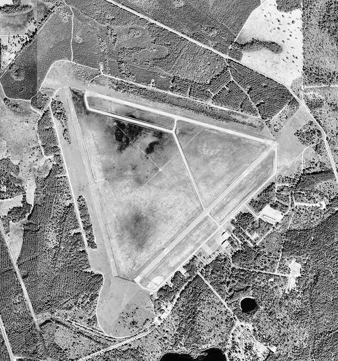
| USGS aerial photo, 5 February 1999 |
| IATA: none – ICAO: none – FAA LID: 42J |
| Summary |
| Airport type |
Public |
| Owner |
City of Keystone Heights, Florida |
| Location |
Keystone Heights, Florida |
| Elevation AMSL |
196 ft / 59.7 m |
| Coordinates |
29°50′41.1″N 082°02′51.1″W / 29.84475°N 82.047528°W / 29.84475; -82.047528 |
| Runways |
| Direction |
Length |
Surface |
| ft |
m |
| 4/22 |
5,044 |
1,537 |
Asphalt |
| 10/28 |
4,899 |
1,493 |
Asphalt |
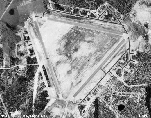 | |
Keystone Heights AAF, 1943 |
 | |
Emblem of Air University |
Keystone Heights Airport (FAA LID: 42J) is a public airport located within the city limits of Keystone Heights, Florida.
The airport is adjacent to Camp Blanding, the Florida National Guard Reservation and "Fly through History" Military Museum and Memorial Park. This museum at Camp Blanding is dedicated to the World War II units that trained there during the early 1940s.
Keystone Heights Airport employs one full-time clerk and one part-time maintenance workers. The airport is home to Express Air, a fixed wing flight training school, the European Rally and Performance Driving School;Wings of Dreams Aviation Museum and Warbird Restoration Center and 3 FAA certified airframe and power plant mechanics. The businesses located on airport property employ approximately 80 people. History
The airport was constructed in 1942 as Crystal Lake Airfield, and was commissioned in December 1942 as Keystone Army Airfield (AAF) by the United States Army Air Forces. It was used as part of the Air University Army Air Forces School of Applied Tactics (AAFSAT) tactical combat simulation school in Central and Northern Florida.
Headquartered at Orlando Army Air Base, the school's mission was to develop tactics and techniques of aerial warfare and to establish technical and tactical proficiency requirements for combat units to effectively engage and defeat enemy air forces. This was done with a wide variety of aircraft, including heavy strategic bombers; tactical fighters; medium and light bombers; reconnaissance and dive bombers, based at different airfields of the school.
It was a base for the 432d Tactical Reconnaissance Group. The 432d moved to Keystone from Alachua AAF on February 23, 1943 as the operational training unit (OTU) of the Army Air Force School of Applied Tactics. The group trained aircrews and provided reconnaissance training to assist fighter, bombardment, and ground units. Aircraft assigned were P-39 Airacobras, B-24 Liberators and P-47 Thunderbolts.
The 423d was assigned to Keystone Heights until November 1, 1943, when the aircraft and personnel of the group were assigned to the Army Air Forces Tactical Center. The 423d was then reassigned without equipment or personnel to Shaw AAF, South Carolina.
It was replaced by the 13th Fighter Squadron which flew P-40 Warhawks (17 November 1943-28 January 1944). After the end of World War II, the facility was turned over to the City of Keystone Heights in 1947.
The above content comes from Wikipedia and is published under free licenses – click here to read more.
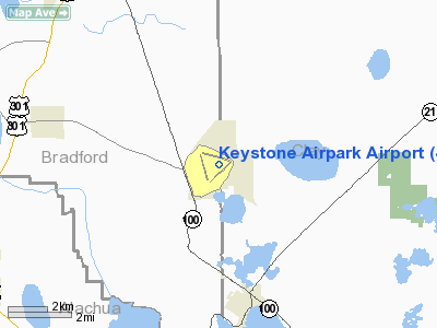
Location
& QuickFacts
|
FAA Information Effective: |
2007-01-18 |
|
Airport
Identifier: |
42J |
|
Airport
Status: |
Operational |
|
Longitude/Latitude: |
082-02-51.1000W/29-50-41.1000N
-82.047528/29.844750 (Estimated) |
|
Elevation: |
196 ft / 59.74 m (Surveyed) |
|
Land: |
2505 acres |
|
From
nearest city: |
3 nautical miles N of Keystone Heights, FL |
|
Location: |
Clay County, FL |
|
Magnetic Variation: |
03W (1985) |
Owner
& Manager
|
Ownership: |
Publicly owned |
|
Owner: |
City Of Keystone Heights |
|
Address: |
Po Box 420
Keystone Heights, FL 32656 |
|
Phone
number: |
352-473-4807 |
|
Manager: |
Keystone Airpark Authority |
|
Address: |
Po Box 420
Keystone Heights, FL 32656 |
|
Phone number: |
352-473-4807 |
Airport
Operations and Facilities
|
Airport Use: |
Open to public |
|
Wind
indicator: |
Yes |
|
Segmented
Circle: |
Yes |
|
Control
Tower: |
No |
|
Lighting
Schedule: |
DUSK-DAWN
ACTVT MIRL RY 04/22 & RY 10/28 - CTAF. |
|
Beacon
Color: |
Clear-Green (lighted land airport) |
|
Landing
fee charge: |
No |
|
Sectional
chart: |
Jacksonville |
|
Region: |
ASO - Southern |
|
Traffic
Pattern Alt: |
1000 ft |
|
Boundary
ARTCC: |
ZJX - Jacksonville |
|
Tie-in
FSS: |
GNV - Gainesville |
|
FSS
on Airport: |
No |
|
FSS
Phone: |
850-377-3291 |
|
FSS
Toll Free: |
1-800-WX-BRIEF |
|
NOTAMs
Facility: |
GNV (NOTAM-d service avaliable) |
|
Federal Agreements: |
NGPRY |
Airport
Communications
|
CTAF: |
122.700 |
|
Unicom: |
122.700 |
Airport
Services
|
Fuel available: |
100LLA |
|
Airframe Repair: |
MAJOR |
|
Power Plant Repair: |
MAJOR |
|
Bottled
Oxygen: |
NONE |
|
Bulk
Oxygen: |
NONE |
|
Runway Information
Runway 04/22
|
Dimension: |
5044 x 100 ft / 1537.4 x 30.5 m |
|
Surface: |
ASPH, Good Condition |
|
Weight
Limit: |
Single wheel: 40000 lbs.
Dual wheel: 80000 lbs. |
|
Edge
Lights: |
Medium |
|
|
Runway 04 |
Runway 22 |
|
Longitude: |
082-03-07.4250W |
082-02-26.9160W |
|
Latitude: |
29-50-11.6510N |
29-50-46.9460N |
|
Elevation: |
176.00 ft |
196.00 ft |
|
Alignment: |
45 |
127 |
|
Traffic
Pattern: |
Left |
Left |
|
Markings: |
Basic, Good Condition |
Basic, Good Condition |
|
Crossing
Height: |
40.00 ft |
40.00 ft |
|
VASI: |
2-light PAPI on left side |
2-light PAPI on left side |
|
Visual
Glide Angle: |
3.00� |
3.00� |
|
Obstruction: |
43 ft trees, 2300.0 ft from runway, 48:1 slope
to clear |
44 ft trees, 1300.0 ft from runway, 25:1 slope
to clear |
|
Runway 10/28
|
Dimension: |
4899 x 75 ft / 1493.2 x 22.9 m |
|
Surface: |
ASPH, Good Condition |
|
Weight
Limit: |
Single wheel: 30000 lbs.
Dual wheel: 60000 lbs. |
|
Edge
Lights: |
Medium |
|
|
Runway 10 |
Runway 28 |
|
Longitude: |
082-03-22.0980W |
082-02-28.3710W |
|
Latitude: |
29-50-59.4670N |
29-50-46.9010N |
|
Elevation: |
186.00 ft |
196.00 ft |
|
Alignment: |
105 |
127 |
|
Traffic
Pattern: |
Left |
Left |
|
Markings: |
Basic, Good Condition |
Basic, Good Condition |
|
Crossing
Height: |
40.00 ft |
40.00 ft |
|
VASI: |
2-light PAPI on left side |
2-light PAPI on left side |
|
Visual
Glide Angle: |
3.00� |
3.00� |
|
Obstruction: |
42 ft trees, 1660.0 ft from runway, 34:1 slope
to clear |
40 ft trees, 1200.0 ft from runway, 25:1 slope
to clear |
|
Radio Navigation
Aids
|
ID |
Type |
Name |
Ch |
Freq |
Var |
Dist |
|
GN |
NDB |
Wynds |
|
269.00 |
04W |
12.4 nm |
|
IAK |
NDB |
Palatka |
|
243.00 |
05W |
16.9 nm |
|
HEG |
NDB |
Herlong |
|
332.00 |
02W |
28.8 nm |
|
LCQ |
NDB |
Lake City |
|
204.00 |
03W |
34.4 nm |
|
JA |
NDB |
Dinns |
|
344.00 |
03W |
39.4 nm |
|
EYA |
NDB |
Eastport |
|
357.00 |
03W |
41.6 nm |
|
NZC |
TACAN |
Cecil/dcmsnd |
088X |
|
04W |
24.4 nm |
|
NIP |
TACAN |
Jacksonville |
19X |
|
04W |
30.4 nm |
|
NRB |
TACAN |
Mayport |
051X |
|
03W |
46.1 nm |
|
VQQ |
VOR |
Cecil |
|
117.90 |
03W |
23.6 nm |
|
SGJ |
VOR/DME |
St Augustine |
031X |
109.40 |
06W |
38.0 nm |
|
GNV |
VORTAC |
Gators |
109X |
116.20 |
04W |
14.9 nm |
|
CRG |
VORTAC |
Craig |
092X |
114.50 |
03W |
40.8 nm |
|
OCF |
VORTAC |
Ocala |
084X |
113.70 |
00E |
41.2 nm |
|
TAY |
VORTAC |
Taylor |
076X |
112.90 |
03W |
47.6 nm |
|
JAX |
VOT |
Jacksonville Intl |
|
111.00 |
|
43.2 nm |
Remarks
- CTN:ANIMALS
ON AND INVOF ARPT.
- RESTRICTED
AREA 2903A 1.5 MILES RY 22 END. FLY LEFT TFC TO AVOID.
- RYS
10/28 RSTRD BY AMGR TO ACFT 12500 POUNDS GWT OR LESS.
- SELF
SERVE AVGAS AVBL 24 HRS WITH CREDIT CARD. JET A BY APPOINTMENT. CALL
352-473-0031.
- EXISTED
PRIOR TO 1959.
Based Aircraft
|
Aircraft
based on field: |
77 |
|
Single
Engine Airplanes: |
31 |
|
Multi
Engine Airplanes: |
4 |
|
Jet Engine
Airplanes: |
35 |
|
Helicopters: |
4 |
|
Gliders: |
2 |
|
Ultralights: |
1 |
Operational Statistics
Time Period: 2000-09-01
- 2001-08-31
|
Aircraft
Operations: |
89/Day |
|
Air Taxi: |
1.5% |
|
General
Aviation Local: |
46.3% |
|
General
Aviation Itinerant: |
49.4% |
|
Military: |
2.8% |
Keystone Airpark Airport
Address:
Clay County, FL
Tel:
352-473-4807
Images
and information placed above are from
http://www.airport-data.com/airport/42J/
We
thank them for the data!
| General
Info |
| Country |
United
States |
| State |
FLORIDA
|
| FAA ID |
42J
|
| Latitude |
29-50-41.100N
|
| Longitude |
082-02-51.100W
|
| Elevation |
196 feet
|
| Near City |
KEYSTONE
HEIGHTS |
We don't guarantee the information is fresh and accurate. The data may
be wrong or outdated.
For more up-to-date information please refer to other sources.
|
|