 |
|
Coordinates: 28°48′22.6000″N 082°19′04.3″W / 28.806278°N 82.317861°W / 28.806278; -82.317861
| Inverness Airport |
| IATA: none – ICAO: none – FAA LID: X40 |
| Summary |
| Airport type |
Public use |
| Owner |
Citrus County |
| Operator |
Tom Davis |
| Serves |
Inverness, Florida |
| Location |
Citrus County, Florida |
| Elevation AMSL |
50 ft / 15 m |
| Runways |
| Direction |
Length |
Surface |
| ft |
m |
| 01/19 |
3,762 |
1,147 |
Asphalt |
| Statistics (2002) |
| Aircraft operations |
12,000 |
| Based aircraft |
37 |
| Source: Federal Aviation Administration |
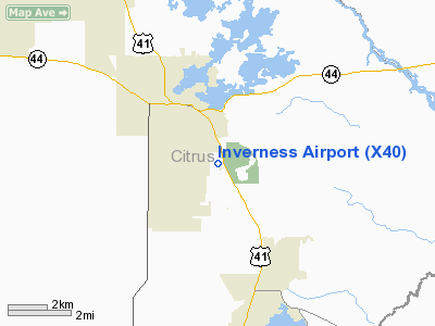
Inverness Airport (FAA LID: X40) is a public-use airport located 2 miles (3.2 km) southeast of the central business district of the city of Inverness in Citrus County, Florida, United States. The airport is publicly owned, and contains an aviation unit of the Citrus County Sheriff's Office. It is also located next to the Citrus County Speedway.
The above content comes from Wikipedia and is published under free licenses – click here to read more.
Location
& QuickFacts
|
FAA Information Effective: |
2007-01-18 |
|
Airport
Identifier: |
X40 |
|
Airport
Status: |
Operational |
|
Longitude/Latitude: |
082-18-59.3340W/28-48-30.9470N
-82.316482/28.808596 (Estimated) |
|
Elevation: |
50 ft / 15.24 m (Estimated) |
|
Land: |
120 acres |
|
From
nearest city: |
2 nautical miles SE of Inverness, FL |
|
Location: |
Citrus County, FL |
|
Magnetic Variation: |
02W (1985) |
Owner
& Manager
|
Ownership: |
Publicly owned |
|
Owner: |
Citrus County |
|
Address: |
110 N. Apopka Ave
Inverness, FL 32650 |
|
Phone
number: |
352-756-8500 |
|
Manager: |
Tom Davis
KEN FRANK, DEPT OF PUBLIC WORKS, PROJECT MGR: 352-527-5465. |
|
Address: |
P.o. Box 2050
Crystal River, FL 34423 |
|
Phone number: |
352-795-6868 |
Airport
Operations and Facilities
|
Airport Use: |
Open to public |
|
Wind
indicator: |
Yes |
|
Segmented
Circle: |
No |
|
Control
Tower: |
No |
|
Lighting
Schedule: |
DUSK-DAWN
ACTVT MIRL RY 01/19 AND REIL RYS 01 & 19 - CTAF. |
|
Beacon
Color: |
Clear-Green (lighted land airport) |
|
Landing
fee charge: |
No |
|
Sectional
chart: |
Jacksonville |
|
Region: |
ASO - Southern |
|
Boundary
ARTCC: |
ZJX - Jacksonville |
|
Tie-in
FSS: |
PIE - Saint Petersburg |
|
FSS
on Airport: |
No |
|
FSS
Toll Free: |
1-800-WX-BRIEF |
|
NOTAMs
Facility: |
PIE (NOTAM-d service avaliable) |
|
Federal Agreements: |
N1 |
Airport
Communications
|
CTAF: |
122.725 |
|
Unicom: |
122.725 |
Airport
Services
|
Fuel available: |
100LL
SELF-SERVE. |
|
Airframe Repair: |
NONE |
|
Power Plant Repair: |
NONE |
|
Bottled
Oxygen: |
NONE |
|
Bulk
Oxygen: |
NONE |
|
Runway Information
Runway 01/19
|
Dimension: |
3762 x 60 ft / 1146.7 x 18.3 m |
|
Surface: |
ASPH, Good Condition |
|
Weight
Limit: |
Single wheel: 12500 lbs. |
|
Edge
Lights: |
Medium |
|
|
Runway 01 |
Runway 19 |
|
Traffic
Pattern: |
Right |
Left |
|
Markings: |
Numbers only, Fair Condition |
Numbers only, Fair Condition |
|
VASI: |
2-light PAPI on right side |
2-light PAPI on right side |
|
Runway
End Identifier: |
Yes |
Yes |
|
Obstruction: |
13 ft trees, 465.0 ft from runway, 20:1 slope
to clear |
40 ft trees, 1000.0 ft from runway, 20:1 slope
to clear |
|
Radio Navigation
Aids
|
ID |
Type |
Name |
Ch |
Freq |
Var |
Dist |
|
LEE |
NDB |
Leesburg |
|
335.00 |
04W |
26.8 nm |
|
RHZ |
NDB |
Zephyrhills |
|
253.00 |
03W |
36.0 nm |
|
PCM |
NDB |
Plant City |
|
346.00 |
02W |
49.2 nm |
|
OCF |
VORTAC |
Ocala |
084X |
113.70 |
00E |
22.7 nm |
Remarks
- RWY
19 300' AGL TOWER 5600' N OF THR 2500' R OF CL.
- PRVDD
COORDINATION FOR THE ESTABLISHMENT OF THE PROPOSED NONFEDERAL NDB IS
COORDINATED WITH ORL/ADO AND RY EXT MAY BE SUBJ TO ENVIRONMENTAL REVIEW.
Based Aircraft
|
Aircraft
based on field: |
35 |
|
Single
Engine Airplanes: |
31 |
|
Multi
Engine Airplanes: |
2 |
|
Helicopters: |
2 |
Operational Statistics
Time Period: 2001-05-10
- 2002-05-09
|
Aircraft
Operations: |
231/Week |
|
General
Aviation Local: |
50.0% |
|
General
Aviation Itinerant: |
50.0% |
Inverness Airport
Address:
Citrus County, FL
Tel:
352-756-8500,
352-795-6868
Images
and information placed above are from
http://www.airport-data.com/airport/X40/
We
thank them for the data!
| General
Info |
| Country |
United
States |
| State |
FLORIDA
|
| FAA ID |
X40
|
| Latitude |
28-48-30.947N
|
| Longitude |
082-18-59.334W
|
| Elevation |
50 feet
|
| Near City |
INVERNESS
|
We don't guarantee the information is fresh and accurate. The data may
be wrong or outdated.
For more up-to-date information please refer to other sources.
|
|


