 |
|
|
|
|
|
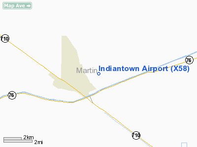
Location
& QuickFacts
|
FAA Information Effective: |
2007-01-18 |
|
Airport
Identifier: |
X58 |
|
Airport
Status: |
Operational |
|
Longitude/Latitude: |
080-26-24.1850W/27-02-11.1910N
-80.440051/27.036442 (Estimated) |
|
Elevation: |
30 ft / 9.14 m (Estimated) |
|
Land: |
600 acres |
|
From
nearest city: |
2 nautical miles NE of Indiantown, FL |
|
Location: |
Martin County, FL |
|
Magnetic Variation: |
03W (1985) |
Owner
& Manager
|
Ownership: |
Privately owned |
|
Owner: |
Indiantown Intl Inc. |
|
Address: |
Po Box 1234
Indiantown, FL 34956-1234 |
|
Phone number: |
772-597-5800 |
|
Manager: |
Clyde Dawson |
|
Address: |
Po Box 1234
Indiantown, FL 34956-1234 |
|
Phone number: |
772-597-5800 |
Airport
Operations and Facilities
|
Airport Use: |
Open to public |
|
Wind
indicator: |
Yes |
|
Segmented
Circle: |
No |
|
Control
Tower: |
No |
|
Landing
fee charge: |
Yes |
|
Sectional
chart: |
Miami |
|
Region: |
ASO - Southern |
|
Traffic
Pattern Alt: |
800 ft |
|
Boundary
ARTCC: |
ZMA - Miami |
|
Tie-in
FSS: |
MIA - Miami |
|
FSS
on Airport: |
No |
|
FSS
Phone: |
305-233-2600 |
|
FSS
Toll Free: |
1-800-WX-BRIEF |
|
NOTAMs
Facility: |
MIA (NOTAM-d service avaliable) |
Airport
Communications
|
CTAF: |
123.000 |
|
Unicom: |
123.000 |
Airport
Services
|
Fuel available: |
100LLMOGAS
FUEL AVBL WITH CREDIT CARD ONLY. |
|
Bottled
Oxygen: |
NONE |
|
Bulk
Oxygen: |
NONE |
|
Runway Information
Runway 13/31
|
Dimension: |
6300 x 75 ft / 1920.2 x 22.9 m |
|
Surface: |
TURF, Good Condition |
|
|
Runway 13 |
Runway 31 |
|
Traffic
Pattern: |
Left |
Left |
|
Displaced
threshold: |
600.00 ft |
300.00 ft |
|
Obstruction: |
4 ft fence/trees
APCH RATIO 50:1 TO DSPLCD THLD. |
15 ft road, 0.0 ft from runway
APCH RATIO 20:1 TO DSPLCD THR. |
|
Radio Navigation
Aids
|
ID |
Type |
Name |
Ch |
Freq |
Var |
Dist |
|
UTX |
NDB |
United |
|
405.00 |
03W |
9.5 nm |
|
PB |
NDB |
Rubin |
|
356.00 |
03W |
24.3 nm |
|
FPR |
NDB |
Fort Pierce |
|
275.00 |
04W |
27.3 nm |
|
VEP |
NDB |
Vero Beach |
|
392.00 |
04W |
37.7 nm |
|
PHK |
VORTAC |
Pahokee |
101X |
115.40 |
00E |
20.4 nm |
|
PBI |
VORTAC |
Palm Beach |
104X |
115.70 |
03W |
28.6 nm |
|
VRB |
VORTAC |
Vero Beach |
120X |
117.30 |
04W |
38.7 nm |
|
PBI |
VOT |
Palm Beach |
|
109.00 |
|
27.7 nm |
|
VRB |
VOT |
Vero Beach |
|
111.00 |
|
37.1 nm |
Remarks
- STANDING
WATER AT RY EDGES AFTER RAIN.
- PPR
FOR TSNT ACFT TRNG CALL 772-597-5800
- LANDING
FEE CURRENTLY IN EFFECT.
- $10
LANDING FEE WAIVED WITH FUEL PURCHASE.
- NO
TOUCH AND GO LNDGS.
- VFR
OPERNS ONLY.
Based Aircraft
|
Aircraft
based on field: |
51 |
|
Single
Engine Airplanes: |
45 |
|
Multi
Engine Airplanes: |
2 |
|
Helicopters: |
3 |
|
Gliders: |
1 |
Operational Statistics
Time Period: 2000-12-06
- 2001-12-05
|
Aircraft
Operations: |
97/Week |
|
General
Aviation Local: |
80.0% |
|
General
Aviation Itinerant: |
20.0% |
Indiantown Airport
Address:
Martin County, FL
Tel:
772-597-5800
Images
and information placed above are from
http://www.airport-data.com/airport/X58/
We
thank them for the data!
| General
Info |
| Country |
United
States |
| State |
FLORIDA
|
| FAA ID |
X58
|
| Latitude |
27-02-11.191N
|
| Longitude |
080-26-24.185W
|
| Elevation |
30 feet
|
| Near City |
INDIANTOWN
|
We don't guarantee the information is fresh and accurate. The data may
be wrong or outdated.
For more up-to-date information please refer to other sources.
|
|


