 |
|
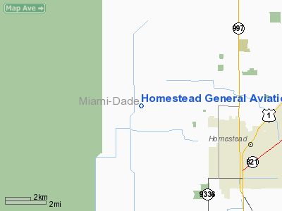
Homestead General Aviation Airport |
| Homestead General Aviation Airport |
| IATA: none – ICAO: none – FAA LID: X51 |
| Summary |
| Airport type |
Public |
| Owner |
Miami-Dade County |
| Operator |
Miami-Dade Aviation Department (MDAD) |
| Serves |
Miami, Florida |
| Location |
Miami-Dade County, Florida |
| Elevation AMSL |
7 ft / 2 m |
| Coordinates |
25°30′2″N 80°33′20″W / 25.50056°N 80.55556°W / 25.50056; -80.55556 |
| Runways |
| Direction |
Length |
Surface |
| ft |
m |
| 18/36 |
3,999 |
1,219 |
Asphalt |
| 9/27 |
2,997 |
913 |
Asphalt |
| 9U/27U |
1,000 |
305 |
Turf |
| Statistics (2002) |
| Aircraft operations |
72,084 |
| Based aircraft |
64 |
| Source: Federal Aviation Administration |
Homestead General Aviation Airport (FAA LID: X51) is a county-owned public-use airport in unincorporated Miami-Dade County, Florida, United States, located four nautical miles (7 km) northwest of the central business district of Homestead.
Facilities and aircraft
Homestead General Aviation Airport covers an area of 960 acres (388 ha) at an elevation of 7 feet (2 m) above mean sea level. It has two asphalt paved runways: 18/36 is 3,999 by 100 feet (1,219 x 30 m) and 9/27 is 2,997 by 75 feet (913 x 23 m). It also has one turf runway: 9U/27U is 1,000 by 500 feet (305 x 152 m).
For the 12-month period ending June 18, 2002, the airport had 72,084 aircraft operations, an average of 197 per day: 94% general aviation, 4% air taxi and 2% military. At that time there were 64 aircraft based at this airport: 66% single-engine, 13% multi-engine, 19% ultralight and 3% helicopter.
The above content comes from Wikipedia and is published under free licenses – click here to read more.
Location
& QuickFacts
|
FAA Information Effective: |
2007-01-18 |
|
Airport
Identifier: |
X51 |
|
Airport
Status: |
Operational |
|
Longitude/Latitude: |
080-33-15.3000W/25-29-57.2000N
-80.554250/25.499222 (Estimated) |
|
Elevation: |
7 ft / 2.13 m (Surveyed) |
|
Land: |
960 acres |
|
From
nearest city: |
4 nautical miles NW of Homestead, FL |
|
Location: |
Dade County, FL |
|
Magnetic Variation: |
03W (1985) |
Owner
& Manager
|
Ownership: |
Publicly owned |
|
Owner: |
Dade County Dept Of Aviation
GARY DELAPA - DIRECTOR. |
|
Address: |
Po Box 592075
Miami, FL 33159 |
|
Phone
number: |
305-871-7077 |
|
Manager: |
Neil V. Watson |
|
Address: |
28700 Sw 217th Ave
Homestead, FL 33030 |
|
Phone number: |
305-247-4883 |
Airport
Operations and Facilities
|
Airport Use: |
Open to public |
|
Wind
indicator: |
Yes |
|
Segmented
Circle: |
Yes |
|
Control
Tower: |
No |
|
Lighting
Schedule: |
DUSK-DAWN |
|
Beacon
Color: |
Clear-Green (lighted land airport) |
|
Landing
fee charge: |
No |
|
Sectional
chart: |
Miami |
|
Region: |
ASO - Southern |
|
Boundary
ARTCC: |
ZMA - Miami |
|
Tie-in
FSS: |
MIA - Miami |
|
FSS
on Airport: |
No |
|
FSS
Phone: |
305-233-2600 |
|
FSS
Toll Free: |
1-800-WX-BRIEF |
|
NOTAMs
Facility: |
MIA (NOTAM-d service avaliable) |
|
Federal Agreements: |
NGY |
Airport
Communications
|
CTAF: |
122.800 |
|
Unicom: |
122.800 |
Airport
Services
|
Fuel available: |
100LLA |
|
Airframe Repair: |
MAJOR |
|
Power Plant Repair: |
MAJOR |
|
Bottled
Oxygen: |
HIGH/LOW |
|
Bulk
Oxygen: |
NONE |
|
Runway Information
Runway 09/27
|
Dimension: |
2997 x 75 ft / 913.5 x 22.9 m |
|
Surface: |
ASPH, Good Condition |
|
Weight
Limit: |
Single wheel: 20000 lbs. |
|
Edge
Lights: |
Medium |
|
|
Runway 09 |
Runway 27 |
|
Longitude: |
080-33-18.3516W |
080-32-45.6445W |
|
Latitude: |
25-30-09.8352N |
25-30-09.9967N |
|
Elevation: |
6.00
ft |
7.00
ft |
|
Traffic
Pattern: |
Left |
Right |
|
Markings: |
Basic, Good Condition |
Basic, Good Condition |
|
VASI: |
2-light PAPI on left side |
2-light PAPI on left side |
|
Runway 09U/27U
|
Dimension: |
1000 x 500 ft / 304.8 x 152.4 m |
|
Surface: |
TURF, Good Condition |
|
|
Runway 09U |
Runway 27U |
|
Traffic
Pattern: |
Left |
Left |
|
Runway 18/36
|
Dimension: |
3999 x 100 ft / 1218.9 x 30.5 m |
|
Surface: |
ASPH, Good Condition |
|
Weight
Limit: |
Single wheel: 40000 lbs.
Dual wheel: 65000 lbs.
Dual
tandem wheel: 110000 lbs. |
|
Edge
Lights: |
Medium |
|
|
Runway 18 |
Runway 36 |
|
Longitude: |
080-33-25.4429W |
080-33-25.0492W |
|
Latitude: |
25-30-07.5165N |
25-29-27.9124N |
|
Elevation: |
7.00
ft |
7.00
ft |
|
Traffic
Pattern: |
Right |
Left |
|
Markings: |
Basic, Good Condition |
Basic, Good Condition |
|
VASI: |
|
4-light PAPI on right side |
|
Radio Navigation
Aids
|
ID |
Type |
Name |
Ch |
Freq |
Var |
Dist |
|
PJN |
NDB |
Plantation |
|
242.00 |
03W |
42.2 nm |
|
FX |
NDB |
Praiz |
|
221.00 |
02W |
43.5 nm |
|
HST |
TACAN |
Homestead |
019X |
|
03W |
9.5 nm |
|
VKZ |
VOR/DME |
Virginia Key |
118X |
117.10 |
04W |
26.5 nm |
|
FLL |
VOR/DME |
Fort Lauderdale |
091X |
114.40 |
00E |
40.9 nm |
|
DHP |
VORTAC |
Dolphin |
086X |
113.90 |
04W |
21.2 nm |
|
MIA |
VOT |
Miami Intl |
|
112.00 |
|
23.2 nm |
Remarks
- PARACHUTE
JUMPING IN AREA.
- EXTENSIVE
CROP DUSTING IN AREA.
- ULTRALIGHT
ACTIVITY ON & INVOF OF ARPT.
- AEROBATIC
BOX SOUTH OF ARPT.
- USE
OF ULTRALIGHT OPNS AREA IS LMTD TO ULTRALIGHTS & STOL TYPE ACFT
THAT HAVE AN APCH SPEED OF 50 KTS OR LESS; CTC AMGR ON 305-247-4883
PRIOR TO USE.
- VFR
ONLY.
Based Aircraft
|
Aircraft
based on field: |
64 |
|
Single
Engine Airplanes: |
42 |
|
Multi
Engine Airplanes: |
8 |
|
Helicopters: |
2 |
|
Ultralights: |
12
ULTRALIGHT 2500. |
Operational Statistics
Time Period: 2001-06-19
- 2002-06-18
|
Aircraft
Operations: |
198/Day |
|
Air Taxi: |
3.6% |
|
General
Aviation Local: |
30.5% |
|
General
Aviation Itinerant: |
63.8% |
|
Military: |
2.1% |
Homestead General Aviation Airport
Address:
Dade County, FL
Tel:
305-871-7077,
305-247-4883
Images
and information placed above are from
http://www.airport-data.com/airport/X51/
We
thank them for the data!
| General
Info |
| Country |
United
States |
| State |
FLORIDA
|
| FAA ID |
X51
|
| Latitude |
25-29-55.397N
|
| Longitude |
080-33-15.211W
|
| Elevation |
9 feet
|
| Near City |
HOMESTEAD
|
We don't guarantee the information is fresh and accurate. The data may
be wrong or outdated.
For more up-to-date information please refer to other sources.
|
|


