 |
|
Coordinates: 29°16′49″N 082°07′29″W / 29.28028°N 82.12472°W / 29.28028; -82.12472
| Greystone Airport |
| IATA: none – ICAO: none – FAA LID: 17FL |
| Summary |
| Airport type |
Private |
| Owner |
Jumbolair Inc. |
| Operator |
James Garemore |
| Serves |
Ocala, Florida |
| Location |
Anthony, Florida |
| Elevation AMSL |
100 ft / 30 m |
| Website |
www.jumbolair.com |
| Runways |
| Direction |
Length |
Surface |
| ft |
m |
| 18/36 |
7,550 |
2,301 |
Asphalt |
| 9/27 |
3,640 |
1,109 |
Turf |
| Source: Federal Aviation Administration |
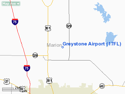
Greystone Airport (FAA LID: 17FL) is a private-use airport. It is located in the unincorporated community of Anthony, which is seven miles (11 km) northeast of Ocala, Florida, USA. Jumbolair, Inc. owns and operates Greystone. The airport has two runways: 18/36 with an asphalt pavement measuring 7,550 x 210 ft (2,301 x 64 m) and 9/27 with a grass surface measuring 3,640 x 100 ft (1,109 x 30 m). According to FAA documents, 18/36 was once so degraded that only the smallest aircraft could use it. The main runway has recently been repaved to fix the damage.
Jumbolair
Jumbolair Aviation Estates is an aviation-related gated community and airpark situated alongside the airport's runway. Terri Jones, a former Revlon model and flying enthusiast, manages the estates. A 380 acres (150 ha) horse ranch formerly built by Muriel Vanderbilt and purchased by Jones' first husband Arthur Jones in 1980 sits at the community's center. The 550 acres (220 ha) development contains two 3 acres (1.2 ha) lots connected by taxiways which lead to the runways.
John Travolta and his wife Kelly Preston were some of the first land purchasers. The runway length allows Travolta, a pilot, to operate his Boeing 707 jet. In January 2007, litigation prevented all property owners in the subdivision from accessing the runway with their aircraft. The access issue was resolved when Jumbolair purchased the adjacent land and remaining airport rights. In January 2008 five teens died after the 2008 BMW M5 they were driving flew off an 85-foot (26 m) embankment into a tree at the end of runway.
The above content comes from Wikipedia and is published under free licenses – click here to read more.
Location
& QuickFacts
|
FAA Information Effective: |
2007-01-18 |
|
Airport
Identifier: |
17FL |
|
Airport
Status: |
Operational |
|
Longitude/Latitude: |
082-07-29.3330W/29-16-48.9080N
-82.124815/29.280252 (Estimated) |
|
Elevation: |
100 ft / 30.48 m (Estimated) |
|
Land: |
0 acres |
|
From
nearest city: |
7 nautical miles NE of Ocala, FL |
|
Location: |
Marion County, FL |
|
Magnetic Variation: |
03W (1985) |
Owner
& Manager
|
Ownership: |
Privately owned |
|
Owner: |
James & Christine Garemore |
|
Address: |
8851 W. Anthony Road
Ocala, FL 34479 |
|
Phone
number: |
352-629-0800 |
|
Manager: |
James Garemore |
|
Address: |
8851 W. Anthony Road
Ocala, FL 34479 |
|
Phone number: |
352-629-0800 |
Airport
Operations and Facilities
|
Airport Use: |
Private |
|
Wind
indicator: |
Yes |
|
Segmented
Circle: |
No |
|
Control
Tower: |
No |
|
Lighting
Schedule: |
RDO-CTL
ACTVT MIRL RY 18/36 - 122.7 |
|
Landing
fee charge: |
No |
|
Sectional
chart: |
Jacksonville |
|
Region: |
ASO - Southern |
|
Boundary
ARTCC: |
ZJX - Jacksonville |
|
Tie-in
FSS: |
GNV - Gainesville |
|
FSS
on Airport: |
No |
|
FSS
Phone: |
850-377-3291 |
|
FSS
Toll Free: |
1-800-WX-BRIEF |
|
Runway Information
Runway 09/27
|
Dimension: |
3640 x 100 ft / 1109.5 x 30.5 m |
|
Surface: |
TURF,
FIRST 1800 FT OF RY 18 DETERIORATING WITH POT HOLES AND SEVERE CRACKING.
ASPHALT SURFACE IS ONLY 2 INCHES THICK. PAVEMENT STRUCTURE CAN ONLY
SUPPORT LIGHT LOAD SINGLE WHEEL ACFT. HEAVIER ACFT MAY CAUSE IMMEDIATE
STRUCTUAL DAMAGE TO THE DETERIORATED SURFACE AND MAY GENERATE FOD. |
|
|
Runway 09 |
Runway 27 |
|
Traffic
Pattern: |
Left |
Left |
|
Runway 18/36
|
Dimension: |
7550 x 210 ft / 2301.2 x 64.0 m |
|
Surface: |
ASPH, Poor Condition
FIRST 1800 FT OF RY 18 DETERIORATING WITH POT HOLES AND SEVERE CRACKING.
ASPHALT SURFACE IS ONLY 2 INCHES THICK. PAVEMENT STRUCTURE CAN ONLY
SUPPORT LIGHT LOAD SINGLE WHEEL ACFT. HEAVIER ACFT MAY CAUSE IMMEDIATE
STRUCTUAL DAMAGE TO THE DETERIORATED SURFACE AND MAY GENERATE FOD. |
|
Edge
Lights: |
Medium |
|
|
Runway 18 |
Runway 36 |
|
Traffic
Pattern: |
Left |
Left |
|
Markings: |
Basic, |
Basic, |
|
Displaced
threshold: |
1800.00 ft |
1945.00 ft |
|
VASI: |
|
2-box on left side |
|
Obstruction: |
12 ft trees |
18 ft fence |
|
Radio Navigation
Aids
|
ID |
Type |
Name |
Ch |
Freq |
Var |
Dist |
|
GN |
NDB |
Wynds |
|
269.00 |
04W |
23.6 nm |
|
IAK |
NDB |
Palatka |
|
243.00 |
05W |
27.7 nm |
|
LEE |
NDB |
Leesburg |
|
335.00 |
04W |
32.4 nm |
|
DED |
NDB |
Deland/dcmsnd |
|
201.00 |
05W |
46.4 nm |
|
OCF |
VORTAC |
Ocala |
084X |
113.70 |
00E |
8.2 nm |
|
GNV |
VORTAC |
Gators |
109X |
116.20 |
04W |
25.9 nm |
Remarks
- 1500
FT TOWER 3 MILES EAST AND 600 FT TOWER 1.5 MILES SOUTH.
- VFR
OPNS AND PVT USE ONLY.
Based Aircraft
|
Aircraft
based on field: |
22 |
|
Single
Engine Airplanes: |
17 |
|
Multi
Engine Airplanes: |
5 |
Greystone Airport
Address:
Marion County, FL
Tel:
352-629-0800
Images
and information placed above are from
http://www.airport-data.com/airport/17FL/
We
thank them for the data!
| General
Info |
| Country |
United
States |
| State |
FLORIDA
|
| FAA ID |
17FL
|
| Latitude |
29-16-48.908N
|
| Longitude |
082-07-29.333W
|
| Elevation |
100 feet
|
| Near City |
OCALA
|
We don't guarantee the information is fresh and accurate. The data may
be wrong or outdated.
For more up-to-date information please refer to other sources.
|
|


