 |
|
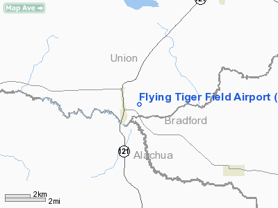
Flying Tiger Field Airport |
|
|
Location
& QuickFacts
|
FAA Information Effective: |
2007-01-18 |
|
Airport
Identifier: |
FL54 |
|
Airport
Status: |
Operational |
|
Longitude/Latitude: |
082-24-38.4000W/29-56-07.8600N
-82.410667/29.935517 (Estimated) |
|
Elevation: |
115 ft / 35.05 m (Estimated) |
|
Land: |
13 acres |
|
From
nearest city: |
1 nautical miles E of Worthington, FL |
|
Location: |
Union County, FL |
|
Magnetic Variation: |
04W (2000) |
Owner
& Manager
|
Ownership: |
Privately owned |
|
Owner: |
Les-que One Inc. |
|
Address: |
Po Box 188
Worthington Springs, FL 32697 |
|
Phone
number: |
386-594-2777 |
|
Manager: |
John D. Rimes Jr. |
|
Address: |
Po Box 188
Worthington Springs, FL 32697 |
|
Phone number: |
386-594-2777 |
Airport
Operations and Facilities
|
Airport Use: |
Private |
|
Wind
indicator: |
Yes |
|
Segmented
Circle: |
Yes |
|
Control
Tower: |
No |
|
Lighting
Schedule: |
DUSK-DAWN |
|
Beacon
Color: |
Clear-Green (lighted land airport) |
|
Sectional chart: |
Jacksonville |
|
Region: |
ASO - Southern |
|
Boundary ARTCC: |
ZJX - Jacksonville |
|
Tie-in FSS: |
GNV - Gainesville |
|
FSS Phone: |
850-377-3291 |
|
FSS Toll Free: |
1-800-WX-BRIEF |
Airport
Services
|
Runway Information
Runway 09/27
|
Dimension: |
2900 x 200 ft / 883.9 x 61.0 m |
|
Surface: |
TURF, |
|
|
Runway 09 |
Runway 27 |
|
Traffic
Pattern: |
Left |
Left |
|
Runway 18/36
|
Dimension: |
4000 x 175 ft / 1219.2 x 53.3 m |
|
Surface: |
TURF, |
|
Edge
Lights: |
Non-standard lighting system
RY 18/36 EDGES & THLDS MKD AND LGTD WITH WHITE PLASTIC HALF
BARRELS WITH LGTS MOUNTED ON TOP. |
|
|
Runway 18 |
Runway 36 |
|
Traffic
Pattern: |
Left |
Left |
|
Displaced
threshold: |
700.00 ft
RY 18/36 DSPLCD THLDS MKD & LGTD WITH 3 WHITE PLASTIC
HALF BARRELS WITH LGTS MOUNTED ON TOP ON EACH SIDE OF RY. |
300.00 ft |
|
Obstruction: |
35 ft trees, 150.0 ft from runway |
20 ft trees, 225.0 ft from runway |
|
Radio Navigation
Aids
|
ID |
Type |
Name |
Ch |
Freq |
Var |
Dist |
|
LCQ |
NDB |
Lake City |
|
204.00 |
03W |
17.4 nm |
|
GN |
NDB |
Wynds |
|
269.00 |
04W |
20.2 nm |
|
IAK |
NDB |
Palatka |
|
243.00 |
05W |
35.6 nm |
|
HEG |
NDB |
Herlong |
|
332.00 |
02W |
37.4 nm |
|
JA |
NDB |
Dinns |
|
344.00 |
03W |
44.9 nm |
|
NZC |
TACAN |
Cecil/dcmsnd |
088X |
|
04W |
32.9 nm |
|
NIP |
TACAN |
Jacksonville |
19X |
|
04W |
42.3 nm |
|
VQQ |
VOR |
Cecil |
|
117.90 |
03W |
31.8 nm |
|
GNV |
VORTAC |
Gators |
109X |
116.20 |
04W |
16.3 nm |
|
TAY |
VORTAC |
Taylor |
076X |
112.90 |
03W |
35.0 nm |
|
CTY |
VORTAC |
Cross City |
057X |
112.00 |
02W |
39.0 nm |
|
OCF |
VORTAC |
Ocala |
084X |
113.70 |
00E |
46.6 nm |
Remarks
- PRVDD
VFR OPNS & PVT USE.
Based Aircraft
|
Aircraft
based on field: |
7 |
|
Single
Engine Airplanes: |
3 |
|
Multi
Engine Airplanes: |
1 |
|
Ultralights: |
3 |
Flying Tiger Field Airport
Address:
Union County, FL
Tel:
386-594-2777
Images
and information placed above are from
http://www.airport-data.com/airport/FL54/
We
thank them for the data!
| General
Info |
| Country |
United
States |
| State |
FLORIDA
|
| FAA ID |
FL54
|
| Latitude |
29-56-07.860N
|
| Longitude |
082-24-38.400W
|
| Elevation |
85 feet
|
| Near City |
WORTHINGTON
|
We don't guarantee the information is fresh and accurate. The data may
be wrong or outdated.
For more up-to-date information please refer to other sources.
|
|


