 |
|
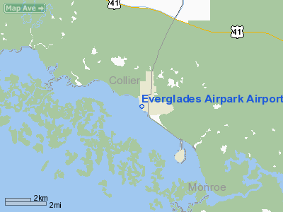
Everglades Airpark Airport |
Coordinates: 25°50′55.9000″N 081°23′25.0″W / 25.848861°N 81.39028°W / 25.848861; -81.39028
| Everglades Airpark |
| IATA: none – ICAO: none – FAA LID: X01 |
| Summary |
| Airport type |
Public use |
| Owner |
Collier County Arpt Auth |
| Operator |
Robert Tweedie |
| Serves |
Everglades, Florida |
| Location |
Collier County, Florida |
| Elevation AMSL |
5 ft / 2 m |
| Runways |
| Direction |
Length |
Surface |
| ft |
m |
| 15/33 |
2,400 |
732 |
Asphalt |
| Statistics (1999) |
| Aircraft operations |
4,800 |
| Based aircraft |
7 |
| Source: Federal Aviation Administration |
Everglades Airpark (FAA LID: X01) is a public-use airport located 1 mile (1.6 km) southwest of the central business district of the city of Everglades in Collier County, Florida, United States. The airport is publicly owned.
The above content comes from Wikipedia and is published under free licenses – click here to read more.
Location
& QuickFacts
|
FAA Information Effective: |
2007-01-18 |
|
Airport
Identifier: |
X01 |
|
Airport
Status: |
Operational |
|
Longitude/Latitude: |
081-23-24.2860W/25-50-55.3620N
-81.390079/25.848712 (Estimated) |
|
Elevation: |
5 ft / 1.52 m (Surveyed) |
|
Land: |
29 acres |
|
From
nearest city: |
1 nautical miles SW of Everglades, FL |
|
Location: |
Collier County, FL |
|
Magnetic Variation: |
02W (1985) |
Owner
& Manager
|
Ownership: |
Publicly owned |
|
Owner: |
Collier County Arpt Auth |
|
Address: |
2003 Mainsail Drive
Naples, FL 34114 |
|
Phone number: |
941-642-7878 |
|
Manager: |
Robert Tweedie |
|
Address: |
2003 Mainsail Dr
Naples, FL 34114 |
|
Phone number: |
239-695-2778 |
Airport
Operations and Facilities
|
Airport Use: |
Open to public |
|
Wind
indicator: |
Yes |
|
Segmented
Circle: |
Yes |
|
Control
Tower: |
No |
|
Lighting
Schedule: |
DUSK-DAWN |
|
Beacon
Color: |
Clear-Green (lighted land airport) |
|
Landing
fee charge: |
No |
|
Sectional
chart: |
Miami |
|
Region: |
ASO - Southern |
|
Boundary
ARTCC: |
ZMA - Miami |
|
Tie-in
FSS: |
MIA - Miami |
|
FSS
on Airport: |
No |
|
FSS
Phone: |
305-233-2600 |
|
FSS
Toll Free: |
1-800-WX-BRIEF |
|
NOTAMs
Facility: |
MIA (NOTAM-d service avaliable) |
|
Federal Agreements: |
NGY |
Airport
Communications
Airport
Services
|
Fuel available: |
100LL
FUEL AVBL 24 HRS WITH CREDIT CARD. |
|
Airframe Repair: |
NONE |
|
Power Plant Repair: |
NONE |
|
Bottled
Oxygen: |
NONE |
|
Bulk
Oxygen: |
NONE |
|
Runway Information
Runway 15/33
|
Dimension: |
2400 x 50 ft / 731.5 x 15.2 m |
|
Surface: |
ASPH, Good Condition |
|
Weight
Limit: |
Single wheel: 20000 lbs. |
|
Edge
Lights: |
Medium |
|
|
Runway 15 |
Runway 33 |
|
Traffic
Pattern: |
Right |
Left |
|
Markings: |
Basic, Fair Condition |
Basic, Fair Condition |
|
Obstruction: |
50 ft trees, 1200.0 ft from runway, 200 ft
left of centerline, 20:1 slope to clear
4 FT BRUSH 10 FT FROM EOR. |
24 ft trees, 750.0 ft from runway, 125 ft right
of centerline, 22:1 slope to clear
3 FT BRUSH 15 FT FROM EOR. |
|
Radio Navigation
Aids
|
ID |
Type |
Name |
Ch |
Freq |
Var |
Dist |
|
APF |
NDB |
Naples |
|
201.00 |
03W |
27.8 nm |
|
CYY |
VOR/DME |
Cypress |
023X |
108.60 |
03W |
27.8 nm |
|
RSW |
VORTAC |
Lee County |
055X |
111.80 |
02W |
45.9 nm |
Remarks
- HIGH
DENSITY BIRD POPULATION ON & AROUND ARPT.
- 10
FT TREES 50 -150 FT W OF RWY.
- CTC
AMGR AT (941) 695-2778 FOR RON FEES.
- PAEW
INVOF RY 15/33 INDEFLY.
- RY
15 SAFETY AREA ENDS AT END OF RY.
- RY
33 SAFETY AREA ENDS AT END OF RY; DITCH 54 FT L OF CNTRLN FIRST 664
FT OF RY 33.
- VFR
ONLY.
Based Aircraft
|
Aircraft
based on field: |
8 |
|
Single
Engine Airplanes: |
7 |
|
Multi
Engine Airplanes: |
1 |
Operational Statistics
Time Period: 1998-08-26
- 1999-08-25
|
Aircraft
Operations: |
93/Week |
|
General
Aviation Local: |
40.0% |
|
General
Aviation Itinerant: |
60.0% |
Everglades Airpark Airport
Address:
Collier County, FL
Tel:
941-642-7878, 239-695-2778
Images
and information placed above are from
http://www.airport-data.com/airport/X01/
We
thank them for the data!
| General
Info |
| Country |
United
States |
| State |
FLORIDA
|
| FAA ID |
X01
|
| Latitude |
25-50-55.362N
|
| Longitude |
081-23-24.286W
|
| Elevation |
5 feet
|
| Near City |
EVERGLADES
|
We don't guarantee the information is fresh and accurate. The data may
be wrong or outdated.
For more up-to-date information please refer to other sources.
|
|


