|
 |
|
||||
|
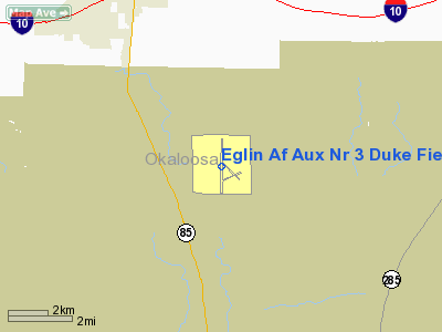
Duke Field (IATA: EGI, ICAO: KEGI, FAA LID: EGI), also known as Eglin AFB Auxiliary Field #3, is a military airport located three miles (5 km) south of the central business district of Crestview, in Okaloosa County, Florida, United States. Duke FieldThe installation is named for 1st Lt Robert L. Duke, who died in the crash of Curtiss A-25A-20-CS Shrike, 42-79823, near Spencer, Tennessee on 29 December 1943. He was assigned as Assistant A-3 to the Proving Ground of the Army Air Forces Proving Ground Command at Eglin Field, now Eglin Air Force Base. The Duke Field installation is about 12 miles (19 km) north of the Eglin AFB East Gate on Florida State Road 85. Duke Field has two asphalt paved runways: Runway 18/36, measuring 8,000 x 150 ft (2,438 x 46 m) and Assault Runway 180/360, measuring 3,500 x 60 ft (1,067 x 18 m). Although technically an auxiliary field to Eglin AFB, Duke Field is essentially a self-contained installation. The airfield has its own air traffic control tower, aircraft rescue and fire fighting (ARFF) facilities, instrument landing system (ILS), TACAN and support infrastructure such as a large flight line/ramp area, hangars, maintenance facilities and other operational and administrative support buildings. Current operations
Today, Duke Field is essentially a small air base in its own right. Primarily an Air Force Reserve Command (AFRC) installation, the Duke Field facility is hosted by the 919th Special Operations Wing (919 SOW), operating the MC-130E Combat Talon I aircraft. As an AFRC unit, the 919 SOW is operationally gained by the Air Force Special Operations Command (AFSOC), headquartered at nearby Hurlburt Field. The 919 SOW previously operated the AC-130A Spectre gunship aircraft prior to transitioning to the MC-130E. HistoryDuke Field was one of the first auxiliary fields built on the Eglin Field / Eglin AFB complex. Clearing and grading began 23 January 1941 , with the first building foundations laid on 15 February 1942. Field 3 was used as a training base by the Doolittle Raiders in 1942. Shortly after the end of World War II, the field was one of several sites used in the production of the 1949 feature film Twelve O'Clock High. In the 1950s, Duke Field became home to the 3205th Drone Group, which operated radio remote-controlled B-17s and F-80s that were used for gunnery practice over the Gulf of Mexico. They were also used in the nuclear test program by flying the unmanned aircraft through atomic clouds to gather fallout information. A large hump-backed steel hangar, the "Butler Hangar", 160 feet (49 m) X 130 feet, transported from Trinidad (probably from the former Waller Air Force Base, closed 28 May 1949 due to budget cuts), was erected at Auxiliary Field 3 between 1 April and ~10 July 1950, by personnel of Company 'C', 806th Aviation Engineering Battalion, under Capt. Samuel M. Cable, and the men of the 550th Guided Missiles Wing. Project Officer was Capt. Clarence A. Ebbert of the Proving Ground Command Installations Division. An additional four feet of roof clearance was added to accommodate B-17s in the 21,000-square-foot (2,000 m) structure. Concrete block buildings, 160 feet (49 m) X 40 feet, were erected on the flanks of the hangar. Concurrently, the 8,000-foot (2,400 m) runway was widened to 100 feet (30 m) and additional parking ramps were constructed, with 117,327 cubic yards of dirt excavated. The new ramps and runway expansion consisted of asphalt over a crushed shell base. In 1960 and 1961, in preparation for the Bay of Pigs Invasion, Duke Field was host to 'sanitized' Douglas C-54s and Curtiss C-46s used for transporting personnel, armaments and supplies between US bases such as Homestead AFB and Opa-Locka Airport and CIA-run bases in Guatemala and latterly Nicaragua. A unit at the field was responsible for 'sanitizing' and adapting about 20 Douglas B-26 Invaders for use by Cuban exile aircrews during the invasion. A few Lockheed T-33s and C-130s were also prepared for use in the conflict, but not used. Between August and October 1970, during the Vietnam War, the Joint Contingency Task Group used AFROTC facilities at Duke Field to house US Army Special Forces troops involved in Operation Ivory Coast, a mission to rescue prisoners of war at Son Tay, North Vietnam. Aircraft based at Eglin AFB and Hurlburt Field involved in the training also used Duke Field daily as an operational airstrip to maintain a low profile. In 1980, Duke Field was also one of the fields used in training for Operation Credible Sport, an initiative to prepare for a second rescue attempt of American hostages held in Iran using C-130 aircraft modified with multiple rocket engines for extremely short landings and takeoffs. Most of the testing for this was done at Wagner Field, Aux. Fld. 1, and it was there during a 29 October 1980 demonstration of one of the highly modified YMC-130H Credible Sport aircraft that a malfunction and hard landing resulted in the destruction of this particular aircraft. All crew aboard the aircraft survived. 2008 Doolittle reunionSix original Raiders were present at Duke Field, on Saturday 31 May 2008 for the culmination of their annual reunion. Three civilian B-25s in warbird markings reenacted the training take-off sessions, with personnel from NAS Pensacola as flight deck crew representing that service's contribution to the Tokyo raid. The above content comes from Wikipedia and is published under free licenses – click here to read more.
Runway InformationRunway 18/36
Runway 180/360
Radio Navigation Aids
Remarks
Operational Statistics
Eglin Air Force Aux Nr 3 Duke Field Airport Address: Marion County, FL Tel: 904-882-2013 Images
and information placed above are from We thank them for the data!
We don't guarantee the information is fresh and accurate. The data may
be wrong or outdated.
|
|||||||||||||||||||||||||||||||||||||||||||||||||||||||||||||||||||||||||||||||||||||||||||||||||||||||||||||||||||||||||||||||||||||||||||||||||||||||||||||||||||||||||||||||||||||||||||||||||||||||||||||||||||||||||||||||||||||||||||||||||||||||||||||||||||||||||||||||||||||||||||||||||||||||||||||||||||||||||||||||||||||||||||||||||||||||||

 |
|
Copyright 2004-2024 © by Airports-Worldwide.com, Vyshenskoho st. 36, Lviv 79010, Ukraine Legal Disclaimer |