|
|
Deland Municipal - Sidney H Taylor Field Airport |
Coordinates: 29°04′01″N 081°17′02″W / 29.06694°N 81.28389°W / 29.06694; -81.28389
DeLand Municipal Airport
Sidney H. Taylor Field |
 |
| IATA: none – ICAO: KDED – FAA LID: DED |
| Summary |
| Airport type |
Public |
| Owner |
City of DeLand |
| Serves |
DeLand, Florida |
| Elevation AMSL |
79 ft / 24 m |
| Website |
www.deland.org/airport/ |
| Runways |
| Direction |
Length |
Surface |
| ft |
m |
| 12/30 |
6,000 |
1,829 |
Asphalt |
| 5/23 |
4,300 |
1,311 |
Asphalt |
| Statistics (2002) |
| Aircraft operations |
77,710 |
| Based aircraft |
162 |
| Source: Federal Aviation Administration |
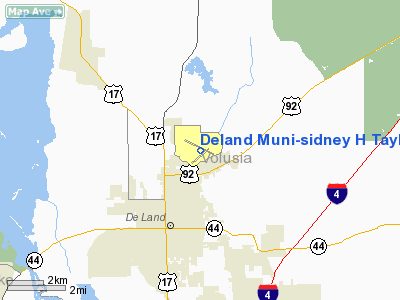
DeLand Municipal Airport (ICAO: KDED, FAA LID: DED), also known as Sidney H. Taylor Field, is a city-owned public-use airport located three miles (5 km) northeast of the central business district of DeLand, a city in Volusia County, Florida, United States.
Although most U.S. airports use the same three-letter location identifier for the FAA and IATA, DeLand Municipal Airport is assigned DED by the FAA but has no designation from the IATA (which assigned DED to Jolly Grant Airport in Dehradun, India). Facilities and aircraft
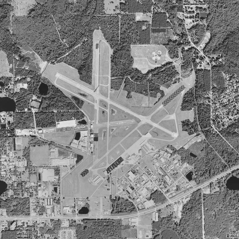
DeLand Municipal Airport covers an area of 1,289 acres (522 ha) which contains two asphalt paved runways: 12/30 measuring 6,000 x 100 ft (1,829 x 30 m) and 5/23: 4,300 x 75 ft (1,311 x 23 m).
For the 12-month period ending May 7, 2002, the airport had 77,710 aircraft operations, an average of 212 per day: 99% general aviation, 1% air taxi and <1% military. There are 162 aircraft based at this airport: 70% single-engine, 23% multi-engine, 2% jet, 4% helicopter and 1% ultralight.
History
Military useThe city first began developing the airport in the 1920s with the first asphalt runway laid around 1936. In 1942, the City of DeLand donated the facility to the U.S. Navy and it was renamed DeLand Naval Air Station on 17 November 1942.
 | |
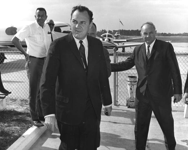
Governor Claude Kirk visited DeLand Airport in March, 1967 |
Following extensive military construction, NAS DeLand's primary focus was advanced training for Navy flight crews in land-based PBO Ventura and PB4Y-2 Privateer patrol bombers, and carrier-based SBD Dauntless dive bombers. Several of the U.S. Navy's present day maritime patrol and reconnaissance (VP) squadrons operating the P-3 Orion trace their squadron lineage to being initially established at NAS Deland during World War II.
In 1944, training in the carrier-based F6F Hellcat fighter was also added to NAS DeLand's mission.
As many as 331 officers and 1,140 enlisted men were stationed at NAS DeLand by early 1944. NAS DeLand also maintained an outlying field at Spruce Creek (OLF Spruce Creek) for use in carrier landing training, and boat facilities were maintained on Crescent Lake and at DeLeon Springs for use in rescuing downed pilots. Generally, pilots in trouble would rather crash land on water than land. Nine Mile Point on Lake George was also under NAS Deland's control and was used as a practice bombing site with a Navy PBY Catalina seaplane stationed nearby in the event of an aircraft mishap on the lake. This Lake George site is still used today as part of the Navy's Pinecastle Electronic Warfare and Bombing Range managed by NAS Jacksonville.
NAS DeLand was decommissioned following the end of World War II, its control tower closed, and control of the airfield returned to the City of DeLand. Numerous former military buildings remain standing as part of the airport's industrial park and the Naval Air Station DeLand Museum.
Current use
Today, the airport serves as an uncontrolled general aviation reliever airport to commercial operations at Daytona Beach International Airport (DAB), Orlando Sanford International Airport (SFB) and Orlando International Airport (MCO). In 2007, an analysis was completed for the possible establishment of an FAA Level 1 air traffic control tower at DED under the FAA's Contract Tower Program.
The above content comes from Wikipedia and is published under free licenses – click here to read more.
Location
& QuickFacts
|
FAA Information Effective: |
2007-01-18 |
|
Airport
Identifier: |
DED |
|
Airport
Status: |
Operational |
|
Longitude/Latitude: |
081-17-01.5000W/29-04-01.3000N
-81.283750/29.067028 (Estimated) |
|
Elevation: |
79 ft / 24.08 m (Surveyed) |
|
Land: |
1289 acres |
|
From
nearest city: |
3 nautical miles NE of Deland, FL |
|
Location: |
Volusia County, FL |
|
Magnetic Variation: |
05W (2000) |
Owner
& Manager
|
Ownership: |
Publicly owned |
|
Owner: |
City Of Deland |
|
Address: |
336 W Michigan Ave
Deland, FL 32721 |
|
Phone number: |
386-740-6955 |
|
Manager: |
Nickolis Landgraff |
|
Address: |
1777 Langley Avenue
Deland, FL 32724 |
|
Phone number: |
386-740-6955 |
Airport
Operations and Facilities
|
Airport Use: |
Open to public |
|
Wind
indicator: |
Yes |
|
Segmented
Circle: |
Yes |
|
Control
Tower: |
No |
|
Lighting
Schedule: |
DUSK-DAWN
ACTVT MIRL RYS 05/23 & 12/30 - CTAF. PAPI LGTS OPR CONT
ALL RYS. |
|
Beacon
Color: |
Clear-Green (lighted land airport) |
|
Landing
fee charge: |
No |
|
Sectional
chart: |
Jacksonville |
|
Region: |
ASO - Southern |
|
Boundary
ARTCC: |
ZJX - Jacksonville |
|
Tie-in
FSS: |
PIE - Saint Petersburg |
|
FSS
on Airport: |
No |
|
FSS
Toll Free: |
1-800-WX-BRIEF |
|
NOTAMs
Facility: |
PIE (NOTAM-d service avaliable) |
|
Federal Agreements: |
NGPRY3 |
Airport
Communications
|
CTAF: |
123.075 |
|
Unicom: |
123.075 |
Airport
Services
|
Fuel available: |
100LLA
SELF SERVE 100LL AVBL 24 HRS WITH CREDIT CARD. |
|
Airframe Repair: |
MAJOR |
|
Power Plant Repair: |
MAJOR |
|
Bottled
Oxygen: |
NONE |
|
Bulk
Oxygen: |
NONE |
|
Runway Information
Runway 05/23
|
Dimension: |
4301 x 75 ft / 1310.9 x 22.9 m |
|
Surface: |
ASPH, Good Condition |
|
Weight
Limit: |
Dual wheel: 40000 lbs. |
|
Edge
Lights: |
Medium |
|
|
Runway 05 |
Runway 23 |
|
Longitude: |
081-17-17.2247W |
081-16-40.7904W |
|
Latitude: |
29-03-39.0823N |
29-04-07.1661N |
|
Elevation: |
78.00 ft |
68.00 ft |
|
Alignment: |
48 |
127 |
|
Traffic
Pattern: |
Left |
Left |
|
Markings: |
Basic, Fair Condition |
Basic, Fair Condition |
|
VASI: |
2-light PAPI on left side |
2-light PAPI on left side |
|
Obstruction: |
46 ft tree, 1400.0 ft from runway, 26:1 slope
to clear |
52 ft tree, 2000.0 ft from runway, 34:1 slope
to clear |
|
Runway 12/30
|
Dimension: |
6001 x 100 ft / 1829.1 x 30.5 m |
|
Surface: |
ASPH, Good Condition |
|
Weight
Limit: |
Dual wheel: 60000 lbs. |
|
Edge
Lights: |
Medium |
|
|
Runway 12 |
Runway 30 |
|
Longitude: |
081-17-33.4583W |
081-16-33.2092W |
|
Latitude: |
29-04-20.6678N |
29-03-53.6965N |
|
Elevation: |
74.00 ft |
70.00 ft |
|
Alignment: |
117 |
127 |
|
Traffic
Pattern: |
Left |
Left |
|
Markings: |
Non-precision instrument, Fair Condition |
Non-precision instrument, Fair Condition |
|
VASI: |
2-light PAPI on left side |
2-light PAPI on left side |
|
Runway
End Identifier: |
|
Yes |
|
Obstruction: |
46 ft tree, 1350.0 ft from runway, 25:1 slope
to clear |
23 ft tree, 783.0 ft from runway, 25:1 slope
to clear |
|
Radio Navigation
Aids
|
ID |
Type |
Name |
Ch |
Freq |
Var |
Dist |
|
DED |
NDB |
Deland/dcmsnd |
|
201.00 |
05W |
0.5 nm |
|
SFB |
NDB |
Sanford |
|
408.00 |
05W |
17.1 nm |
|
EVB |
NDB |
New Smyrna Beach |
|
417.00 |
04W |
18.0 nm |
|
LEE |
NDB |
Leesburg |
|
335.00 |
04W |
31.3 nm |
|
GGL |
NDB |
Geiger Lake |
|
375.00 |
05W |
37.6 nm |
|
IAK |
NDB |
Palatka |
|
243.00 |
05W |
44.8 nm |
|
ISM |
NDB |
Kissimmee |
|
329.00 |
05W |
47.4 nm |
|
TTS |
TACAN |
Kennedy Space Center |
059Y |
|
00E |
40.7 nm |
|
OMN |
VORTAC |
Ormond Beach |
073X |
112.60 |
00E |
16.8 nm |
|
ORL |
VORTAC |
Orlando |
059X |
112.20 |
00E |
31.6 nm |
|
OCF |
VORTAC |
Ocala |
084X |
113.70 |
00E |
49.9 nm |
|
DAB |
VOT |
Daytona Beach |
|
111.00 |
|
13.8 nm |
Remarks
- TOUCH
& GO OPNS PROHIBITED IF THERE ARE 3 OR MORE ACFT IN THE TFC PATTERN.
- NOISE
ABATEMENT PROCEDURES IN EFFECT, CTC AMGR FOR DETAILS AT (386) 740-5808.
- EXTSV
PARACHUTE & FLT TRNG OPNS. AVOID OVER FLYING ARPT DURG PARACHUTE
OPNS.
- NOISE
SENSITIVE ARPT. AVOID OVER FLT OF RESIDENTIAL AREA S OF ARPT; AVOID
WIDE DOWNWIND RY 23. JET
ACFT USE NBAA NOISE ABATEMENT PROCEDURES.
- CALM
WIND RY 05.
- LMTD
SIGHT DISTANCES ALL RYS.
- CTC
UNICOM FOR TIE DOWN INFO.
Based Aircraft
|
Aircraft
based on field: |
162 |
|
Single
Engine Airplanes: |
114 |
|
Multi
Engine Airplanes: |
37 |
|
Jet Engine
Airplanes: |
3 |
|
Helicopters: |
6 |
|
Ultralights: |
2 |
Operational Statistics
Time Period: 2001-05-08
- 2002-05-07
|
Aircraft
Operations: |
213/Day |
|
Air Taxi: |
0.5% |
|
General
Aviation Local: |
87.7% |
|
General
Aviation Itinerant: |
11.7% |
|
Military: |
0.1% |
Deland Municipal-sidney H Taylor Field
Airport
Address:
Volusia County, FL
Tel:
386-740-6955
Images
and information placed above are from
http://www.airport-data.com/airport/DED/
We
thank them for the data!
| General
Info |
| Country |
United
States |
| State |
FLORIDA
|
| FAA ID |
DED
|
| Latitude |
29-04-01.130N
|
| Longitude |
081-17-02.190W
|
| Elevation |
79 feet
|
| Near City |
DELAND
|
We don't guarantee the information is fresh and accurate. The data may
be wrong or outdated.
For more up-to-date information please refer to other sources.
|
|