 |
|
|
|
|
|
Location
& QuickFacts
|
FAA Information Effective: |
2007-01-18 |
|
Airport
Identifier: |
FD48 |
|
Airport
Status: |
Operational |
|
Longitude/Latitude: |
081-26-59.3070W/30-14-30.8700N
-81.449807/30.241908 (Estimated) |
|
Elevation: |
24 ft / 7.32 m (Estimated) |
|
Land: |
50 acres |
|
From
nearest city: |
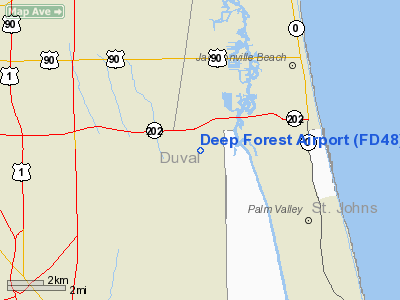
12 nautical miles E of Jacksonville, FL |
|
Location: |
Duval County, FL |
|
Magnetic Variation: |
03W (1985) |
Owner
& Manager
|
Ownership: |
Privately owned |
|
Owner: |
George Hodges, Jr. |
|
Address: |
Po Box 16771
Jacksonville, FL 32245-6771 |
|
Phone number: |
904-699-0251 |
|
Manager: |
John R. Cathey |
|
Address: |
5101 Hodges Blvd.
Jacksonville, FL 32245-7393 |
|
Phone number: |
904-223-0153 |
Airport
Operations and Facilities
|
Airport Use: |
Private |
|
Wind
indicator: |
Yes |
|
Segmented
Circle: |
No |
|
Control
Tower: |
No |
|
Lighting
Schedule: |
PHONE REQ
FOR MIRL RY 18/36 CALL 904-641-1916. |
|
Landing fee charge: |
No |
|
Sectional chart: |
Jacksonville |
|
Region: |
ASO - Southern |
|
Boundary ARTCC: |
ZJX - Jacksonville |
|
Tie-in FSS: |
GNV - Gainesville |
|
FSS on Airport: |
No |
|
FSS Phone: |
850-377-3291 |
|
FSS Toll Free: |
1-800-WX-BRIEF |
Airport
Services
|
Runway Information
Runway 18/36
|
Dimension: |
6425 x 60 ft / 1958.3 x 18.3 m |
|
Surface: |
ASPH, |
|
Edge
Lights: |
Non-standard lighting system
NSTD MIRL; INNER 5000 FT PORTION OF RY LGTD WITH WHITE LGTS; DSPLCD
THLDS LGTD WITH BLUE LGTS; THLD LGTD WITH RED LGTS. |
|
|
Runway 18 |
Runway 36 |
|
Traffic
Pattern: |
Left |
Left |
|
Displaced
threshold: |
700.00 ft |
700.00 ft |
|
Radio Navigation
Aids
|
ID |
Type |
Name |
Ch |
Freq |
Var |
Dist |
|
EYA |
NDB |
Eastport |
|
357.00 |
03W |
13.7 nm |
|
HEG |
NDB |
Herlong |
|
332.00 |
02W |
18.8 nm |
|
JA |
NDB |
Dinns |
|
344.00 |
03W |
22.6 nm |
|
IAK |
NDB |
Palatka |
|
243.00 |
05W |
40.1 nm |
|
NRB |
TACAN |
Mayport |
051X |
|
03W |
8.9 nm |
|
NIP |
TACAN |
Jacksonville |
19X |
|
04W |
11.7 nm |
|
NZC |
TACAN |
Cecil/dcmsnd |
088X |
|
04W |
21.9 nm |
|
VQQ |
VOR |
Cecil |
|
117.90 |
03W |
23.0 nm |
|
SGJ |
VOR/DME |
St Augustine |
031X |
109.40 |
06W |
18.2 nm |
|
CRG |
VORTAC |
Craig |
092X |
114.50 |
03W |
6.6 nm |
|
SSI |
VORTAC |
Brunswick |
035X |
109.80 |
04W |
48.6 nm |
|
JAX |
VOT |
Jacksonville Intl |
|
111.00 |
|
19.5 nm |
Remarks
Based Aircraft
|
Aircraft
based on field: |
2 |
|
Single
Engine Airplanes: |
1 |
|
Jet Engine
Airplanes: |
1 |
Deep Forest Airport
Address:
Duval County, FL
Tel:
904-699-0251, 904-223-0153
Images
and information placed above are from
http://www.airport-data.com/airport/FD48/
We
thank them for the data!
| General
Info |
| Country |
United
States |
| State |
FLORIDA
|
| FAA ID |
FD48
|
| Latitude |
30-14-30.870N
|
| Longitude |
081-26-59.307W
|
| Elevation |
24 feet
|
| Near City |
JACKSONVILLE
|
We don't guarantee the information is fresh and accurate. The data may
be wrong or outdated.
For more up-to-date information please refer to other sources.
|
|


