 |
|
| Charlotte County Airport |
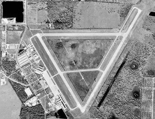 |
| USGS aerial photo as of 6 January 1999 |
| IATA: PGD – ICAO: KPGD – FAA LID: PGD |
| Summary |
| Airport type |
Public |
| Owner |
Charlotte County Airport Authority (Charlotte County, Florida) |
| Serves |
Charlotte County, Florida |
| Location |
Charlotte County, near Punta Gorda, Florida |
| Elevation AMSL |
26 ft / 8 m |
| Coordinates |
26°55′11″N 081°59′26″W / 26.91972°N 81.99056°W / 26.91972; -81.99056 |
| Website |
www.FlyPGD.com |
| Runways |
| Direction |
Length |
Surface |
| ft |
m |
| 4/22 |
6,695 |
2,041 |
Asphalt |
| 15/33 |
5,688 |
1,734 |
Asphalt |
| 9/27 |
5,044 |
1,537 |
Asphalt |
| 9/27 available distance |
2,630 |
802 |
Asphalt |
| Statistics (2006) |
| Aircraft operations |
74,743 |
| Based aircraft |
295 |
| Sources: FAA, airport website
Updated runway distance Airnav.com,
|
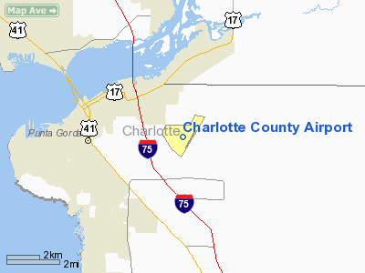
Charlotte County Airport (IATA: PGD, ICAO: KPGD, FAA LID: PGD) is a public airport located 3 mi (5 km) southeast of the central business district of Punta Gorda, in Charlotte County, Florida, United States. It is owned by the Charlotte County Airport Authority.
Charlotte County Airport has mainly been used anywhere from deplanements of single engine planes to small jet aircraft and is home to the Florida International Air Show, an annual event which has featured various military demonstration teams, such as the United States Navy's Flight Demonstration Squadron, the "Blue Angels"; the "U.S. Air Force Thunderbirds"; and the United States Army's "Sky Soldiers" (173rd Airborne Brigade Combat Team) Cobra helicopter team.
Charlotte County Airport has serviced several commercial airline tenants throughout its existence, but saw no major commercial operations after the early 1980s in the aftermath of the Airline Deregulation Act of 1978. Commercial operations again commenced at PGD in 2007 when both Skybus Airlines and DayJet began providing flights to and from the airport. Service by these airlines, however, proved to be temporary at best. The larger of the two airlines, Skybus, ceased operations on April 5, 2008, citing a lack of monetary capital to sustain further service. DayJet followed suit on September 19, 2008, citing similar reasons.
Beginning on November 22, 2008, Direct Air, operating brand new Airbus A319 and A320 aircraft from Sir Richard Branson's US airline venture Virgin America, initiated significant commercial service out of PGD, providing a total of eight flights a week from the airport.
On December 2, 2008 low-cost airline Allegiant Air announced it will open a new focus city at PGD. On March 5, 2009 Allegiant started service with McDonnell Douglas MD-80 series aircraft to Greenville, SC and on the following day, March 6, began service to McGhee Tyson Airport in Knoxville, TN. Allegiant offers 4 flights a week out of PGD: 2 to Knoxville, and 2 to Greenville. Airlines and destinations
| Airlines |
Destinations |
| Allegiant Air |
Grand Rapids [begins November 18], Greensboro [begins November 18], Greenville/Spartanburg, Knoxville, Lexington [begins November 19] |
| Direct Air operated by Xtra Airways |
Allentown, Chicago-Rockford, Kalamazoo, Myrtle Beach, Melbourne (FL), Niagara Falls, Plattsburgh, Springfield (IL), Toledo, Worcester |
Facilities and aircraft
Charlotte County Airport covers an area of 1,934 acres (783 ha) which contains three asphalt paved runways: 4/22 measuring 6,695 × 150 ft (2,041 × 46 m), 15/33 measuring 5,688 × 150 ft (1,734 × 46 m), and 9/27 measuring 2,630 × 60 ft (802 × 18 m).
For the 12-month period ending December 31, 2006, the airport had 74,743 aircraft operations, an average of 204 per day: 97% general aviation, 3% air taxi and <1% military. There are 295 aircraft based at this airport: 82% single-engine, 11% multi-engine, 2% jet, 2% helicopter and 2% ultralight.
World War II
In 1941, just prior to the beginning of World War II, the US Army Corps of Engineers planned and constructed an airfield on the current airport property as a combat pilot training base for the US Army Air Forces' Third Air Force, naming the facility Punta Gorda Army Airfield. By 1944, the base reached its peak in housing 1,000 personnel, including two squadrons of student pilots.
The base initially had forty Curtis P-40 Warhawk aircraft assigned, later transitioning to the North American P-51 Mustang aircraft. Pursuit (i.e., "fighter") aircraft training in the P-40 and P-51 represented advanced phase training for Army Air Forces fighter pilots prior to their being deployed with USAAF operational units in the European and Pacific Theaters of Operation. Punta Gorda Army Airfield was a subordinate command of 3rd Air Force, 3rd Fighter Command at Drew Field (now Tampa International Airport), and also had C-45 Expeditor and C-47 Skytrain transport aircraft assigned for support purposes.
All base officers and some senior non-commissioned officers lived in Punta Gorda, while all student officers and most enlisted men lived in tent structures on the base. Semi-permanent buildings included an operations headquarters, classrooms, supply building, fire station, dispensary, chapel and the control tower. The base also had nose dock hangars, where just the nose of the aircraft was under shelter for repairs.
Following the war, the US Government issued a Deed of Release transferring all of the fixtures and improvements situated on the property to the local jursidiction of Charlotte County.
The above content comes from Wikipedia and is published under free licenses – click here to read more.
Location
& QuickFacts
|
FAA
Information Effective: |
2007-01-18 |
|
Airport
Identifier: |
PGD |
|
Airport
Status: |
Operational |
|
Longitude/Latitude: |
081-59-24.8000W/26-55-05.8000N
-81.990222/26.918278 (Estimated) |
|
Elevation: |
26 ft / 7.92 m (Surveyed) |
|
Land: |
1934 acres |
|
From
nearest city: |
3 nautical miles SE of Punta Gorda, FL |
|
Location: |
Charlotte County, FL |
|
Magnetic Variation: |
03W (1990) |
Owner
& Manager
|
Ownership: |
Publicly owned |
|
Owner: |
Charlotte County Arpt Auth |
|
Address: |
28000 A-1 Airport Rd
Punta Gorda, FL 33982 |
|
Phone
number: |
941-639-1101 |
|
Manager: |
Gary Quill |
|
Address: |
28000 A-1 Airport Rd
Punta Gorda, FL 33982 |
|
Phone number: |
941-639-1101 |
Airport
Operations and Facilities
|
Airport
Use: |
Open to public |
|
Wind
indicator: |
Yes |
|
Segmented
Circle: |
Yes |
|
Control
Tower: |
No |
|
Lighting
Schedule: |
DUSK-DAWN
HIRL RY 03/21 AND MIRL RY 15/33 PRESET ON LOW INTST; TO
INCR INTST AND ACTVT PAPI RYS 03 AND 21, PAPI RYS 15 AND
33 AND REIL RYS 21 AND 33 - CTAF. |
|
Beacon
Color: |
Clear-Green (lighted land airport)
ROTATING BEACON OUT OF SERVICE INDEFINITELY. |
|
Landing
fee charge: |
No |
|
Sectional
chart: |
Miami |
|
Region: |
ASO - Southern |
|
Boundary
ARTCC: |
ZMA - Miami |
|
Tie-in
FSS: |
PIE - Saint Petersburg |
|
FSS
on Airport: |
No |
|
FSS
Toll Free: |
1-800-WX-BRIEF |
|
NOTAMs
Facility: |
PGD (NOTAM-d service avaliable) |
|
Certification
type/date: |
I L U 08/1975
CLSD TO ACR OPNS WITH MORE THAN 30 PSGR SEATS EXCP PPR CALL
AMGR 941-639-1101. RY 09/27 CLSD TO ACR OPNS. TRAFFIC PATTERN
ALTITUDE 1000' |
|
Federal Agreements: |
NGPRY3 |
Airport
Communications
|
CTAF: |
122.975 |
|
Unicom: |
122.975 |
Airport
Services
|
Fuel
available: |
100LLA A+
AFTER HRS FUEL AVBL, CTC NUMBERS POSTED AT FBO. 100LL SELF
SERVICE. |
|
Airframe
Repair: |
MAJOR |
|
Power
Plant Repair: |
MAJOR |
|
Bottled
Oxygen: |
NONE |
|
Bulk
Oxygen: |
NONE |
|
Runway Information
Runway 03/21
|
Dimension: |
6695 x 150 ft / 2040.6 x 45.7 m |
|
Surface: |
ASPH, Good Condition |
|
Surface
Treatment: |
Saw-cut or plastic Grooved |
|
Weight
Limit: |
Single wheel: 45000 lbs.
Dual wheel: 95000 lbs.
Dual tandem wheel: 150000 lbs.
Dual dual tandem wheel: 420000 lbs. |
|
Edge
Lights: |
High |
|
|
Runway 03 |
Runway 21 |
|
Longitude: |
081-59-29.0478W |
081-58-52.9957W |
|
Latitude: |
26-54-40.9551N |
26-55-38.8494N |
|
Elevation: |
23.00
ft |
26.00 ft |
|
Alignment: |
29 |
127 |
|
Traffic
Pattern: |
Left |
Left |
|
Markings: |
Non-precision instrument, Good Condition |
Non-precision instrument, Good Condition |
|
Crossing
Height: |
47.00 ft |
31.00 ft |
|
VASI: |
4-light PAPI on left side
RY 03 PAPI OUT OF SERVICE INDEFINITELY. |
4-light PAPI on left side |
|
Visual
Glide Angle: |
3.00� |
3.00� |
|
Runway
End Identifier: |
Yes |
Yes |
|
Obstruction: |
9 ft trees, 648.0 ft from runway, 50:1 slope
to clear |
, 50:1 slope to clear |
|
Runway 09/27
|
Dimension: |
5044 x 150 ft / 1537.4 x 45.7 m |
|
Surface: |
ASPH, Poor Condition |
|
Weight
Limit: |
Single wheel: 45000 lbs.
Dual wheel: 80000 lbs.
Dual tandem wheel: 140000 lbs.
Dual dual tandem wheel: 420000 lbs. |
|
|
Runway 09 |
Runway 27 |
|
Longitude: |
081-59-56.6746W |
081-59-00.9587W |
|
Latitude: |
26-55-24.5812N |
26-55-25.2992N |
|
Elevation: |
19.00
ft |
24.00 ft |
|
Alignment: |
89 |
127 |
|
Traffic
Pattern: |
Left |
Left |
|
Markings: |
Basic, Poor Condition |
Basic, Poor Condition |
|
Obstruction: |
37 ft trees, 2175.0 ft from runway, 50:1 slope
to clear |
18 ft tree, 1127.0 ft from runway, 50:1 slope
to clear |
|
Runway 15/33
|
Dimension: |
5688 x 150 ft / 1733.7 x 45.7 m |
|
Surface: |
ASPH, Good Condition |
|
Weight
Limit: |
Single wheel: 45000 lbs.
Dual wheel: 80000 lbs.
Dual
tandem wheel: 140000 lbs. |
|
Edge
Lights: |
Medium |
|
|
Runway 15 |
Runway 33 |
|
Longitude: |
081-59-57.0482W |
081-59-24.8548W |
|
Latitude: |
26-55-25.1890N |
26-54-36.8123N |
|
Elevation: |
18.00
ft |
23.00
ft |
|
Alignment: |
127 |
127 |
|
Traffic
Pattern: |
Left |
Left |
|
Markings: |
Non-precision instrument, Good Condition |
Non-precision instrument, Good Condition |
|
Crossing
Height: |
43.00 ft |
31.00 ft |
|
Displaced
threshold: |
561.00 ft |
0.00
ft |
|
VASI: |
4-light PAPI on left side |
4-light PAPI on left side |
|
Visual
Glide Angle: |
3.00� |
3.00� |
|
Runway
End Identifier: |
Yes
RY 15 REIL OTS INDEF. |
Yes
RY 33 REIL OUT OF SERVICE INDEFINITELY. |
|
Obstruction: |
30 ft trees, 1248.0 ft from runway, 34:1 slope
to clear |
31 ft trees, 1260.0 ft from runway, 34:1 slope
to clear |
|
Radio Navigation
Aids
|
ID |
Type |
Name |
Ch |
Freq |
Var |
Dist |
|
VNC |
NDB |
Venice |
|
206.00 |
02W |
25.1 nm |
|
CHN |
NDB |
Wauchula |
|
261.00 |
04W |
36.0 nm |
|
APF |
NDB |
Naples |
|
201.00 |
03W |
47.3 nm |
|
PGD |
VOR |
Punta Gorda |
|
110.20 |
03W |
0.1 nm |
|
CYY |
VOR/DME |
Cypress |
023X |
108.60 |
03W |
47.4 nm |
|
RSW |
VORTAC |
Lee County |
055X |
111.80 |
02W |
26.0 nm |
|
LBV |
VORTAC |
La Belle |
041X |
110.40 |
01E |
32.6 nm |
|
SRQ |
VORTAC |
Sarasota |
099X |
115.20 |
02W |
41.7 nm |
Remarks
- ARRIVING
JET ACFT & ALL ACFT OVER 12,500 LBS MAINTAIN 2000 FT AGL UNTIL ESTABLISHED
ON FINAL APCH.
Based Aircraft
|
Aircraft
based on field: |
230 |
|
Single
Engine Airplanes: |
159 |
|
Multi
Engine Airplanes: |
41 |
|
Jet Engine
Airplanes: |
16 |
|
Helicopters: |
7 |
|
Ultralights: |
7 |
Operational Statistics
Time Period:
2004-01-02 - 2004-12-31
|
Aircraft
Operations: |
173/Day |
|
Air Taxi: |
6.9% |
|
General
Aviation Local: |
66.1% |
|
General
Aviation Itinerant: |
26.8% |
|
Military: |
0.3% |
Charlotte County Airport
Address:
Charlotte County, FL
Tel:
941-639-1101
Images
and information placed above are from
http://www.airport-data.com/airport/PGD/
We
thank them for the data!
| General
Info |
| Country |
United
States |
| State |
FLORIDA
|
| FAA ID |
PGD
|
| Latitude |
26-55-12.700N
|
| Longitude |
081-59-25.900W
|
| Elevation |
25 feet
|
| Near City |
PUNTA
GORDA |
We don't guarantee the information is fresh and accurate. The data may
be wrong or outdated.
For more up-to-date information please refer to other sources.
|
|


