 |
|
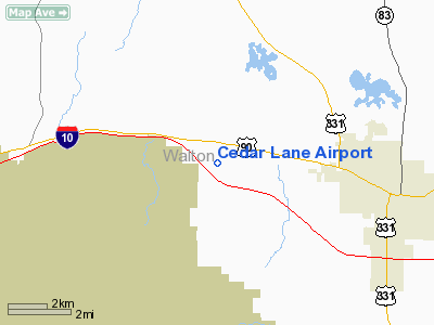
Location
& QuickFacts
|
FAA
Information Effective: |
2007-01-18 |
|
Airport
Identifier: |
5FL9 |
|
Airport
Status: |
Operational |
|
Longitude/Latitude: |
086-12-46.7960W/30-44-10.6810N
-86.212999/30.736300 (Estimated) |
|
Elevation: |
270 ft / 82.30 m (Estimated) |
|
Land: |
9 acres |
|
From
nearest city: |
7 nautical miles SW of Defuniak Springs,
FL |
|
Location: |
Walton County, FL |
|
Magnetic Variation: |
00E (1985) |
Owner
& Manager
|
Ownership: |
Privately owned |
|
Owner: |
Maurice Roberts |
|
Address: |
460 Boy Scout Road
Defuniak Springs, FL 32435 |
|
Phone
number: |
850-892-3953 |
|
Manager: |
Maurice Roberts |
|
Address: |
460 Boy Scout Road
Defuniak Springs, FL 32435 |
|
Phone number: |
850-892-3953 |
Airport
Operations and Facilities
|
Airport
Use: |
Private |
|
Wind
indicator: |
Yes |
|
Segmented
Circle: |
No |
|
Control
Tower: |
No |
|
Sectional
chart: |
New Orleans |
|
Region: |
ASO - Southern |
|
Boundary
ARTCC: |
ZJX - Jacksonville |
|
Tie-in
FSS: |
GNV - Gainesville |
|
FSS
Phone: |
850-377-3291 |
|
FSS
Toll Free: |
1-800-WX-BRIEF |
|
Runway Information
Runway 01/19
|
Dimension: |
2415 x 100 ft / 736.1 x 30.5 m |
|
Surface: |
TURF, |
|
|
Runway 01 |
Runway 19 |
|
Traffic
Pattern: |
Left |
Left |
|
Displaced
threshold: |
600.00 ft |
500.00 ft |
|
Obstruction: |
30 ft trees |
40 ft trees, 300.0 ft from runway |
|
Radio Navigation
Aids
|
ID |
Type |
Name |
Ch |
Freq |
Var |
Dist |
|
DTS |
NDB |
Destin |
|
254.00 |
01W |
24.1 nm |
|
BKK |
NDB |
Tri County |
|
275.00 |
02W |
32.3 nm |
|
JUY |
NDB |
Judd |
|
264.00 |
02W |
35.4 nm |
|
OZ |
NDB |
Ruckr |
|
212.00 |
00E |
35.8 nm |
|
BVG |
NDB |
Boll Weevil |
|
352.00 |
03E |
38.0 nm |
|
LOR |
NDB |
Lowe |
|
269.00 |
03W |
44.6 nm |
|
HYE |
NDB |
Hanchey |
|
221.00 |
00E |
47.7 nm |
|
XBR |
NDB |
Brantley |
|
410.00 |
00E |
49.8 nm |
|
DWG |
TACAN |
Warrington |
002X |
|
00E |
22.2 nm |
|
HRT |
TACAN |
Hurlburt |
045X |
|
00E |
30.9 nm |
|
NGS |
TACAN |
Santa Rosa |
063X |
|
01E |
38.2 nm |
|
NSE |
TACAN |
Whiting |
070X |
|
01E |
41.6 nm |
|
FYL |
VOR |
Tri County |
|
108.40 |
08W |
31.9 nm |
|
UIA |
VOR |
Andalusia |
|
110.20 |
00E |
35.7 nm |
|
EDN |
VOR |
Enterprise |
|
116.60 |
03W |
37.2 nm |
|
HEY |
VOR |
Hanchey |
|
110.60 |
02E |
48.0 nm |
|
OZR |
VOR/DME |
Cairns |
049X |
111.20 |
02E |
40.7 nm |
|
CEW |
VORTAC |
Crestview |
106X |
115.90 |
03E |
24.7 nm |
|
PFN |
VORTAC |
Panama City |
090X |
114.30 |
00W |
41.7 nm |
Remarks
- PRVDD
ALL APCH/DEP OPNS CONDUCTED IN VFR WX CONDITIONS; PRIVATE USE; ALL OPNS
MUST REMAIN CLEAR OF THE RESTRICTED AREA UNLESS PPR.
Based Aircraft
|
Aircraft
based on field: |
1 |
|
Single
Engine Airplanes: |
1 |
Cedar Lane Airport
Address:
Walton County, FL
Tel:
850-892-3953
Images
and information placed above are from
http://www.airport-data.com/airport/5FL9/
We
thank them for the data!
| General
Info |
| Country |
United
States |
| State |
FLORIDA
|
| FAA ID |
5FL9
|
| Latitude |
30-44-10.681N
|
| Longitude |
086-12-46.796W
|
| Elevation |
270 feet
|
| Near City |
DEFUNIAK
SPRINGS |
We don't guarantee the information is fresh and accurate. The data may
be wrong or outdated.
For more up-to-date information please refer to other sources.
|
|


