|
|
| Cecil Field |
| IATA: NZC – ICAO: KVQQ – FAA LID: VQQ |
| Summary |
| Airport type |
Public |
| Owner |
Jacksonville Aviation Authority |
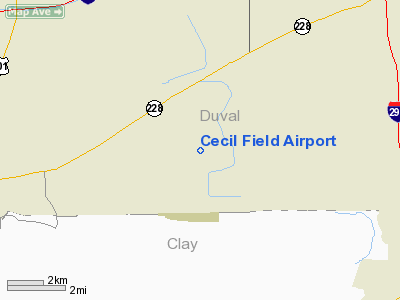
| Location |
Jacksonville, Florida |
| Elevation AMSL |
81 ft / 25 m |
| Coordinates |
30°13′07″N 081°52′36″W / 30.21861°N 81.87667°W / 30.21861; -81.87667 |
| Website |
jaa.aero/AirSys/CF.aspx |
| Runways |
| Direction |
Length |
Surface |
| ft |
m |
| 9L/27R |
8,002 |
2,439 |
Asphalt/Concrete |
| 9R/27L |
8,003 |
2,439 |
Asphalt/Concrete |
| 18L/36R |
12,504 |
3,811 |
Asphalt/Concrete |
| 18R/36L |
8,003 |
2,439 |
Asphalt–concrete |
| Statistics (1999) |
| Aircraft operations |
64,255 |
| Based aircraft |
107 |
| Source: Federal Aviation Administration |
Cecil Field (IATA: NZC, ICAO: KVQQ, FAA LID: VQQ) is a public joint civil-military airport located in Jacksonville, a city in Duval County, Florida, United States. The airport is owned by the Jacksonville Aviation Authority and services military aircraft, corporate aircraft, general aviation, and air cargo. The Florida Army National Guard's primary Army Aviation Support Facility and the U.S. Coast Guard's Helicopter Interdiction Tactical Squadron (HITRON) are also located here, the former operating CH-47 Chinook, UH-60 Blackhawk and C-12 Huron aircraft, while the latter operates the MH-65C Dolphin helicopter.
Cecil Field, commonly known as either "Cecil" or "Cecil Commerce Center", also houses the FSCJ (Florida State College Jacksonville) aviation course hangar and associated training aircraft. Facilities operated by major aerospace firms such as Boeing and Northrop Grumman are also located at Cecil, providing major maintenance and overhaul services for a variety of U.S. military aircraft.
In 2010, Cecil Field became the United States' eighth licensed commercial spaceport and the first in Florida authorized to fly space vehicles that take off and land horizontally.
Although most U.S. airports use the same three-letter location identifier for the FAA and IATA, Cecil Field is assigned VQQ by the FAA and NZC by the IATA. The airport's ICAO identifier is KVQQ. The NZC identifier was the airport's previous FAA identifier when it was Naval Air Station Cecil Field, its former name until its closure as a naval air station in 1999.
History
The airport is located on the site of the former Naval Air Station Cecil Field, which opened in 1941 and closed in 1999 following the 1993 Base Realignment and Closure (BRAC) decision. Covering a total area of 22,939 acres (92.8 km²), it was the largest military base in the Jacksonville area and supported all Atlantic Fleet F/A-18 Hornet strike fighter squadrons and S-3 Viking sea control squadrons.
Facilities and aircraft
Cecil Field covers an area of 6,000 acres (24 km²) and contains four runways:
- Runway 9L/27R: 8,002 x 200 ft. (2,439 x 61 m), Surface: Asphalt/Concrete
- Runway 9R/27L: 8,003 x 200 ft. (2,439 x 61 m), Surface: Asphalt/Concrete
- Runway 18L/36R: 12,504 x 200 ft. (3,811 x 61 m), Surface: Asphalt/Concrete
- Runway 18R/36L: 8,003 x 200 ft. (2,439 x 61 m), Surface: Asphalt/Concrete
For 12-month period ending September 30, 1999, the airport had 64,255 aircraft operations, an average of 176 per day: 73% military (46,783) and 27% general aviation (17,472). There are 107 aircraft based at this airport: 64% military (69), 16% jet aircraft (17), 10% single engine (11) and 9% helicopters (10).
The above content comes from Wikipedia and is published under free licenses – click here to read more.
|
 |
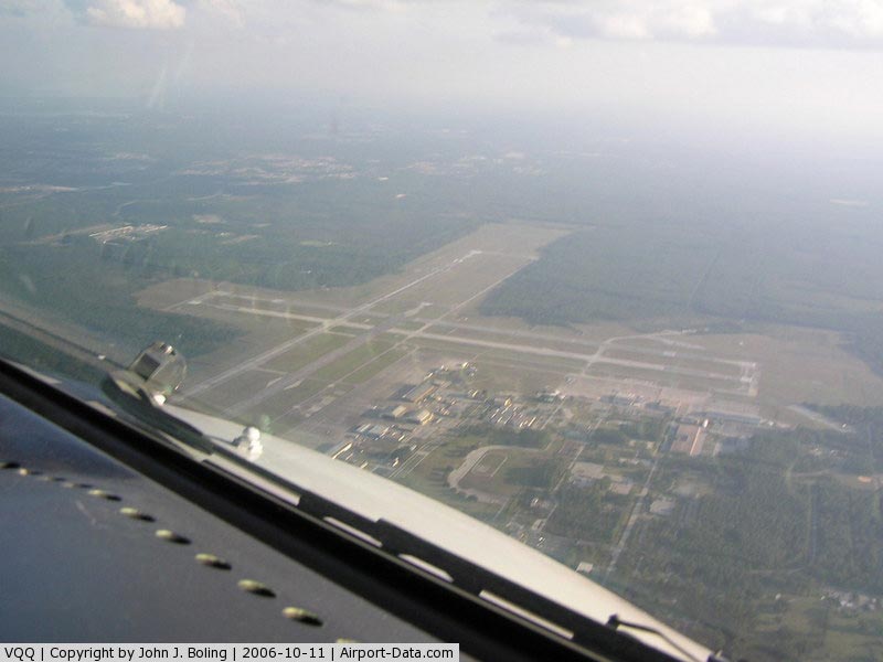
(Click on the photo to enlarge) |
|
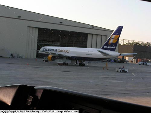 |
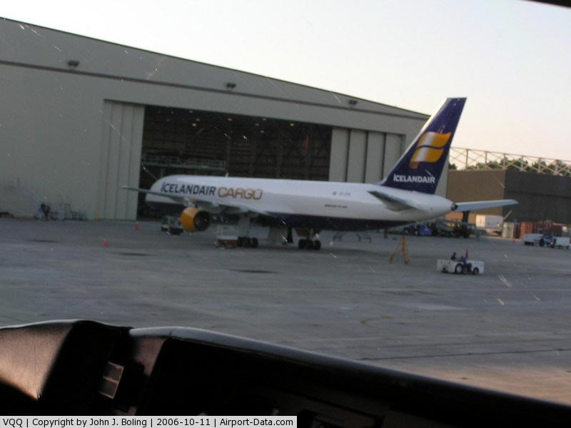
(Click on the photo to enlarge) |
Location
& QuickFacts
|
FAA
Information Effective: |
2006-09-28 |
|
Airport
Identifier: |
VQQ |
|
Longitude/Latitude: |
081-52-36.1840W/30-13-07.2810N
-81.876718/30.218689 (Estimated) |
|
Elevation: |
81 ft / 24.69 m (Surveyed) |
|
Land: |
6000 acres |
|
From
nearest city: |
0 nautical miles N of Jacksonville, FL |
|
Location: |
Duval County, FL |
|
Magnetic Variation: |
03W (1990) |
Owner
& Manager
|
Ownership: |
Publicly owned |
|
Owner: |
Jacksonville Airport Authority |
|
Address: |
Po Box 18018
Jacksonville, FL 32229-0018 |
|
Phone number: |
904-573-1601 |
|
Manager: |
Rusty Chandler |
|
Address: |
13365 Aeronautical Circle
Jacksonville, FL 32221 |
|
Phone number: |
904-573-1613 |
Airport
Operations and Facilities
|
Airport
Use: |
Open to public |
|
Wind
indicator: |
Yes |
|
Segmented
Circle: |
No |
|
Control
Tower: |
Yes |
|
Attendance
Schedule: |
ALL/ALL/0700-2200 |
|
Lighting
Schedule: |
DUSK-DAWN
WHEN ATCT CLSD ACTVT HIRL RY 18L/36R, HIRL RY 09R/27L, REIL
RYS 09R, 27L, 18L & MALSR RY 36R - CTAF. |
|
Beacon
Color: |
Clear-Green (lighted land airport) |
|
Sectional
chart: |
Jacksonville |
|
Region: |
ASO - Southern |
|
Boundary
ARTCC: |
ZJX - Jacksonville |
|
Tie-in
FSS: |
GNV - Gainesville |
|
FSS
on Airport: |
No |
|
FSS
Phone: |
850-377-3291 |
|
FSS
Toll Free: |
1-800-WX-BRIEF |
|
NOTAMs
Facility: |
VQQ (NOTAM-d service avaliable) |
|
Certification type/date: |
?? ??/???? |
|
Federal Agreements: |
N |
Airport
Communications
|
CTAF: |
126.100 |
|
Unicom: |
122.950 |
Airport
Services
|
Fuel
available: |
100LLA1+ |
|
Airframe
Repair: |
MAJOR |
|
Power
Plant Repair: |
MAJOR |
|
Bottled
Oxygen: |
HIGH/LOW |
|
Bulk
Oxygen: |
HIGH |
|
Runway Information
Runway 09L/27R
|
Dimension: |
8002 x 200 ft / 2439.0 x 61.0 m |
|
Surface: |
ASPH-CONC, |
|
|
Runway 09L |
Runway 27R |
|
Longitude: |
081-53-30.0600W |
081-51-58.8600W |
|
Latitude: |
30-13-03.2700N |
30-13-03.8900N |
|
Elevation: |
81.00 ft |
67.00 ft |
|
Alignment: |
90 |
127 |
|
Traffic
Pattern: |
Left |
Left |
|
Markings: |
Non-precision instrument, Good Condition |
Non-precision instrument, Good Condition |
|
Obstruction: |
, 50:1 slope to clear |
19 ft trees, 1140.0 ft from runway, 50:1 slope
to clear |
|
Runway 09R/27L
|
Dimension: |
8003 x 200 ft / 2439.3 x 61.0 m |
|
Surface: |
ASPH-CONC, |
|
Edge
Lights: |
High |
|
|
Runway 09R |
Runway 27L |
|
Longitude: |
081-53-29.9900W |
081-51-58.7800W |
|
Latitude: |
30-12-56.3400N |
30-12-56.9600N |
|
Elevation: |
78.00 ft |
65.00 ft |
|
Alignment: |
90 |
127 |
|
Traffic
Pattern: |
Left |
Left |
|
Markings: |
Non-precision instrument, Good Condition |
Non-precision instrument, Good Condition |
|
Crossing
Height: |
77.00 ft |
72.00 ft |
|
VASI: |
4-light PAPI on left side |
4-light PAPI on left side |
|
Visual
Glide Angle: |
3.00� |
3.00� |
|
Runway
End Identifier: |
Yes |
Yes |
|
Obstruction: |
41 ft trees, 1836.0 ft from runway, 40:1 slope
to clear |
19 ft trees, 1140.0 ft from runway, 50:1 slope
to clear |
|
Runway 18L/36R
|
Dimension: |
12504 x 200 ft / 3811.2 x 61.0 m |
|
Surface: |
ASPH-CONC, |
|
Edge
Lights: |
High |
|
|
Runway 18L |
Runway 36R |
|
Longitude: |
081-52-26.7800W |
081-52-25.6700W |
|
Latitude: |
30-14-06.0800N |
30-12-02.3200N |
|
Elevation: |
80.00 ft |
73.00 ft |
|
Alignment: |
127 |
127 |
|
ILS
Type: |
|
ILS/DME |
|
Traffic
Pattern: |
Left |
Left |
|
Markings: |
Precision instrument, Poor Condition
RY 18L/36R MARKINGS FADED DUE TO RUBBER BUILDUP. |
Precision instrument, Good Condition |
|
Crossing
Height: |
80.00 ft |
73.00 ft |
|
VASI: |
4-light PAPI on left side |
4-light PAPI on left side |
|
Visual
Glide Angle: |
3.00� |
3.00� |
|
Approach
lights: |
|
MALSR |
|
Runway
End Identifier: |
Yes |
No |
|
Obstruction: |
42 ft trees, 2300.0 ft from runway, 50:1 slope
to clear |
36 ft tree, 2000.0 ft from runway, 50:1 slope
to clear |
|
Runway 18R/36L
|
Dimension: |
8003 x 200 ft / 2439.3 x 61.0 m |
|
Surface: |
ASPH-CONC, |
|
|
Runway 18R |
Runway 36L |
|
Longitude: |
081-52-34.7600W |
081-52-34.0400W |
|
Latitude: |
30-14-06.0300N |
30-12-46.8200N |
|
Elevation: |
80.00 ft |
71.00 ft |
|
Alignment: |
127 |
127 |
|
Traffic
Pattern: |
Left |
Left |
|
Markings: |
Non-precision instrument, Good Condition |
Non-precision instrument, Good Condition |
|
Obstruction: |
42 ft trees, 2300.0 ft from runway, 50:1 slope
to clear |
42 ft trees, 6000.0 ft from runway, 50:1 slope
to clear |
|
Radio Navigation
Aids
|
ID |
Type |
Name |
Ch |
Freq |
Var |
Dist |
|
HEG |
NDB |
Herlong |
|
332.00 |
02W |
4.9 nm |
|
JA |
NDB |
Dinns |
|
344.00 |
03W |
15.3 nm |
|
EYA |
NDB |
Eastport |
|
357.00 |
03W |
18.5 nm |
|
IAK |
NDB |
Palatka |
|
243.00 |
05W |
34.2 nm |
|
GN |
NDB |
Wynds |
|
269.00 |
04W |
36.4 nm |
|
LCQ |
NDB |
Lake City |
|
204.00 |
03W |
36.5 nm |
|
NZC |
TACAN |
Cecil/dcmsnd |
088X |
|
04W |
0.3 nm |
|
NIP |
TACAN |
Jacksonville |
19X |
|
04W |
10.5 nm |
|
NRB |
TACAN |
Mayport |
051X |
|
03W |
25.7 nm |
|
VQQ |
VOR |
Cecil |
|
117.90 |
03W |
0.8 nm |
|
SGJ |
VOR/DME |
St Augustine |
031X |
109.40 |
06W |
32.5 nm |
|
CRG |
VORTAC |
Craig |
092X |
114.50 |
03W |
20.4 nm |
|
GNV |
VORTAC |
Gators |
109X |
116.20 |
04W |
37.8 nm |
|
TAY |
VORTAC |
Taylor |
076X |
112.90 |
03W |
39.1 nm |
|
JAX |
VOT |
Jacksonville Intl |
|
111.00 |
|
19.1 nm |
Remarks
- CTN-GLIDER
OPER TO 6000' DUR DALGT HR VIC HERLONG APT 5NM NE.
- ARNG:
PPR FOR RAMP ACCESS, DSN 860-7728, OPTION 5. OPR 1300-2130Z++ MON-FRI,
EXC HOL. TRAN ACFT MUST CTC ARNG OPS ON 40.9, 139.3 OR 248.2 BEFORE
ENTRY TO PRK RAMP.
- WILDLIFE
INVOF ARPT.
- GCO
AVBL ON FREQ 121.725 THRU JAX CLEARANCE DELIVERY AND GNV AFSS.
- MISC:
ACFT INBD FOR THE BOEING AEROSPACE SUPPORT CENTER SHOULD CTC EITHER
BOEING AIR OPS (904-317-2438/2425) OR THE GOVT FLT REPRESENTATIVE (904-317-2478)
TO COORDINATE ARRIVAL.
- MISC:
CTC BOEING AIR OPS ON 123.475 OR 264.65 WHEN 15 MINUTES OUT. NML OPERATING
HRS ARE 0700-1800L MON-FRI. PPR FOR SAT DEL. CLSD
SUN.
- TXY
C CLSD AT MILITARY GATE.
- TXY
M CLSD EXCEPT FOR MILITARY ACFT.
- FUEL:
A+ (AIRKAMAN CECIL, INC, AVBL 1300-0100Z++, C904-777-6675.)
(NC-100LL)
- MISC:
CLASS D AIRSPACE EFF 1200-0200Z++, OT CLASS G.
Based Aircraft
|
Aircraft
based on field: |
107 |
|
Single
Engine Airplanes: |
11 |
|
Jet Engine
Airplanes: |
17 |
|
Helicopters: |
10 |
|
Military: |
69 |
Operational Statistics
|
Aircraft
Operations: |
177/Day |
|
General
Aviation Local: |
14.1% |
|
General
Aviation Itinerant: |
13.1% |
|
Military: |
72.8% |
Cecil Field Airport
Address:
Duval County, FL
Tel:
904-573-1601, 904-573-1613
Images
and information placed above are from
http://www.airport-data.com/airport/VQQ/
We
thank them for the data!
| General
Info |
| Country |
United
States |
| State |
FLORIDA
|
| FAA ID |
VQQ
|
| Latitude |
30-13-07.223N
|
| Longitude |
081-52-35.992W
|
| Elevation |
81 feet
|
| Near City |
JACKSONVILLE
|
We don't guarantee the information is fresh and accurate. The data may
be wrong or outdated.
For more up-to-date information please refer to other sources.
|
|