|
 |
|
||||
|
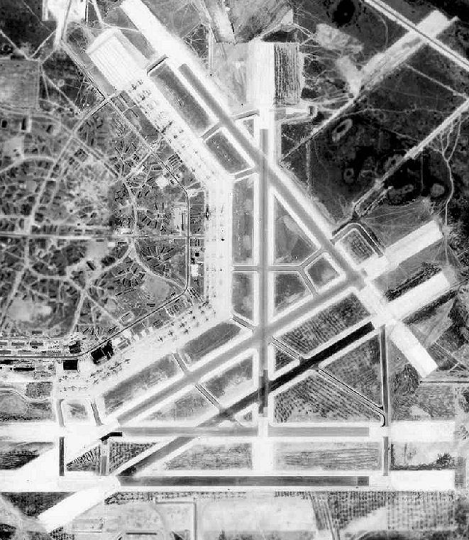
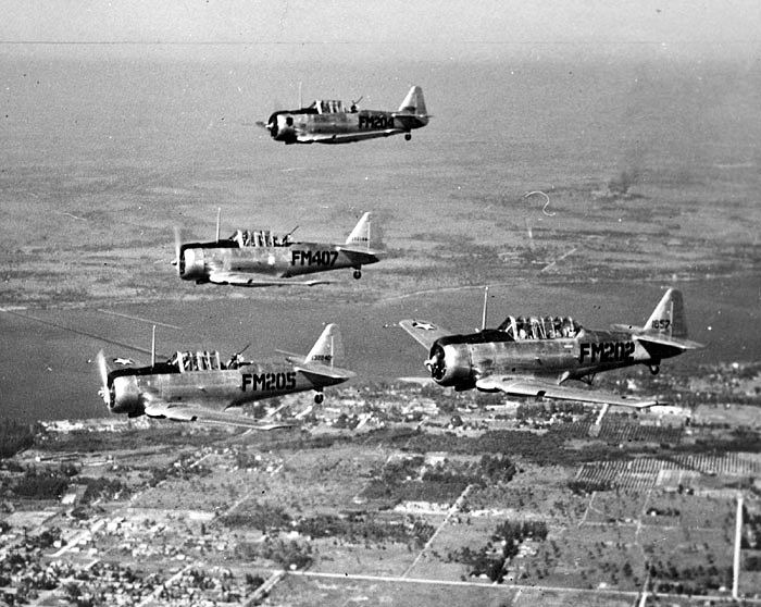
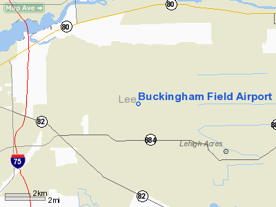
Buckingham Field (FAA LID: FL59) is a private-use airport located seven nautical miles (13 km) east of the central business district of Fort Myers, in Lee County, Florida, United States. It is privately owned by the Lee County Mosquito Control District. HistoryWartime useOriginally constructed as Buckingham Army Airfield, the airfield had its origins as an aircraft gunner training base to train the aerial gunners who would defend bombers. The airfield was constructed starting in 1942 at a cost of $10 million on a total of 7,000 acres (28 km) of swamp land, which had to be drained with an extensive system of newly constructed canals. The airfield originally had three 5,000' runways, with 2 oval tracks of the Ground Moving Target Range, located to the west of the airfield, as well as nearby skeet ranges & trap ranges. Buckingham Field was initially assigned to the AAF Southeast Training Center as a flexible gunnery school. Training was conducted in both air-to-air & air-to-surface gunnery. The air-to-air training used a variety of aircraft, including AT-6 Texans, BT-13 Valiants, P-63 Kingcobras, B-17 Flying Fortresses and B-24 Liberators. For ground-based training, a number of facilities were available, including the moving target ranges and a number of gunnery simulators. On 8 January 1943, the War Department constituted and activated the 75th Flying Training Wing (Flexible Gunnery) at Buckingham and assigned it to the AAF Eastern Flying Training Command. Most of the B-24s that flew the oil refinery raids over Ploesti, Romania came from Buckingham. When the mission idea came down, most of the B-24 crews were from Buckingham as they were experienced, with their gunners in the middle of frangible bullet training. The training program consisted of having P-39 and other aircraft outfitted with an extra layer of armor plating so that gunners could fire the bullets right at the aircraft instead of at tow targets. At its peak, Buckingham Field base housed 16,000 men. By the end of World War II the airfield consisted of a total of six concrete runways (the largest was 5,800' long), along with a large concrete ramp area. The airfield and its target ranges covered a total of 65,723 acres (265.97 km), and had approximately 700 buildings. Buckingham closed in 1945, after graduating almost 48,000 aerial gunners. Postwar Civil useAfter the war, the barracks at Buckingham were briefly used as the Edison College, but this closed in 1948. Most of the buildings of the original base were subsequently removed over time. A street grid for a planned housing development named Lehigh Acres was eventually built over the area formerly occupied by Buckingham's runways in the 1950s. By the mid-1970s, the runways were gone except for the concrete ends. The 1978 Miami Sectional Chart depicted three paved portions of Buckingham's former ramp as the runways of the Lehigh Acres West private airfield. The longest runway was depicted as 3,000'. The street grid built over the location of the former runways remained undeveloped for some period of time, before eventually being partially filled in with houses, it remains, however, about 90% unoccupied. By 2000, the northern portion of the ramp was to used as a runway, being operated as a private field, Buckingham Field Airport, by the Lee County Mosquito/Hyacinth Control District, which operates a fleet of 23 aircraft & helicopters (including C-47s & several rare C-117 Super Dakotas). Portions of the ramp area are also used for automobile racing. FacilitiesBuckingham Field has two concrete paved runways: 14/32 measuring 4,046 x 400 ft (1,233 x 122 m) and 6/24 measuring 2,726 x 400 ft (831 x 122 m). The above content comes from Wikipedia and is published under free licenses – click here to read more.
Runway InformationRunway 06/24
Runway 14/32
Radio Navigation Aids
Remarks
Based Aircraft
Buckingham Field Airport Address: Lee County, FL Tel: 941-694-2174 Images
and information placed above are from We thank them for the data!
We don't guarantee the information is fresh and accurate. The data may
be wrong or outdated.
|
||||||||||||||||||||||||||||||||||||||||||||||||||||||||||||||||||||||||||||||||||||||||||||||||||||||||||||||||||||||||||||||||||||||||||||||||||||||||||||||||||||||||||||||||||||||||||||||||||||||||||||||||||||||||||||||||||||||||||||||||||||||||||||||||||||||||||||

 |
|
Copyright 2004-2024 © by Airports-Worldwide.com, Vyshenskoho st. 36, Lviv 79010, Ukraine Legal Disclaimer |