 |
|
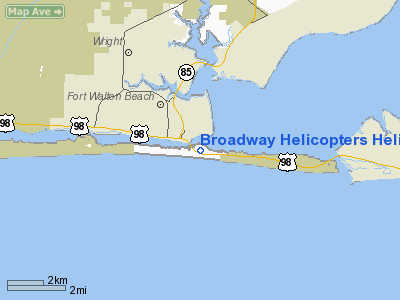
Broadway Helicopters Heliport |
Location
& QuickFacts
|
FAA
Information Effective: |
2006-09-28 |
|
Airport
Identifier: |
FA14 |
|
Longitude/Latitude: |
086-35-38.8290W/30-23-51.7190N
-86.594119/30.397700 (Estimated) |
|
Elevation: |
10 ft / 3.05 m (Estimated) |
|
Land: |
0 acres |
|
From
nearest city: |
5 nautical miles N of Fort Walton Beach,
FL |
|
Location: |
Okaloosa County, FL |
|
Magnetic Variation: |
00E (1990) |
Owner
& Manager
|
Ownership: |
Privately owned |
|
Owner: |
Harry Robinson |
|
Address: |
3773 Chestnut Ridge Lane
Birmingham, AL 35216 |
|
Phone
number: |
205-226-6914 |
|
Manager: |
Carlos Zayas |
|
Address: |
Leeside Inn
Ft Walton Beach, FL 32548 |
|
Phone number: |
904-243-7359 |
Airport
Operations and Facilities
|
Airport
Use: |
Private |
|
Wind
indicator: |
Yes |
|
Segmented
Circle: |
No |
|
Control
Tower: |
No |
|
Attendance
Schedule: |
APR-AUG/MON-SAT/0900-2200 |
|
Lighting
Schedule: |
DUSK-2200 |
|
Sectional
chart: |
New Orleans |
|
Region: |
ASO - Southern |
|
Boundary
ARTCC: |
ZJX - Jacksonville |
|
Tie-in
FSS: |
GNV - Gainesville |
|
FSS
on Airport: |
No |
|
FSS
Phone: |
850-377-3291 |
|
FSS
Toll Free: |
1-800-WX-BRIEF |
|
Runway Information
Helipad H1
|
Dimension: |
50 x 50 ft / 15.2 x 15.2 m |
|
Surface: |
ASPH, Fair Condition |
|
|
Runway H1 |
Runway |
|
Traffic
Pattern: |
Left |
Left |
|
Radio Navigation
Aids
|
ID |
Type |
Name |
Ch |
Freq |
Var |
Dist |
|
DTS |
NDB |
Destin |
|
254.00 |
01W |
6.3 nm |
|
PKZ |
NDB |
Pickens |
|
326.00 |
01E |
30.4 nm |
|
HRT |
TACAN |
Hurlburt |
045X |
|
00E |
5.3 nm |
|
DWG |
TACAN |
Warrington |
002X |
|
00E |
6.1 nm |
|
NGS |
TACAN |
Santa Rosa |
063X |
|
01E |
22.1 nm |
|
NSE |
TACAN |
Whiting |
070X |
|
01E |
29.4 nm |
|
NPA |
TACAN |
Pensacola |
119X |
|
01E |
37.5 nm |
|
NUN |
VOR |
Saufley |
|
108.80 |
01E |
38.7 nm |
|
CEW |
VORTAC |
Crestview |
106X |
115.90 |
03E |
26.1 nm |
|
PFN |
VORTAC |
Panama City |
090X |
114.30 |
00W |
48.6 nm |
Remarks
- VFR;
PRIVATE USE; OPERATIONS ARE CONDUCTED FROM 270 DEG TO 350 DEG &
FROM 90 DEG TO 140 DEG; AREA IS MARKED; WIND INDICATOR IS MAINTAINED.
Based Aircraft
|
Aircraft
based on field: |
1 |
|
Helicopters: |
1 |
Broadway Helicopters Heliport
Address:
Okaloosa County, FL
Tel:
205-226-6914,
904-243-7359
Images
and information placed above are from
http://www.airport-data.com/airport/FA14/
We
thank them for the data!
| General
Info |
| Country |
United
States |
| State |
FLORIDA
|
| FAA ID |
FA14
|
| Latitude |
30-23-51.719N
|
| Longitude |
086-35-38.829W
|
| Elevation |
10 feet
|
| Near City |
FORT WALTON
BEACH |
We don't guarantee the information is fresh and accurate. The data may
be wrong or outdated.
For more up-to-date information please refer to other sources.
|
|


