 |
|
Coordinates: 30°46′43.80″N 086°31′19.60″W / 30.778833°N 86.522111°W / 30.778833; -86.522111
| Bob Sikes Airport |
| IATA: CEW – ICAO: KCEW – FAA LID: CEW |
| Summary |
| Airport type |
Public use |
| Owner |
Okaloosa County, Florida |
| Operator |
Greg Donovan |
| Serves |
Crestview, Florida |
| Location |
Okaloosa County, Florida |
| Elevation AMSL |
213 ft / 65 m |
| Website |
Bob Sikes Airport Website |
| Runways |
| Direction |
Length |
Surface |
| ft |
m |
| 17/35 |
8,005 |
2,440 |
Asphalt |
| Statistics (2000) |
| Aircraft operations |
48,600 |
| Based aircraft |
49 |
| Source: Federal Aviation Administration |
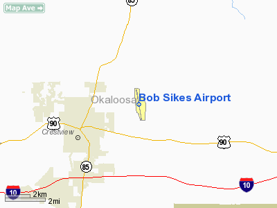
Bob Sikes Airport (IATA: CEW, ICAO: KCEW, FAA LID: CEW), named for Robert L. F. Sikes, is a public-use airport located 3 miles (4.8 km) northeast of the central business district of the city of Crestview in Okaloosa County, Florida, United States. The airport is publicly owned and supports a mix of general aviation and aerospace corporations performing modification work on military aircraft. The airport sees frequent military training use by aircraft based at Eglin AFB, Duke Field, Hurlburt Field, NAS Pensacola, NAS Whiting Field and Fort Rucker.
The above content comes from Wikipedia and is published under free licenses – click here to read more.
Location
& QuickFacts
|
FAA
Information Effective: |
2006-09-28 |
|
Airport
Identifier: |
CEW |
|
Longitude/Latitude: |
086-31-19.6000W/30-46-43.8000N
-86.522111/30.778833 (Estimated) |
|
Elevation: |
213 ft / 64.92 m (Surveyed) |
|
Land: |
1080 acres |
|
From
nearest city: |
3 nautical miles NE of Crestview, FL |
|
Location: |
Okaloosa County, FL |
|
Magnetic Variation: |
00E (1985) |
Owner
& Manager
|
Ownership: |
Publicly owned |
|
Owner: |
Okaloosa County |
|
Address: |
County Courthouse
Crestview, FL 32536 |
|
Phone
number: |
850-682-2711 |
|
Manager: |
Jerry Sealy |
|
Address: |
Okaloosa Rgnl Airport
Eglin Afb, FL 32542 |
|
Phone number: |
850-651-7160
ADNL PHONE (850) 682-6811. |
Airport
Operations and Facilities
|
Airport
Use: |
Open to public |
|
Wind
indicator: |
Yes |
|
Segmented
Circle: |
No |
|
Control
Tower: |
No |
|
Attendance
Schedule: |
ALL/ALL/ALL |
|
Lighting
Schedule: |
DUSK-DAWN
ACTVT MIRL RY 17/35 - CTAF. |
|
Beacon
Color: |
Clear-Green (lighted land airport) |
|
Landing
fee charge: |
No |
|
Sectional
chart: |
New Orleans |
|
Region: |
ASO - Southern |
|
Boundary
ARTCC: |
ZJX - Jacksonville |
|
Tie-in
FSS: |
GNV - Gainesville |
|
FSS
on Airport: |
No |
|
FSS
Phone: |
850-377-3291 |
|
FSS
Toll Free: |
1-800-WX-BRIEF |
|
NOTAMs
Facility: |
CEW (NOTAM-d service avaliable) |
|
Federal Agreements: |
NGY |
Airport
Communications
|
CTAF: |
122.950 |
|
Unicom: |
122.950 |
Airport
Services
|
Fuel
available: |
100LLA A1+
FOR FUEL AFT 1900 CALL (850) 682-6811. |
|
Airframe
Repair: |
MAJOR |
|
Power
Plant Repair: |
MAJOR |
|
Bottled
Oxygen: |
HIGH |
|
Bulk
Oxygen: |
HIGH |
|
Runway Information
Runway 17/35
|
Dimension: |
8005 x 150 ft / 2439.9 x 45.7 m |
|
Surface: |
ASPH, Good Condition |
|
Weight
Limit: |
Single wheel: 60000 lbs.
Dual wheel: 120000 lbs.
Dual
tandem wheel: 170000 lbs. |
|
Edge
Lights: |
Medium |
|
|
Runway 17 |
Runway 35 |
|
Longitude: |
086-31-26.7893W |
086-31-12.4256W |
|
Latitude: |
30-47-22.9187N |
30-46-04.6622N |
|
Elevation: |
213.00 ft |
153.00 ft |
|
Alignment: |
127 |
127 |
|
ILS
Type: |
ILS |
|
|
Traffic
Pattern: |
Left |
Left |
|
Markings: |
Precision instrument, Good Condition |
Non-precision instrument, Fair Condition |
|
Crossing
Height: |
40.00 ft |
52.00 ft |
|
VASI: |
4-light PAPI on right side |
4-light PAPI on right side |
|
Visual
Glide Angle: |
3.00� |
3.00� |
|
Obstruction: |
28 ft trees, 1160.0 ft from runway, 34:1 slope
to clear |
18 ft trees, 956.0 ft from runway, 100 ft right
of centerline, 42:1 slope to clear |
|
Radio Navigation
Aids
|
ID |
Type |
Name |
Ch |
Freq |
Var |
Dist |
|
DTS |
NDB |
Destin |
|
254.00 |
01W |
22.6 nm |
|
JUY |
NDB |
Judd |
|
264.00 |
02W |
32.3 nm |
|
PKZ |
NDB |
Pickens |
|
326.00 |
01E |
39.7 nm |
|
BVG |
NDB |
Boll Weevil |
|
352.00 |
03E |
43.5 nm |
|
OZ |
NDB |
Ruckr |
|
212.00 |
00E |
45.2 nm |
|
BKK |
NDB |
Tri County |
|
275.00 |
02W |
47.7 nm |
|
XBR |
NDB |
Brantley |
|
410.00 |
00E |
48.5 nm |
|
DWG |
TACAN |
Warrington |
002X |
|
00E |
18.1 nm |
|
HRT |
TACAN |
Hurlburt |
045X |
|
00E |
22.8 nm |
|
NGS |
TACAN |
Santa Rosa |
063X |
|
01E |
23.6 nm |
|
NSE |
TACAN |
Whiting |
070X |
|
01E |
25.8 nm |
|
NPA |
TACAN |
Pensacola |
119X |
|
01E |
48.3 nm |
|
UIA |
VOR |
Andalusia |
|
110.20 |
00E |
32.6 nm |
|
EDN |
VOR |
Enterprise |
|
116.60 |
03W |
44.5 nm |
|
NUN |
VOR |
Saufley |
|
108.80 |
01E |
45.9 nm |
|
FYL |
VOR |
Tri County |
|
108.40 |
08W |
47.3 nm |
|
CEW |
VORTAC |
Crestview |
106X |
115.90 |
03E |
8.6 nm |
Remarks
- ARPT
USED BY MIL FOR FLT TEST & TRNG. EXTSV VFR MIL STUDENT INSTR TRNG
CONDUCTED IN ALL QUADRANTS OF CEW NAVAIDS. ARRG
VFR ACFT SHOULD MONITOR 122.95.
- TGL
NOT RECOMMENDED; EXPEDITE TURN OFF ASAP.
- NOISE
ABATEMENT PROCEDURES: DEPG ACFT MAINTAIN RY HDG TO 700 FT MSL BEFORE
TURNING.
- PARALLEL
TXY LGTS OTS INDEFLY.
- PAEW
ADJ TO ALL TWYS INDEFLY.
Based Aircraft
|
Aircraft
based on field: |
49 |
|
Single
Engine Airplanes: |
35 |
|
Multi
Engine Airplanes: |
13 |
|
Jet Engine
Airplanes: |
1 |
Operational Statistics
|
Aircraft
Operations: |
134/Day |
|
Air Taxi: |
0.4% |
|
General
Aviation Local: |
31.7% |
|
General
Aviation Itinerant: |
59.7% |
|
Military: |
8.2% |
Bob Sikes Airport
Address:
Okaloosa County, FL
Tel:
850-682-2711,
850-651-7160
Images
and information placed above are from
http://www.airport-data.com/airport/CEW/
We
thank them for the data!
| General
Info |
| Country |
United
States |
| State |
FLORIDA
|
| FAA ID |
CEW
|
| Latitude |
30-46-43.800N
|
| Longitude |
086-31-19.600W
|
| Elevation |
213 feet
|
| Near City |
CRESTVIEW
|
We don't guarantee the information is fresh and accurate. The data may
be wrong or outdated.
For more up-to-date information please refer to other sources.
|
|


