|
 |
|
||||
|
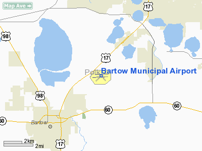
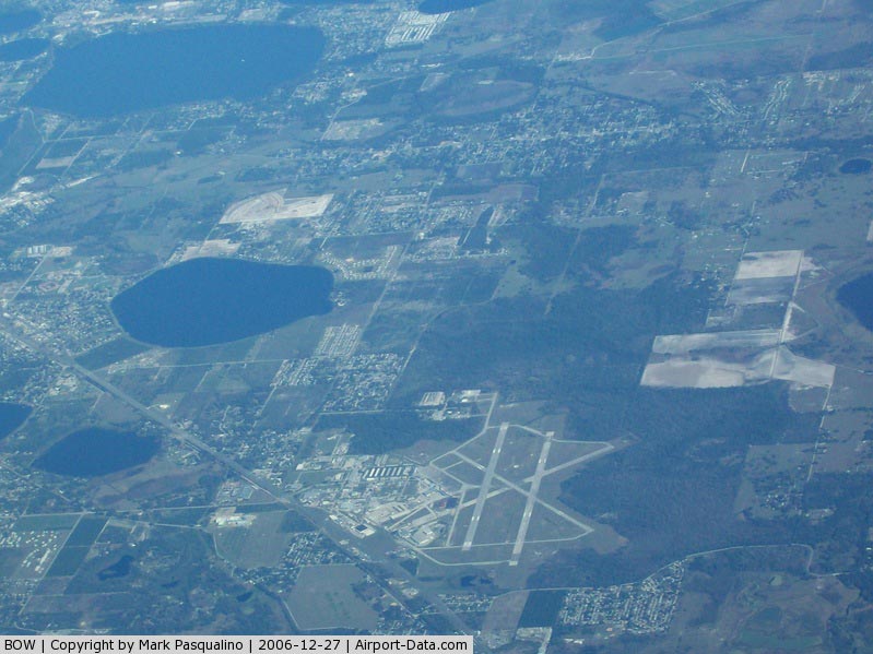
Bartow Municipal Airport (IATA: BOW, ICAO: KBOW, FAA LID: BOW) is a public use airport located four miles (6 km) northeast of the central business district of Bartow, a city in Polk County, Florida, United States. It is owned by the Bartow Municipal Airport Development Authority. Facilities and AircraftBartow Municipal Airport covers an area of 1,624 acres (657 ha) which contains three asphalt paved runways:
Bartow Municipal is a controlled airport with an FAA Level I contract Air Traffic Control Tower in daily operation from 0730 to 1730 local time. For the 12-month period ending July 15, 2002, the airport had 49,368 aircraft operations, an average of 135 per day: 100% general aviation and <1% military. There are 115 aircraft based at this airport: 82% single engine, 9% multi-engine, 4% jet aircraft and 5% helicopters. General Aviation TerminalAirport Services
100LL Full Service 100 LL Self Service JetA Prist
HistoryIn 1941, Bartow Mayor C.E. Williams spearheaded the city's initial land acquisition for what would become the Bartow Municipal Airport. In 1942, the US Government took over this site and subsequently developed it into a training field for the U.S. Army Air Forces. Throughout World War II, the field was used for the training of pilots. Originally planned as an operational training station for medium bombardment aircraft such as the B-26 Marauders that operated from nearby MacDill Field in Tampa and Lakeland Army Air Field/Drane Field in Lakeland, Bartow Army Air Base was changed to a Fighter Replacement Training Station as of February 15, 1943. It provided facilities for a fighter group and two fighter squadrons of P-51 Mustang aircraft, a base headquarters, air base squadron, aviation squadron, guard squadron and sub-depot. The base was ordered to deactivate on 25 October 1945 and the deactivation was completed and the base closed by the end of the year. The airport was then returned to the City of Bartow by the General Services Administration (GSA). It was stipulated by GSA that the airport must continue be used as an airport for aviation purposes; and if not, that it be returned to the U.S. Government. Through the years 1945 to 1950, a fixed base operator (FBO) ran the airfield and flight line portion of the airport, while the large complex of support buildings that had been constructed by the Federal Government was used by industry and for storage. In 1946, approximately 32 former military barracks were converted into apartments for returning military veterans. In 1950, the U.S. Government exercised its reversal clause for the facility and again took over control of the airport. The Department of Defense concurrently called for bids from civilian contractors to man and operate a primary pilot training school for U.S. Air Force student pilots. Renamed Bartow Air Base, the installation served as a USAF primary flight training facility for the Air Training Command (ATC) from 1951 to 1960, during which time its 3303rd Pilot Training Group operated the T-6 Texan, T-34 Mentor and T-28 Trojan, training both commissioned USAF officers and USAF aviation cadets. More than 8,000 men graduated from primary flight training at Bartow AB before proceeding on to select air force bases for advanced training in aircraft such as the T-33 Shooting Star for jet pilots or the TB-25 and B-25 Mitchell for multiengine pilots. Notable graduates of primary flight training at Bartow AB included astronauts Colonel Edwin E. "Buzz" Aldrin, Jr. and Lieutenant Colonel Edward White II, as well as former Assistant Vice Chief of Staff of the Air Force, Lieutenant General Thomas G. McInerney and the first graduate of the USAF Academy to achieve 4-star rank, General Hansford T. Johnson. Garner Aviation was the successful bidder on the first Air Force training contract and operated the facility until 1955 when they lost the bid to Truman Miller. Miller ran the training school until 1960, when the Air Force discontinued the contract primary pilot training concept and began phasing out T-34 and T-28 training in favor of the USAF Undergraduate Pilot Training (UPT) system that was being put in place at larger air force bases that could readily accommodate the T-37 and T-38 Talon jet trainers then coming on line. Bartow Air Base was gradually deactivated as a USAF facility throughout 1960, with the City of Bartow incrementally gaining control of more and more of the facility. USAF operations officially ended in 1961 and the facility was totally transferred to the city once again by the GSA. Forty years later, a retired USAF T-37 was loaned to the city and the airport by the National Museum of the United States Air Force and placed on a permanent static display pylon as a memorial to the former U.S. Army Air Forces and U.S. Air Force presence at Bartow. The T-37 is located near the former air base main gate, now the current entrance to the airport, and The Museum Room in the airport's main terminal also commemorates the airport's military heritage. From 1960 through 1967 the City of Bartow again managed the airport and the aviation facilities were leased yet again to a fixed base operator. In 1964, the City made a formal request to the Federal Aviation Administration for authority to convert a large building area into an industrial park. The concept was approved and the industrial park was opened. In July 1967, the City of Bartow passed an ordinance which established an airport authority, its official name being the Bartow Municipal Airport Development Authority. The Authority was composed of five city commission members and an executive director. Bartow Municipal Airport and Industrial Park has been self-supporting since its inception. Utilizing its aircraft refueling, storage facilities and Industrial Park to obtain its revenues, the Authority has maintained the facility as a public use general aviaton airport. The above content comes from Wikipedia and is published under free licenses – click here to read more.
Runway InformationRunway 05/23
Runway 09L/27R
Runway 09R/27L
Radio Navigation Aids
Remarks
Based Aircraft
Operational Statistics
Bartow Municipal Airport Address: Polk County, FL Tel: 863-533-1195 Images
and information placed above are from We thank them for the data!
We don't guarantee the information is fresh and accurate. The data may
be wrong or outdated.
|
||||||||||||||||||||||||||||||||||||||||||||||||||||||||||||||||||||||||||||||||||||||||||||||||||||||||||||||||||||||||||||||||||||||||||||||||||||||||||||||||||||||||||||||||||||||||||||||||||||||||||||||||||||||||||||||||||||||||||||||||||||||||||||||||||||||||||||||||||||||||||||||||||||||||||||||||||||||||||||||||||||||||||||||||||||||||||||||||||||||||||||||||||||||||||||||||||||||||||||||||||||||||||||||||||||||||||||||||||

 |
|
Copyright 2004-2024 © by Airports-Worldwide.com, Vyshenskoho st. 36, Lviv 79010, Ukraine Legal Disclaimer |