 |
|
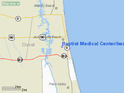
Baptist Medical Center / Beaches Heliport |
|
|
Location
& QuickFacts
|
FAA
Information Effective: |
2006-09-28 |
|
Airport
Identifier: |
45FD |
|
Longitude/Latitude: |
081-23-54.3020W/30-16-22.8700N
-81.398417/30.273019 (Estimated) |
|
Elevation: |
17 ft / 5.18 m (Estimated) |
|
Land: |
1 acres |
|
From
nearest city: |
1 nautical miles S of Jacksonville Beach,
FL |
|
Location: |
Duval County, FL |
|
Magnetic Variation: |
04W (1990) |
Owner
& Manager
|
Ownership: |
Privately owned |
|
Owner: |
Baptist Medical Ctr/beaches |
|
Address: |
1350 13th Ave. So.
Jacksonville Beach, FL 32250 |
|
Phone
number: |
904-247-2925 |
|
Manager: |
Jerry L Miller |
|
Address: |
1350 13th Ave. So.
Jacksonville Beach, FL 32250 |
|
Phone number: |
904-247-2925 |
Airport
Operations and Facilities
|
Airport
Use: |
Private
MEDICAL USE. |
|
Segmented
Circle: |
No |
|
Control
Tower: |
No |
|
Attendance
Schedule: |
ALL/ALL/ALL |
|
Lighting
Schedule: |
PHONE REQ
FOR PERIMETER; TOUCHDOWN AND LDIN LIGHTS CALL 904-247-2925. |
|
Sectional
chart: |
Jacksonville |
|
Region: |
ASO - Southern |
|
Boundary
ARTCC: |
ZJX - Jacksonville |
|
Tie-in
FSS: |
GNV - Gainesville |
|
FSS
on Airport: |
No |
|
FSS
Phone: |
850-377-3291 |
|
FSS
Toll Free: |
1-800-WX-BRIEF |
|
Runway Information
Helipad H1
|
Dimension: |
40 x 40 ft / 12.2 x 12.2 m |
|
Surface: |
CONC, |
|
|
Runway H1 |
Runway |
|
Traffic
Pattern: |
Left |
Left |
|
Radio Navigation
Aids
|
ID |
Type |
Name |
Ch |
Freq |
Var |
Dist |
|
EYA |
NDB |
Eastport |
|
357.00 |
03W |
14.2 nm |
|
HEG |
NDB |
Herlong |
|
332.00 |
02W |
21.3 nm |
|
JA |
NDB |
Dinns |
|
344.00 |
03W |
23.9 nm |
|
IAK |
NDB |
Palatka |
|
243.00 |
05W |
43.0 nm |
|
NRB |
TACAN |
Mayport |
051X |
|
03W |
7.1 nm |
|
NIP |
TACAN |
Jacksonville |
19X |
|
04W |
14.5 nm |
|
NZC |
TACAN |
Cecil/dcmsnd |
088X |
|
04W |
24.7 nm |
|
VQQ |
VOR |
Cecil |
|
117.90 |
03W |
25.8 nm |
|
SGJ |
VOR/DME |
St Augustine |
031X |
109.40 |
06W |
19.2 nm |
|
CRG |
VORTAC |
Craig |
092X |
114.50 |
03W |
7.0 nm |
|
SSI |
VORTAC |
Brunswick |
035X |
109.80 |
04W |
46.8 nm |
|
JAX |
VOT |
Jacksonville Intl |
|
111.00 |
|
20.1 nm |
Remarks
- PVT
USE; OPNS CONDUCTED FROM 220 DEG CLKWS TO 240 DEG AND FROM 300 DEG TO
320 DEG; TKOF/LNDG AREA MKD; WIND INDICATOR MAINTD.
Baptist Medical Center/beaches Heliport
Address:
Duval County, FL
Tel:
904-247-2925
Images
and information placed above are from
http://www.airport-data.com/airport/45FD/
We
thank them for the data!
| General
Info |
| Country |
United
States |
| State |
FLORIDA
|
| FAA ID |
45FD
|
| Latitude |
30-16-22.870N
|
| Longitude |
081-23-54.302W
|
| Elevation |
17 feet
|
| Near City |
JACKSONVILLE
BEACH |
We don't guarantee the information is fresh and accurate. The data may
be wrong or outdated.
For more up-to-date information please refer to other sources.
|
|


