 |
|
Arcadia Municipal Airport |
Coordinates: 27°11′31.18″N 081°50′14.297″W / 27.1919944°N 81.83730472°W / 27.1919944; -81.83730472
| Arcadia Municipal Airport |
| IATA: none – ICAO: none – FAA LID: X06 |
| Summary |
| Airport type |
Public use |
| Owner |
City of Arcadia |
| Operator |
Ed Strube |
| Serves |
Arcadia, Florida |
| Location |
DeSoto County, Florida |
| Elevation AMSL |
60 ft / 18 m |
| Runways |
| Direction |
Length |
Surface |
| ft |
m |
| 5/23 |
3,700 |
1,128 |
Asphalt |
| 13/31 |
2,780 |
847 |
Turf |
| Statistics (1999) |
| Aircraft operations |
19,373 |
| Based aircraft |
31 |
| Source: Federal Aviation Administration |
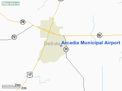
Arcadia Municipal Airport (FAA LID: X06) is a public-use airport located 1 mile (1.6 km) southeast of the central business district of the city of Arcadia in DeSoto County, Florida, United States. The airport is publicly owned.
The above content comes from Wikipedia and is published under free licenses – click here to read more.
Location
& QuickFacts
|
FAA
Information Effective: |
2006-09-28 |
|
Airport
Identifier: |
X06 |
|
Longitude/Latitude: |
081-50-14.2970W/27-11-31.1800N
-81.837305/27.191994 (Estimated) |
|
Elevation: |
60 ft / 18.29 m (Estimated) |
|
Land: |
210 acres |
|
From
nearest city: |
1 nautical miles SE of Arcadia, FL |
|
Location: |
De Soto County, FL |
|
Magnetic Variation: |
02W (1985) |
Owner
& Manager
|
Ownership: |
Publicly owned |
|
Owner: |
City Of Arcadia |
|
Address: |
Box 351
Arcadia, FL 33821 |
|
Phone number: |
863-494-4114 |
|
Manager: |
Ed Strube
CITY ADMINISTRATOR. |
|
Address: |
Po Box 351
Arcadia, FL 33821 |
|
Phone number: |
863-494-4114
863-494-7844 |
Airport
Operations and Facilities
|
Airport
Use: |
Open to public |
|
Wind
indicator: |
Yes |
|
Segmented
Circle: |
No |
|
Control
Tower: |
No |
|
Attendance
Schedule: |
ALL/ALL/0900-1700 |
|
Lighting
Schedule: |
DUSK-DAWN
ACTVT MIRL RY 05/23 - CTAF. |
|
Beacon
Color: |
Clear-Green (lighted land airport)
ARPT BCN OTS INDEFLY. |
|
Landing
fee charge: |
No |
|
Sectional
chart: |
Miami |
|
Region: |
ASO - Southern |
|
Boundary
ARTCC: |
ZMA - Miami |
|
Tie-in
FSS: |
PIE - Saint Petersburg |
|
FSS
on Airport: |
No |
|
FSS
Toll Free: |
1-800-WX-BRIEF |
|
NOTAMs
Facility: |
PIE (NOTAM-d service avaliable) |
|
Federal Agreements: |
NGY |
Airport
Communications
|
CTAF: |
123.000 |
|
Unicom: |
123.000 |
Airport
Services
|
Fuel
available: |
100LLA |
|
Airframe
Repair: |
MAJOR |
|
Power
Plant Repair: |
MAJOR |
|
Bottled
Oxygen: |
NONE |
|
Bulk
Oxygen: |
NONE |
|
Runway Information
Runway 05/23
|
Dimension: |
3700 x 75 ft / 1127.8 x 22.9 m |
|
Surface: |
ASPH, Good Condition |
|
Edge
Lights: |
Medium |
|
|
Runway 05 |
Runway 23 |
|
Traffic
Pattern: |
Left |
Left |
|
Markings: |
Basic, Fair Condition |
Basic, Fair Condition |
|
Obstruction: |
15 ft road, 636.0 ft from runway, 29:1 slope
to clear |
4 ft fence, 200.0 ft from runway, 106 ft right
of centerline
RY 23 APCH RATIO 30:1 TO APCH END RY.
RY 23 4 FT FENCE 175 FT FROM END OF RY & 125 FT RIGHT. |
|
Runway 13/31
|
Dimension: |
2780 x 140 ft / 847.3 x 42.7 m |
|
Surface: |
TURF, Fair Condition |
|
|
Runway 13 |
Runway 31 |
|
Traffic
Pattern: |
Left |
Left |
|
Displaced
threshold: |
775.00 ft
RY 13/31 DSPLCD THLDS MKD WITH 3 YELLOW PAINTED TIRES. |
775.00 ft |
|
Obstruction: |
15 ft road, 100.0 ft from runway
APCH RATIO 20:1 TO DSPLCD THLD FM 56 FT TREES 1125 FT TO DSPLCD
THLD. |
45 ft trees, 125.0 ft from runway, 2:1 slope
to clear
APCH RATIO 20:1 TO DSPLCD THLD FM TREES. |
|
Radio Navigation
Aids
|
ID |
Type |
Name |
Ch |
Freq |
Var |
Dist |
|
CHN |
NDB |
Wauchula |
|
261.00 |
04W |
19.3 nm |
|
VNC |
NDB |
Venice |
|
206.00 |
02W |
32.7 nm |
|
PGD |
VOR |
Punta Gorda |
|
110.20 |
03W |
18.5 nm |
|
LBV |
VORTAC |
La Belle |
041X |
110.40 |
01E |
32.4 nm |
|
RSW |
VORTAC |
Lee County |
055X |
111.80 |
02W |
39.9 nm |
|
SRQ |
VORTAC |
Sarasota |
099X |
115.20 |
02W |
40.2 nm |
|
LAL |
VORTAC |
Lakeland |
107X |
116.00 |
01E |
48.7 nm |
Remarks
Based Aircraft
|
Aircraft
based on field: |
31 |
|
Single
Engine Airplanes: |
26 |
|
Multi
Engine Airplanes: |
2 |
|
Ultralights: |
3 |
Operational Statistics
|
Aircraft
Operations: |
54/Day |
|
Air Taxi: |
0.2% |
|
General
Aviation Local: |
64.5% |
|
General
Aviation Itinerant: |
35.1% |
|
Military: |
0.2% |
Arcadia Municipal Airport
Address:
De Soto County, FL
Tel:
863-494-4114, 863-494-7844
Images
and information placed above are from
http://www.airport-data.com/airport/X06/
We
thank them for the data!
| General
Info |
| Country |
United
States |
| State |
FLORIDA
|
| FAA ID |
X06
|
| Latitude |
27-11-31.180N
|
| Longitude |
081-50-14.297W
|
| Elevation |
60 feet
|
| Near City |
ARCADIA
|
We don't guarantee the information is fresh and accurate. The data may
be wrong or outdated.
For more up-to-date information please refer to other sources.
|
|


