 |
|
Apalachicola Municipal Airport |
| Apalachicola Regional Airport |
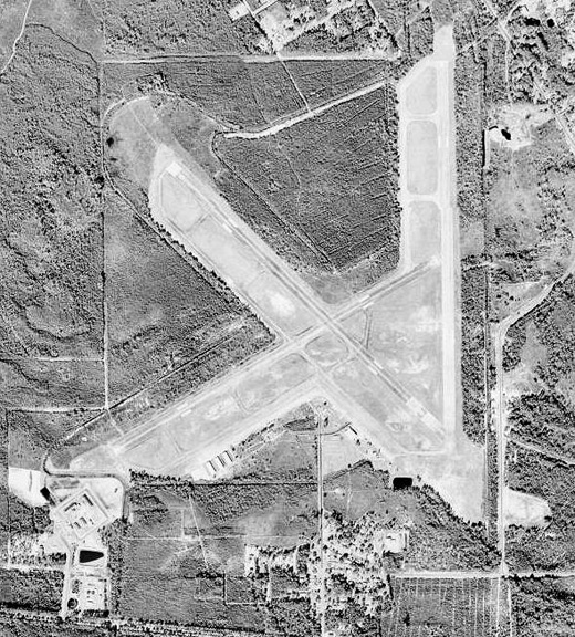 |
| USGS aerial image - 10 July 1999 |
| IATA: AAF – ICAO: KAAF – FAA LID: AAF |
| Summary |
| Airport type |
Public |
| Owner |
Franklin County |
| Serves |
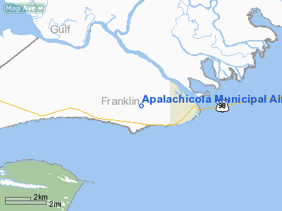
Apalachicola, Florida |
| Elevation AMSL |
20 ft / 6 m |
| Coordinates |
29°43′39″N 085°01′39″W / 29.7275°N 85.0275°W / 29.7275; -85.0275 |
| Website |
www.ApalachicolaAirport.com |
| Runways |
| Direction |
Length |
Surface |
| ft |
m |
| 6/24 |
5,271 |
1,607 |
Concrete |
| 13/31 |
5,251 |
1,601 |
Concrete |
| 18/36 |
5,251 |
1,601 |
Concrete |
| Statistics (2009) |
| Aircraft operations |
24,375 |
| Based aircraft |
18 |
| Source: Federal Aviation Administration |
Apalachicola Regional Airport (IATA: AAF, ICAO: KAAF, FAA LID: AAF) is a county-owned, public-use airport located two nautical miles (3.7 km) west of the central business district of Apalachicola, in Franklin County, Florida, United States. It was previously known at Apalachicola Municipal Airport. The airport supports general aviation activity in the area and provides service via a tenant fixed base operator (FBO). History
It was originally constructed in 1939 as the Army Air Corps. Expanded in February 1942, becoming a Flexible Gunnery School under 2136th Army Air Forces Base Unit, a sub-base and auxiliary airfield to nearby Tyndall Field, the present day Tyndall Air Force Base. Inactivated on 30 September 1945, facility turned over to Army Corps of Engineers on 2 February 1947. Eventually discharged to the War Assets Administration (WAA); deeded to municipality of Apalachicola and becoming a civil airport.
On 15 March 1964, a Blue Angels pilot was killed during an attempted emergency landing at Apalachicola Municipal Airport when his F-11A Tiger experienced difficulties while transiting from West Palm Beach, Florida back to the Blue Angels home base at NAS Pensacola, Florida. Lt. George L. Neale, 29, who flew in the Number Four slot position of the diamond formation, was returning from a demonstration at West Palm Beach with one other of the six team jets and an R5D Skymaster support plane when he radioed Tyndall Air Force Base, near Panama City, Florida, for emergency landing permission when he suffered mechanical problems S of Apalachicola. But, spotting the local airport, he attempted a landing there, ejecting on final approach at 1115 hrs. as the fighter came down ~250 yards short of the runway. Although he cleared the airframe at ~150–200 feet altitude, his chute did not have sufficient time to deploy and he was killed. He was survived by his wife Donna, of Pensacola, Florida, and his mother, Mrs. Katherine Neale, of Avalon, Pennsylvania. The Navy said that the cause of the accident was being investigated.
Facilities and aircraft
Apalachicola Regional Airport covers an area of 1,100 acres (445 ha) at an elevation of 20 feet (6 m) above mean sea level. It has three runways with concrete surfaces: Runway 6/24 is 5,271 by 150 feet (1,607 x 46 m); Runways 13/31 and 18/36 are both 5,251 by 150 feet (1,601 x 46 m).
For the 12-month period ending March 13, 2009, the airport had 24,375 aircraft operations, an average of 66 per day: 94% general aviation, 5% air taxi, and 1% military. At that time there were 18 aircraft based at this airport: 89% single-engine and 11% multi-engine.
The above content comes from Wikipedia and is published under free licenses – click here to read more.
Location
& QuickFacts
|
FAA
Information Effective: |
2006-09-28 |
|
Airport
Identifier: |
AAF |
|
Longitude/Latitude: |
085-01-38.8100W/29-43-39.1700N
-85.027447/29.727547 (Estimated) |
|
Elevation: |
20 ft / 6.10 m (Surveyed) |
|
Land: |
800 acres |
|
From
nearest city: |
2 nautical miles W of Apalachicola, FL |
|
Location: |
Franklin County, FL |
|
Magnetic Variation: |
02W (1995) |
Owner
& Manager
|
Ownership: |
Publicly owned |
|
Owner: |
Franklin County |
|
Address: |
33 Market Street, Suite 203
Apalachicola, FL 32320 |
|
Phone
number: |
850-653-8861 |
|
Manager: |
Kendall Wade
COUNTY CLERK. |
|
Address: |
33 Market Street, Suite 203
Apalachicola, FL 32320 |
|
Phone number: |
850-653-8861 |
Airport
Operations and Facilities
|
Airport
Use: |
Open to public |
|
Wind
indicator: |
Yes |
|
Segmented
Circle: |
No |
|
Control
Tower: |
No |
|
Attendance
Schedule: |
ALL/ALL/0700-1900
CALL OUT FEE FOR ATTENDANT AFTER HRS, 850-653-2670. |
|
Lighting
Schedule: |
DUSK-DAWN
ACTVT MIRL RYS 06/24 & 13/31 - CTAF. |
|
Beacon
Color: |
Clear-Green (lighted land airport) |
|
Landing
fee charge: |
No |
|
Sectional
chart: |
New Orleans |
|
Region: |
ASO - Southern |
|
Boundary
ARTCC: |
ZJX - Jacksonville |
|
Tie-in
FSS: |
GNV - Gainesville |
|
FSS
on Airport: |
No |
|
FSS
Phone: |
850-377-3291 |
|
FSS
Toll Free: |
1-800-WX-BRIEF |
|
NOTAMs
Facility: |
AAF (NOTAM-d service avaliable) |
|
Federal Agreements: |
NR |
Airport
Communications
|
CTAF: |
122.800 |
|
Unicom: |
122.800 |
Airport
Services
|
Fuel
available: |
100LLA |
|
Airframe
Repair: |
MAJOR |
|
Power
Plant Repair: |
MAJOR |
|
Bottled
Oxygen: |
NONE |
|
Bulk
Oxygen: |
NONE |
|
Runway Information
Runway 06/24
|
Dimension: |
5070 x 150 ft / 1545.3 x 45.7 m |
|
Surface: |
CONC, Good Condition |
|
Edge
Lights: |
Medium |
|
|
Runway 06 |
Runway 24 |
|
Longitude: |
085-02-13.9700W |
085-01-24.0100W |
|
Latitude: |
29-43-20.8500N |
29-43-45.7300N |
|
Elevation: |
20.00
ft |
20.00
ft |
|
Alignment: |
60 |
127 |
|
Traffic
Pattern: |
Left |
Left |
|
Markings: |
Basic, Good Condition |
Basic, Good Condition |
|
Crossing
Height: |
40.00 ft |
40.00 ft |
|
VASI: |
2-light PAPI on left side |
2-light PAPI on left side |
|
Visual
Glide Angle: |
3.00� |
3.00� |
|
Obstruction: |
7 ft fence, 345.0 ft from runway, 125 ft right
of centerline, 20:1 slope to clear |
26 ft trees, 720.0 ft from runway, 20:1 slope
to clear |
|
Runway 13/31
|
Dimension: |
5350 x 150 ft / 1630.7 x 45.7 m |
|
Surface: |
CONC, Good Condition |
|
Edge
Lights: |
Medium |
|
|
Runway 13 |
Runway 31 |
|
Longitude: |
085-02-05.5900W |
085-01-22.9000W |
|
Latitude: |
29-43-58.4800N |
29-43-20.8200N |
|
Elevation: |
20.00
ft |
16.00
ft |
|
Alignment: |
127 |
127 |
|
Traffic
Pattern: |
Left |
Left |
|
Markings: |
Non-precision instrument, Fair Condition |
Non-precision instrument, Fair Condition
MARKINGS FADED. |
|
Crossing
Height: |
40.00 ft |
40.00 ft |
|
Displaced
threshold: |
0.00
ft |
400.00 ft |
|
VASI: |
2-light PAPI on left side |
2-light PAPI on left side |
|
Visual
Glide Angle: |
3.00� |
3.00� |
|
Obstruction: |
40 ft trees, 1125.0 ft from runway, 23:1 slope
to clear |
28 ft trees, 540.0 ft from runway, 12:1 slope
to clear
RY 31 APCH RATIO 33:1 TO DSPLCD THLD. |
|
Runway 18/36
|
Dimension: |
5265 x 150 ft / 1604.8 x 45.7 m |
|
Surface: |
CONC, Good Condition |
|
|
Runway 18 |
Runway 36 |
|
Longitude: |
085-01-23.1009W |
085-01-23.4205W |
|
Latitude: |
29-44-11.2012N |
29-43-19.2329N |
|
Elevation: |
16.00
ft |
20.00
ft |
|
Traffic
Pattern: |
Left |
Left |
|
Markings: |
Basic, Fair Condition |
Basic, Good Condition |
|
Displaced
threshold: |
300.00 ft |
500.00 ft |
|
Obstruction: |
72 ft trees, 1140.0 ft from runway, 13:1 slope
to clear
RY 18 APCH RATIO 20:1 TO DSPLCD THLD. |
48 ft trees, 1100.0 ft from runway, 18:1 slope
to clear
RY 36 APCH RATIO 33:1 TO DSPLCD THLD. |
|
Radio Navigation
Aids
|
ID |
Type |
Name |
Ch |
Freq |
Var |
Dist |
|
AAF |
NDB |
Apalachicola |
|
349.00 |
02W |
0.3 nm |
|
PAM |
TACAN |
Tyndall |
124X |
|
00W |
35.2 nm |
|
PFN |
VORTAC |
Panama City |
090X |
114.30 |
00W |
45.0 nm |
Based Aircraft
|
Aircraft
based on field: |
30 |
|
Single
Engine Airplanes: |
28 |
|
Multi
Engine Airplanes: |
1 |
|
Helicopters: |
1 |
Operational Statistics
|
Aircraft
Operations: |
67/Day |
|
Air Taxi: |
5.0% |
|
General
Aviation Local: |
61.5% |
|
General
Aviation Itinerant: |
32.8% |
|
Military: |
0.6% |
Apalachicola Municipal Airport
Address:
Franklin County, FL
Tel:
850-653-8861
Images
and information placed above are from
http://www.airport-data.com/airport/AAF/
We
thank them for the data!
| General
Info |
| Country |
United
States |
| State |
FLORIDA
|
| FAA ID |
AAF
|
| Latitude |
29-43-39.165N
|
| Longitude |
085-01-38.812W
|
| Elevation |
20 feet
|
| Near City |
APALACHICOLA
|
We don't guarantee the information is fresh and accurate. The data may
be wrong or outdated.
For more up-to-date information please refer to other sources.
|
|


