 |
|
| Sussex County Airport |
| IATA: GED – ICAO: KGED – FAA LID: GED |
| Summary |
| Operator |
Sussex County |
| Coordinates |
38°41′21″N 075°21′32″W / 38.68917°N 75.35889°W / 38.68917; -75.35889Coordinates: 38°41′21″N 075°21′32″W / 38.68917°N 75.35889°W / 38.68917; -75.35889 |
| Runways |
| Direction |
Length |
Surface |
| ft |
m |
| 4/22 |
5,000 |
1,524 |
Asphalt |
| 13/31 |
2,330 |
710 |
Concrete |
Sussex County Airport (IATA: GED, ICAO: KGED, FAA LID: GED) is a public airport located two miles (3 km) southeast of the central business district of Georgetown, in Sussex County, Delaware, United States. This general aviation airport is publicly-owned by Sussex County.
Facilities
Sussex County Airport covers 615 acres (249 ha) and has two runways:
- Runway 4/22: 5,000 x 150 ft. (1,524 x 46 m), Surface: Asphalt
- Runway 13/31: 2,330 x 50 ft. (710 x 15 m), Surface: Concrete
Jet fuel is available.
The above content comes from Wikipedia and is published under free licenses – click here to read more.
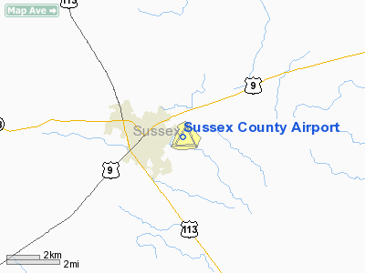
Location
& QuickFacts
|
FAA
Information Effective: |
2006-09-28 |
|
Airport
Identifier: |
GED |
|
Longitude/Latitude: |
075-21-32.0000W/38-41-21.1000N
-75.358889/38.689194 (Estimated) |
|
Elevation: |
50 ft / 15.24 m (Surveyed) |
|
Land: |
615 acres |
|
From
nearest city: |
2 nautical miles SE of Georgetown, DE |
|
Location: |
Sussex County, DE |
|
Magnetic Variation: |
11W (1995) |
Owner
& Manager
|
Ownership: |
Publicly owned |
|
Owner: |
Sussex County Council |
|
Address: |
Po Box 589
Georgetown, DE 19947 |
|
Phone number: |
302-855-7770 |
|
Manager: |
Steve Masten |
|
Address: |
Po Box 589
Georgetown, DE 19947 |
|
Phone number: |
302-855-7770 |
Airport
Operations and Facilities
|
Airport
Use: |
Open to public |
|
Wind
indicator: |
Yes |
|
Segmented
Circle: |
Yes |
|
Control
Tower: |
No |
|
Attendance
Schedule: |
ALL/ALL/0700-2100 |
|
Lighting
Schedule: |
DUSK-DAWN
ACTVT MIRL RY 04/22 & 13/31 & REIL RYS 04 &
22 - 122.95. |
|
Beacon
Color: |
Clear-Green (lighted land airport) |
|
Landing
fee charge: |
No |
|
Sectional
chart: |
Washington |
|
Region: |
AEA - Eastern |
|
Boundary
ARTCC: |
ZDC - Washington |
|
Tie-in
FSS: |
MIV - Millville |
|
FSS
on Airport: |
No |
|
FSS
Phone: |
856-825-8090 |
|
FSS
Toll Free: |
1-800-WX-BRIEF |
|
NOTAMs
Facility: |
GED (NOTAM-d service avaliable) |
|
Federal Agreements: |
NGRY3 |
Airport
Communications
|
CTAF: |
123.000 |
|
Unicom: |
123.000 |
Airport
Services
|
Fuel
available: |
100LLA |
|
Airframe
Repair: |
MAJOR |
|
Power
Plant Repair: |
MAJOR |
|
Bottled
Oxygen: |
NONE |
|
Runway Information
Runway 04/22
|
Dimension: |
5000 x 150 ft / 1524.0 x 45.7 m |
|
Surface: |
ASPH, Good Condition |
|
Edge
Lights: |
Medium |
|
|
Runway 04 |
Runway 22 |
|
Longitude: |
075-21-53.5095W |
075-21-19.2472W |
|
Latitude: |
38-41-02.6057N |
38-41-44.0949N |
|
Elevation: |
49.00 ft |
49.00 ft |
|
Alignment: |
33 |
127 |
|
Traffic
Pattern: |
Left |
Left |
|
Markings: |
Non-precision instrument, Good Condition |
Non-precision instrument, Good Condition |
|
Crossing
Height: |
30.00 ft |
30.00 ft |
|
VASI: |
4-light PAPI on left side |
4-light PAPI on left side |
|
Visual
Glide Angle: |
3.00� |
3.00� |
|
Runway
End Identifier: |
Yes |
Yes |
|
Obstruction: |
67 ft trees, 1200.0 ft from runway, 371 ft
right of centerline, 14:1 slope to clear |
40 ft trees, 1000.0 ft from runway, 220 ft
right of centerline, 20:1 slope to clear |
|
Runway 13/31
|
Dimension: |
2330 x 50 ft / 710.2 x 15.2 m |
|
Surface: |
CONC, Fair Condition |
|
Edge
Lights: |
Medium |
|
|
Runway 13 |
Runway 31 |
|
Longitude: |
075-21-35.0626W |
075-21-10.3971W |
|
Latitude: |
38-41-22.5855N |
38-41-10.0651N |
|
Elevation: |
49.00 ft |
46.00 ft |
|
Alignment: |
123 |
127 |
|
Traffic
Pattern: |
Left |
Left |
|
Obstruction: |
74 ft bldg, 1508.0 ft from runway, 253 ft left
of centerline, 17:1 slope to clear |
79 ft trees, 2134.0 ft from runway, 262 ft
left of centerline, 24:1 slope to clear |
|
Radio Navigation
Aids
|
ID |
Type |
Name |
Ch |
Freq |
Var |
Dist |
|
OX |
NDB |
Landy |
|
407.00 |
12W |
21.0 nm |
|
CGE |
NDB |
Cambridge |
|
355.00 |
10W |
32.9 nm |
|
ESN |
NDB |
Easton |
|
212.00 |
10W |
34.0 nm |
|
RNB |
NDB |
Rainbow |
|
363.00 |
11W |
45.1 nm |
|
DOV |
TACAN |
Dover |
037X |
|
09W |
27.1 nm |
|
ATR |
VOR/DME |
Waterloo |
073X |
112.60 |
09W |
10.0 nm |
|
SBY |
VORTAC |
Salisbury |
049X |
111.20 |
12W |
21.9 nm |
|
ENO |
VORTAC |
Smyrna |
051X |
111.40 |
09W |
33.4 nm |
|
SIE |
VORTAC |
Sea Isle |
095X |
114.80 |
09W |
35.8 nm |
|
SWL |
VORTAC |
Snow Hill |
071X |
112.40 |
08W |
38.3 nm |
Remarks
- GCO
FREQUENCY 125.55 IS UTILIZED FOR CD VIA DOVER AFB.
- GCO
FREQUENCY 125.55 OTS INDEFLY.
- EXISTED
PRIOR TO 1959.
Based Aircraft
|
Aircraft
based on field: |
47 |
|
Single
Engine Airplanes: |
35 |
|
Multi
Engine Airplanes: |
5 |
|
Jet Engine
Airplanes: |
4 |
|
Helicopters: |
2 |
|
Gliders: |
1 |
Operational Statistics
|
Aircraft
Operations: |
57/Day |
|
Air Taxi: |
2.4% |
|
General
Aviation Local: |
72.5% |
|
General
Aviation Itinerant: |
19.3% |
|
Military: |
5.8% |
Sussex County Airport
Address:
Sussex County, DE
Tel:
302-855-7770
Images
and information placed above are from
http://www.airport-data.com/airport/GED/
We
thank them for the data!
| General
Info |
| Country |
United
States |
| State |
DELAWARE
|
| FAA ID |
GED
|
| Latitude |
38-41-21.100N
|
| Longitude |
075-21-32.000W
|
| Elevation |
50 feet
|
| Near City |
GEORGETOWN
|
We don't guarantee the information is fresh and accurate. The data may
be wrong or outdated.
For more up-to-date information please refer to other sources.
|
|


