 |
|
| New Castle Airport |
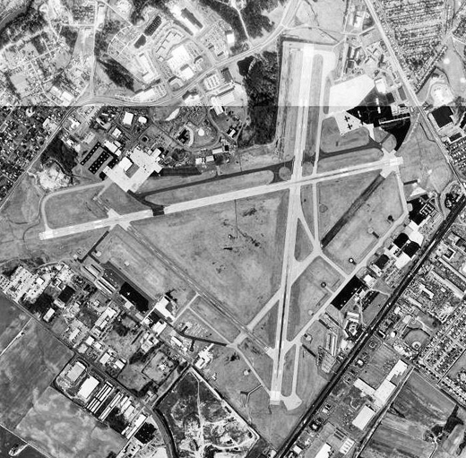 |
| USGS aerial photo as of 16 March 1992 |
| IATA: ILG – ICAO: KILG – FAA LID: ILG |
| Summary |
| Airport type |
Public |
| Owner |
New Castle County, Delaware |
| Operator |
Delaware River and Bay Authority |
| Serves |
Wilmington, Delaware |
| Elevation AMSL |
79 ft / 24 m |
| Coordinates |
39°40′43″N 075°36′24″W / 39.67861°N 75.60667°W / 39.67861; -75.60667 |
| Website |
NewCastleAirportILG.com |
| Runways |
| Direction |
Length |
Surface |
| ft |
m |
| 1/19 |
7,012 |
2,137 |
Asphalt |
| 9/27 |
7,181 |
2,189 |
Asphalt |
| 14/32 |
4,603 |
1,403 |
Asphalt |
| Statistics (2006) |
| Aircraft operations |
136,154 |
| Based aircraft |
282 |
| Source: Federal Aviation Administration |
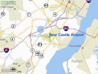
New Castle Airport (IATA: ILG, ICAO: KILG, FAA LID: ILG), also known as the New Castle County Airport, is a public airport located in unincorporated New Castle County, Delaware, United States and four miles (6 km) south of the central business district of the city of Wilmington. History
Military usagePreviously called the Wilmington Airport and the Greater Wilmington Airport, the property became a US Army Air Forces military airfield named New Castle Army Air Base (New Castle AAB) during World War II.
Opened in May 1943, New Castle AAB was assigned to the Air Corps Ferrying Command's 2d Ferrying Group, with the 552d Army Air Forces Base Unit being the host unit in charge of the base and its facilities. The primary mission of the airfield was to facilitate the movement of aircraft overseas for delivery to the British and other Allies. Members of the historic Women Air Service Pilots (WASP) served as test and ferry pilots and towed targets for student gunners. There is a statue today at the airport that honors the women of the WASP that served their country in the time of need. On 30 June 1945, the 1596th AAF Base Unit replaced the 552d AAFBU and the 2d Ferrying Group was replaced by the 2d Foreign Transport Group. The mission of the base was changed to being responsible for overseas air transport of passengers and air cargo. With the general drawdown of the Army Air Forces after the war, New Castle Airport became a joint-use base, with civilian aircraft operating from the airfield as an airport.
After the closure of the Army Air Base, New Castle County Airport then hosted the 166th Air Transport Group of the Delaware National Guard. With the establishment of the US Air Force as an independent service in 1947, the 166th was redesignated as a unit of the Delaware Air National Guard. The unit has been successively known as the 166th Military Airlift Group, 166th Tactical Airlift Group, 166th Airlift Group and is now known as the 166th Airlift Wing (166 AW), operating C-130H Hercules. As an Air National Guard unit, the 166 AW is operationally gained by the Air Mobility Command (AMC).
Civil usage
In the late 1990s, the county leased the debt-stricken airport to the bi-state Delaware River and Bay Authority (DRBA), operators of the Delaware Memorial Bridge, on a thirty year lease with the provision that the DRBA may seek up to two additional thirty year leases.
Since taking over operations of the airport, the DRBA has made the airport profitable, upgraded many aging buildings, and constructed numerous new buildings and facilities on the property.
From 1991 through 1998, again from 2000 to 2006, and since April 2008, the state of Delaware is the only state in the union without any scheduled commercial flights in or out of the state. This is largely due to the small size of the state and the close proximity of large airports in Baltimore, Washington D.C., Philadelphia and Salisbury, MD. Skybus Airlines was the last commercial airline to fly out of New Castle Airport, with flights in 2008. Before Skybus, and Delta in 2006, the previous airline with scheduled flights was Shuttle America, which flew out of New Castle as an independent carrier from the airline's founding in November 1998 until February 2000. They offered service to Hartford, Buffalo, and Norfolk, using the 50-seat Dash 8-300 turboprop aircraft. Shuttle America would eventually discontinue its independent operations and become a commuter affiliate of United Express and Delta Connection. Prior to Shuttle America, the last scheduled service was provided to Parkersburg, West Virginia by USAir Express carrier Crown Airways in 1992-1993. United Airlines also served Wilmington, leaving in 1991.
Overview
The airport has one terminal, which has only served car rental agencies during those times when the airport did not have commercial air service. On June 29, 2006, Delta Air Lines began new services from Atlanta's Hartsfield-Jackson Atlanta International Airport to New Castle Airport, making it the first commercial air service in six years. Delta Connection carrier Atlantic Southeast Airlines operated the service using 50 seat CRJ regional jets, with two daily roundtrip flights. However, Delta Air Lines ended the Wilmington flights on September 6, 2007, leaving Delaware without any commercial air service until March 8, 2008, when Skybus Airlines began new air service from Columbus, Ohio and Greensboro, North Carolina to New Castle Airport. Skybus ceased all operations effective April 4, 2008, once again leaving New Castle Airport without any airline service. As of August 4, 2010, Avis Rent a Car System, LLC, Budget Rent A Car System, Inc., and Cafe Bama are the only tenants in the Main Terminal.
Facilities and aircraft
New Castle Airport covers an area of 1,250 acres (506 ha) which contains three asphalt paved runways: 1/19 measuring 7,012 x 150 ft (2,137 x 46 m), 9/27 measuring 7,181 x 150 ft (2,189 x 46 m), and 14/32 measuring 4,603 x 150 ft (1,403 x 46 m).
For the 12-month period ending December 31, 2006, the airport had 136,154 aircraft operations, an average of 373 per day: 83% general aviation, 12% military, 4% air taxi and 1% scheduled commercial. There are 282 aircraft based at this airport: 59% single engine, 23% jet, 9% multi-engine, 6% helicopter and 3% military.
The above content comes from Wikipedia and is published under free licenses – click here to read more.
Location
& QuickFacts
|
FAA
Information Effective: |
2006-09-28 |
|
Airport
Identifier: |
ILG |
|
Longitude/Latitude: |
075-36-23.5000W/39-40-43.4000N
-75.606528/39.678722 (Estimated) |
|
Elevation: |
79 ft / 24.08 m (Surveyed) |
|
Land: |
1250 acres |
|
From
nearest city: |
4 nautical miles S of Wilmington, DE |
|
Location: |
New Castle County, DE |
|
Magnetic Variation: |
11W (1985) |
Owner
& Manager
|
Ownership: |
Publicly owned |
|
Owner: |
Delaware River & Bay Authority
LEASEE. PROPERTY OWNED BY NEW CASTLE COUNTY 87 READS WAY
NEW CASTLE, DE 19720. TEL
302-395-5990. |
|
Address: |
151 N. Dupont Highway
New Castle, DE 19720-0071 |
|
Phone
number: |
302-328-4632 |
|
Manager: |
Stephen D. Williams |
|
Address: |
151 N. Dupont Highway
New Castle, DE 19720-0071 |
|
Phone number: |
302-325-5576 |
Airport
Operations and Facilities
|
Airport
Use: |
Open to public |
|
Wind
indicator: |
Yes |
|
Segmented
Circle: |
No |
|
Control
Tower: |
Yes |
|
Attendance
Schedule: |
ALL/ALL/ALL |
|
Lighting
Schedule: |
DUSK-DAWN
WHEN ATCT CLSD ACTVT HIRL RYS 01/19; 09/27; MIRL RY 14/32;
TWY LGTS; SSALR RY 01 - CTAF. |
|
Beacon
Color: |
Clear-Green (lighted land airport) |
|
Landing
fee charge: |
Yes
LNDG FEE FOR ALL ACFT OVER 7500 LBS EXCEPT FEDERAL GOVT;
MILITARY. |
|
Sectional
chart: |
Washington |
|
Region: |
AEA - Eastern |
|
Boundary
ARTCC: |
ZDC - Washington |
|
Responsible
ARTCC: |
ZNY - New York |
|
Tie-in
FSS: |
MIV - Millville |
|
FSS
on Airport: |
No |
|
FSS
Phone: |
856-825-8090 |
|
FSS
Toll Free: |
1-800-WX-BRIEF |
|
NOTAMs
Facility: |
ILG (NOTAM-d service avaliable) |
|
Certification
type/date: |
?? 5/1973
PPR 24 HRS FOR ACR OPNS WITH MORE THAN 30 PSGR SEATS CALL
302-247-0204 (DIGITAL PAGER). WHEN ATCT CLSD ANNOUNCE EMERGENCIES
ON CTAF DIRECT TO ARFF STATION. |
|
Federal Agreements: |
NG3YPH |
Airport
Communications
|
CTAF: |
126.000 |
|
Unicom: |
122.950 |
Airport
Services
|
Fuel
available: |
100LLA |
|
Airframe
Repair: |
MAJOR |
|
Power
Plant Repair: |
MAJOR |
|
Bottled
Oxygen: |
HIGH/LOW |
|
Bulk
Oxygen: |
HIGH/LOW |
|
Runway Information
Runway 01/19
|
Dimension: |
7012 x 150 ft / 2137.3 x 45.7 m |
|
Surface: |
ASPH, Fair Condition
RY 14/32 SEVERAL AREAS OF PONDING. |
|
Surface
Treatment: |
Saw-cut or plastic Grooved |
|
Weight
Limit: |
Single wheel: 90000 lbs.
Dual wheel: 140000 lbs.
Dual
tandem wheel: 250000 lbs. |
|
Edge
Lights: |
High
RY 14/32 NON-STANDARD MILITARY ASSAULT LANDING ZONE (ALZ) LIGHTING. |
|
|
Runway 01 |
Runway 19 |
|
Longitude: |
075-36-13.7611W |
075-36-05.8352W |
|
Latitude: |
39-40-09.4450N |
39-41-18.4772N |
|
Elevation: |
75.00 ft |
61.00 ft |
|
Alignment: |
5 |
127 |
|
ILS
Type: |
ILS |
|
|
Traffic
Pattern: |
Left |
Left |
|
Markings: |
Precision instrument, Good Condition |
Non-precision instrument, Good Condition |
|
Crossing
Height: |
0.00
ft |
58.00 ft |
|
VASI: |
|
4-box on left side
RY 19 VASI NON STD DISTANCE FROM RY EDGE. |
|
Visual
Glide Angle: |
0.00� |
3.00� |
|
RVR
Equipment: |
touchdown |
|
|
Approach
lights: |
SSALR |
|
|
Runway
End Identifier: |
|
Yes |
|
Obstruction: |
8 ft road, 500.0 ft from runway, 37:1 slope
to clear |
72 ft trees, 1240.0 ft from runway, 500 ft
left of centerline, 14:1 slope to clear |
|
Runway 09/27
|
Dimension: |
7181 x 150 ft / 2188.8 x 45.7 m |
|
Surface: |
ASPH, Fair Condition
RY 14/32 SEVERAL AREAS OF PONDING. |
|
Surface
Treatment: |
Saw-cut or plastic Grooved |
|
Weight
Limit: |
Single wheel: 90000 lbs.
Dual wheel: 140000 lbs.
Dual
tandem wheel: 250000 lbs. |
|
Edge
Lights: |
High
RY 14/32 NON-STANDARD MILITARY ASSAULT LANDING ZONE (ALZ) LIGHTING. |
|
|
Runway 09 |
Runway 27 |
|
Longitude: |
075-37-12.5926W |
075-35-42.8413W |
|
Latitude: |
39-40-41.2892N |
39-40-56.3636N |
|
Elevation: |
79.00 ft |
71.00 ft |
|
Alignment: |
78 |
127 |
|
ILS
Type: |
MLS |
|
|
Traffic
Pattern: |
Left |
Left |
|
Markings: |
Precision instrument, Good Condition
RWY 09/27 MILITARY PAINT MKGS ON RWY. |
Non-precision instrument, Good Condition |
|
Crossing
Height: |
55.00 ft |
51.00 ft |
|
VASI: |
4-light PAPI on left side |
4-box on left side |
|
Visual
Glide Angle: |
3.00� |
3.00� |
|
Obstruction: |
49 ft trees, 1125.0 ft from runway, 600 ft
left of centerline, 18:1 slope to clear
+5' GND AT AER 480' R. |
64 ft trees, 1000.0 ft from runway, 75 ft right
of centerline, 12:1 slope to clear |
|
Runway 14/32
|
Dimension: |
4603 x 150 ft / 1403.0 x 45.7 m |
|
Surface: |
ASPH, Good Condition
RY 14/32 SEVERAL AREAS OF PONDING. |
|
Weight
Limit: |
Single wheel: 50000 lbs.
Dual wheel: 60000 lbs. |
|
Edge
Lights: |
Medium
RY 14/32 NON-STANDARD MILITARY ASSAULT LANDING ZONE (ALZ) LIGHTING. |
|
|
Runway 14 |
Runway 32 |
|
Longitude: |
075-37-00.0973W |
075-36-15.5617W |
|
Latitude: |
39-40-48.9076N |
39-40-19.1511N |
|
Elevation: |
75.00 ft |
74.00 ft |
|
Alignment: |
127 |
127 |
|
Traffic
Pattern: |
Left |
Left |
|
Markings: |
Basic, Good Condition |
Basic, Good Condition |
|
Crossing
Height: |
0.00
ft |
27.00 ft |
|
VASI: |
|
4-box on left side |
|
Visual
Glide Angle: |
0.00� |
3.00� |
|
Approach
lights: |
|
NSTD |
|
Obstruction: |
43 ft trees, 720.0 ft from runway, 200 ft left
of centerline, 12:1 slope to clear |
, 50:1 slope to clear |
|
Radio Navigation
Aids
|
ID |
Type |
Name |
Ch |
Freq |
Var |
Dist |
|
APG |
NDB |
Aberdeen |
|
349.00 |
11W |
24.7 nm |
|
RNB |
NDB |
Rainbow |
|
363.00 |
11W |
26.9 nm |
|
ING |
NDB |
Ambler |
|
275.00 |
11W |
30.7 nm |
|
NXX |
NDB |
Willow Grove |
|
388.00 |
12W |
37.3 nm |
|
MTN |
NDB |
Martin |
|
342.00 |
11W |
42.5 nm |
|
DYL |
NDB |
Doylestown |
|
237.00 |
10W |
45.4 nm |
|
UKT |
NDB |
Quakertown |
|
208.00 |
12W |
47.0 nm |
|
DOV |
TACAN |
Dover |
037X |
|
09W |
33.5 nm |
|
NXX |
TACAN |
Willow Grove |
061X |
|
10W |
37.6 nm |
|
MTN |
TACAN |
Martin |
068X |
|
11W |
42.8 nm |
|
PNE |
VOR |
North Philadelphia |
|
112.00 |
10W |
36.7 nm |
|
PPM |
VOR/DME |
Phillips |
021X |
108.40 |
09W |
29.1 nm |
|
CKZ |
VOR/DME |
Pennridge |
025Y |
108.85 |
12W |
45.2 nm |
|
ARD |
VOR/DME |
Yardley |
019X |
108.20 |
10W |
47.2 nm |
|
OOD |
VORTAC |
Woodstown |
075X |
112.80 |
10W |
14.3 nm |
|
MXE |
VORTAC |
Modena |
079X |
113.20 |
09W |
14.7 nm |
|
ENO |
VORTAC |
Smyrna |
051X |
111.40 |
09W |
27.2 nm |
|
VCN |
VORTAC |
Cedar Lake |
099X |
115.20 |
10W |
30.8 nm |
|
PTW |
VORTAC |
Pottstown |
112X |
116.50 |
09W |
32.7 nm |
|
LRP |
VORTAC |
Lancaster |
120X |
117.30 |
09W |
41.2 nm |
|
ACY |
VORTAC |
Atlantic City |
023X |
108.60 |
10W |
49.6 nm |
|
PHL |
VOT |
Philadelphia Intl |
|
109.80 |
|
20.3 nm |
Remarks
- RY
14/32 CLSD TO LARGE AIR CARRIER AIRCRAFT OPERS WITH MORE THAN 30 PSGR
SEATS.
- WHEN
ATCT CLSD, PILOTS MUST ANNOUNCE INTENTIONS OVER CTAF BEFORE LDGS; TKOFS
OR GND TRAVEL ON RYS & TWYS.
- PVT
GND VEHICLES CROSS TWY A BTN TWYS A4 & C.
- TWY
"K1" CLOSED INDEFINITELY.
- BIRDS
ON & INVOF ARPT.
- RWY
09/27 NO TGL FOR TURBO JET 2300-0700.
- TWY
'G' SECTION BTN TWYS 'H' & 'J' LMTD TO ACFT WITH WINGSPAN OF 79
FT OR LESS.
- WHEN
TERMINAL BLDG CLSD 2300-0600 CTC ARPT SAFETY DEPARTMENT ON 126.0 OR
302-247-0204 (DIGITAL PAGER).
- TWY
'G' SECTION BTN TWYS 'H' & 'D' LMTD TO ACFT WITH WINGSPAN OF 49
FT OR LESS.
Based Aircraft
|
Aircraft
based on field: |
282 |
|
Single
Engine Airplanes: |
167 |
|
Multi
Engine Airplanes: |
24 |
|
Jet Engine
Airplanes: |
66 |
|
Helicopters: |
16 |
|
Military: |
9 |
Operational Statistics
|
Aircraft
Operations: |
360/Day |
|
Air Carrier: |
0.1% |
|
Air Taxi: |
2.9% |
|
General
Aviation Local: |
53.4% |
|
General
Aviation Itinerant: |
37.5% |
|
Military: |
6.1% |
New Castle Airport
Address:
New Castle County, DE
Tel:
302-328-4632,
302-325-5576
Images
and information placed above are from
http://www.airport-data.com/airport/ILG/
We
thank them for the data!
| General
Info |
| Country |
United
States |
| State |
DELAWARE
|
| FAA ID |
ILG
|
| Latitude |
39-40-43.400N
|
| Longitude |
075-36-23.500W
|
| Elevation |
79 feet
|
| Near City |
WILMINGTON
|
We don't guarantee the information is fresh and accurate. The data may
be wrong or outdated.
For more up-to-date information please refer to other sources.
|
|


