 |
|
| Laurel Airport |
| IATA: none – ICAO: none – FAA LID: N06 |
| Summary |
| Airport type |
Public |
| Owner |
Dest Inc. |
| Serves |
Laurel, Delaware |
| Elevation AMSL |
30 ft / 9 m |
| Coordinates |
38°32′32″N 075°35′40″W / 38.54222°N 75.59444°W / 38.54222; -75.59444 |
| Runways |
| Direction |
Length |
Surface |
| ft |
m |
| 15/33 |
3,175 |
968 |
Turf |
| Statistics (2005) |
| Aircraft operations |
7,750 |
| Source: Federal Aviation Administration |
Laurel Airport (FAA LID: N06) is a public-use airport located one nautical mile (2 km) southwest of the central business district of Laurel, a city in Sussex County, Delaware, United States. It is privately owned by Dest Inc.
It is currently referred to as Laurel Airport by both the Federal Aviation Administration and Delaware Department of Transportation. However, it had been renamed Western Sussex Airport-Booth Field by a prior owner known as Aerospace House Inc.
Facilities and aircraft
Laurel Airport covers an area of 88 acres (36 ha) at an elevation of 30 feet (9 m) above mean sea level. It has one runway designated 15/33, with a turf surface measuring 3,175 by 270 ft (968 x 82 m). For the 12-month period ending July 26, 2005, the airport had 7,750 general aviation aircraft operations, an average of 21 per day.
The above content comes from Wikipedia and is published under free licenses – click here to read more.
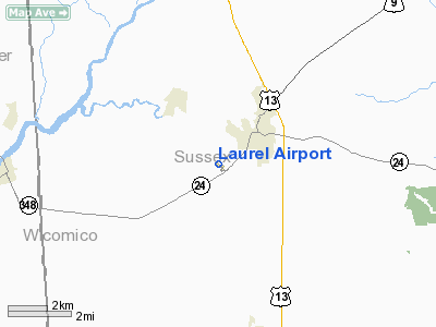
Location
& QuickFacts
|
FAA
Information Effective: |
2006-09-28 |
|
Airport
Identifier: |
N06 |
|
Longitude/Latitude: |
075-35-39.6660W/38-32-31.8640N
-75.594352/38.542184 (Estimated) |
|
Elevation: |
30 ft / 9.14 m (Estimated) |
|
Land: |
88 acres |
|
From
nearest city: |
1 nautical miles SW of Laurel, DE |
|
Location: |
Sussex County, DE |
|
Magnetic Variation: |
12W (2000) |
Owner
& Manager
|
Ownership: |
Privately owned |
|
Owner: |
Diane Boyce |
|
Address: |
102 Stewart St
Dover, DE 19901 |
|
Phone
number: |
302-697-6020 |
|
Manager: |
Rob Collins |
|
Address: |
P.o. Box 11
Laurel, DE 19956 |
|
Phone number: |
302-875-7030 |
Airport
Operations and Facilities
|
Airport
Use: |
Open to public |
|
Wind
indicator: |
Yes |
|
Segmented
Circle: |
No |
|
Control
Tower: |
No |
|
Attendance
Schedule: |
ALL/ALL/0800-DUSK |
|
Lighting
Schedule: |
RDO-CTL
ACTVT LIRL RY 15/33 & REIL RY 33 & ROTG BCN - CTAF. |
|
Beacon
Color: |
Clear-Green (lighted land airport) |
|
Landing
fee charge: |
No |
|
Sectional
chart: |
Washington |
|
Region: |
AEA - Eastern |
|
Boundary
ARTCC: |
ZDC - Washington |
|
Tie-in
FSS: |
MIV - Millville |
|
FSS
on Airport: |
No |
|
FSS
Phone: |
856-825-8090 |
|
FSS
Toll Free: |
1-800-WX-BRIEF |
|
NOTAMs
Facility: |
MIV (NOTAM-d service avaliable) |
Airport
Communications
|
CTAF: |
122.800 |
|
Unicom: |
122.800 |
Airport
Services
|
Airframe
Repair: |
MAJOR |
|
Power
Plant Repair: |
MAJOR |
|
Bottled
Oxygen: |
NONE |
|
Bulk
Oxygen: |
NONE |
|
Runway Information
Runway 15/33
|
Dimension: |
3175 x 270 ft / 967.7 x 82.3 m |
|
Surface: |
TURF, Good Condition |
|
Edge
Lights: |
Low
SOUTH 2100 FT LGTD; NORTH 1075 FT UNLGTD. |
|
|
Runway 15 |
Runway 33 |
|
Longitude: |
075-35-52.4820W |
075-35-24.9100W |
|
Latitude: |
38-32-43.8410N |
38-32-21.1030N |
|
Elevation: |
29.00 ft |
30.00 ft |
|
Alignment: |
127 |
127 |
|
Traffic
Pattern: |
Left |
Left |
|
Displaced
threshold: |
0.00
ft |
270.00 ft |
|
Runway
End Identifier: |
No |
Yes |
|
Obstruction: |
54 ft trees, 600.0 ft from runway, 40 ft right
of centerline, 12:1 slope to clear |
67 ft road, 30.0 ft from runway, 2:1 slope
to clear
RY 33 APCH SLOPE 20:1 TO DSPLCD THLD. |
|
Radio Navigation
Aids
|
ID |
Type |
Name |
Ch |
Freq |
Var |
Dist |
|
CGE |
NDB |
Cambridge |
|
355.00 |
10W |
20.6 nm |
|
OX |
NDB |
Landy |
|
407.00 |
12W |
21.6 nm |
|
ESN |
NDB |
Easton |
|
212.00 |
10W |
27.3 nm |
|
NHK |
NDB |
Patuxent |
|
400.00 |
10W |
41.1 nm |
|
DOV |
TACAN |
Dover |
037X |
|
09W |
36.0 nm |
|
ATR |
VOR/DME |
Waterloo |
073X |
112.60 |
09W |
24.1 nm |
|
SBY |
VORTAC |
Salisbury |
049X |
111.20 |
12W |
12.5 nm |
|
SWL |
VORTAC |
Snow Hill |
071X |
112.40 |
08W |
29.8 nm |
|
PXT |
VORTAC |
Patuxent |
123X |
117.60 |
10W |
40.9 nm |
|
ENO |
VORTAC |
Smyrna |
051X |
111.40 |
09W |
41.6 nm |
|
SIE |
VORTAC |
Sea Isle |
095X |
114.80 |
09W |
49.9 nm |
Remarks
- SIGNIFICANT
SKY-DIVING OPERATION SEASONAL TO ALL BUT WINTER MONTHS.
- EXISTED
PRIOR TO 1959.
Based Aircraft
|
Aircraft
based on field: |
14 |
|
Single
Engine Airplanes: |
13 |
|
Multi
Engine Airplanes: |
1 |
Operational Statistics
|
Aircraft
Operations: |
150/Week |
|
General
Aviation Local: |
90.3% |
|
General
Aviation Itinerant: |
9.7% |
Laurel Airport
Address:
Sussex County, DE
Tel:
302-697-6020,
302-875-7030
Images
and information placed above are from
http://www.airport-data.com/airport/N06/
We
thank them for the data!
| General
Info |
| Country |
United
States |
| State |
DELAWARE
|
| FAA ID |
N06
|
| Latitude |
38-32-31.864N
|
| Longitude |
075-35-39.666W
|
| Elevation |
30 feet
|
| Near City |
LAUREL
|
We don't guarantee the information is fresh and accurate. The data may
be wrong or outdated.
For more up-to-date information please refer to other sources.
|
|


