 |
|
| Jenkins Airport |
| IATA: none – ICAO: none – FAA LID: 15N |
| Summary |
| Airport type |
Public |
| Owner |
Joe C. Jenkins |
| Serves |
Wyoming, Delaware |
| Elevation AMSL |
53 ft / 16 m |
| Coordinates |
39°07′10″N 075°35′02″W / 39.11944°N 75.58389°W / 39.11944; -75.58389 |
| Runways |
| Direction |
Length |
Surface |
| ft |
m |
| 12/30 |
2,035 |
620 |
Turf |
| 18/36 |
2,842 |
866 |
Turf |
| Statistics (2005) |
| Aircraft operations |
2,500 |
| Source: Federal Aviation Administration |
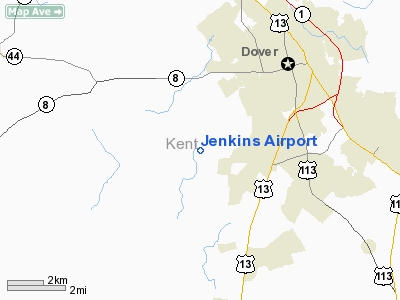
Jenkins Airport (FAA LID: 15N) is a public use airport located one nautical mile (2 km) west of the central business district of Wyoming, a town in Kent County, Delaware, United States. It is privately owned by Joe C. Jenkins.
Facilities and aircraft
Jenkins Airport covers an area of 60 acres (24 ha) at an elevation of 53 feet (16 m) above mean sea level. It has two runways, both with turf surfaces: 12/30 is 2,035 by 70 feet (620 x 21 m) and 18/36 is 2,842 by 70 feet (866 x 21 m). For the 12-month period ending July 24, 2005, the airport had 2,500 general aviation aircraft operations, an average of 208 per month.
The above content comes from Wikipedia and is published under free licenses – click here to read more.
Location
& QuickFacts
|
FAA
Information Effective: |
2006-09-28 |
|
Airport
Identifier: |
15N |
|
Longitude/Latitude: |
075-35-01.7330W/39-07-10.4040N
-75.583815/39.119557 (Estimated) |
|
Elevation: |
53 ft / 16.15 m (Estimated) |
|
Land: |
60 acres |
|
From
nearest city: |
1 nautical miles W of Wyoming, DE |
|
Location: |
Kent County, DE |
|
Magnetic Variation: |
11W (1985) |
Owner
& Manager
|
Ownership: |
Privately owned |
|
Owner: |
Joe C. Jenkins |
|
Address: |
9935 Westville Rd
Wyoming, DE 19934 |
|
Phone number: |
302-697-7743 |
|
Manager: |
Joe C. Jenkins |
|
Address: |
9935 Westville Rd
Wyoming, DE 19934 |
|
Phone number: |
302-697-7743 |
Airport
Operations and Facilities
|
Airport
Use: |
Open to public |
|
Wind
indicator: |
Yes |
|
Segmented
Circle: |
No |
|
Control
Tower: |
No |
|
Attendance
Schedule: |
ALL/ALL/ALL |
|
Lighting
Schedule: |
RDO-CTL
ACTVT LIRL RY 18/36 & ROTG BCN - 122.7. |
|
Beacon
Color: |
Clear-Green (lighted land airport) |
|
Landing
fee charge: |
No |
|
Sectional
chart: |
Washington |
|
Region: |
AEA - Eastern |
|
Boundary
ARTCC: |
ZDC - Washington |
|
Tie-in
FSS: |
MIV - Millville |
|
FSS
on Airport: |
No |
|
FSS
Phone: |
856-825-8090 |
|
FSS
Toll Free: |
1-800-WX-BRIEF |
|
NOTAMs
Facility: |
MIV (NOTAM-d service avaliable) |
Airport
Communications
|
CTAF: |
122.800 |
|
Unicom: |
122.800 |
Airport
Services
|
Airframe
Repair: |
MAJOR |
|
Power
Plant Repair: |
MAJOR |
|
Bottled
Oxygen: |
NONE |
|
Bulk
Oxygen: |
NONE |
|
Runway Information
Runway 12/30
|
Dimension: |
2035 x 70 ft / 620.3 x 21.3 m |
|
Surface: |
TURF, Good Condition |
|
|
Runway 12 |
Runway 30 |
|
Traffic
Pattern: |
Left |
Left |
|
Obstruction: |
, 50:1 slope to clear |
15 ft road, 100.0 ft from runway, 6:1 slope
to clear |
|
Runway 18/36
|
Dimension: |
2842 x 70 ft / 866.2 x 21.3 m |
|
Surface: |
TURF, Good Condition |
|
Edge
Lights: |
Low |
|
|
Runway 18 |
Runway 36 |
|
Traffic
Pattern: |
Left |
Left |
|
Displaced
threshold: |
0.00
ft |
225.00 ft |
|
Obstruction: |
60 ft trees, 85.0 ft from runway, 130 ft right
of centerline, 1:1 slope to clear |
74 ft road, 400.0 ft from runway, 5:1 slope
to clear
RY 36 APCH RATIO 20:1 TO DSPLCD THLD. |
|
Radio Navigation
Aids
|
ID |
Type |
Name |
Ch |
Freq |
Var |
Dist |
|
RNB |
NDB |
Rainbow |
|
363.00 |
11W |
27.5 nm |
|
ESN |
NDB |
Easton |
|
212.00 |
10W |
29.5 nm |
|
APG |
NDB |
Aberdeen |
|
349.00 |
11W |
34.8 nm |
|
MTN |
NDB |
Martin |
|
342.00 |
11W |
38.6 nm |
|
CGE |
NDB |
Cambridge |
|
355.00 |
10W |
40.8 nm |
|
OX |
NDB |
Landy |
|
407.00 |
12W |
49.0 nm |
|
IUB |
NDB |
Institute |
|
404.00 |
08W |
49.5 nm |
|
DOV |
TACAN |
Dover |
037X |
|
09W |
5.5 nm |
|
MTN |
TACAN |
Martin |
068X |
|
11W |
40.6 nm |
|
ATR |
VOR/DME |
Waterloo |
073X |
112.60 |
09W |
25.5 nm |
|
PPM |
VOR/DME |
Phillips |
021X |
108.40 |
09W |
34.4 nm |
|
ENO |
VORTAC |
Smyrna |
051X |
111.40 |
09W |
7.4 nm |
|
DQO |
VORTAC |
Dupont |
087X |
114.00 |
10W |
33.6 nm |
|
OOD |
VORTAC |
Woodstown |
075X |
112.80 |
10W |
33.7 nm |
|
SIE |
VORTAC |
Sea Isle |
095X |
114.80 |
09W |
36.6 nm |
|
VCN |
VORTAC |
Cedar Lake |
099X |
115.20 |
10W |
38.1 nm |
|
SBY |
VORTAC |
Salisbury |
049X |
111.20 |
12W |
46.7 nm |
|
MXE |
VORTAC |
Modena |
079X |
113.20 |
09W |
48.2 nm |
|
PHL |
VOT |
Philadelphia Intl |
|
109.80 |
|
47.8 nm |
Remarks
Based Aircraft
|
Aircraft
based on field: |
20 |
|
Single
Engine Airplanes: |
18 |
|
Multi
Engine Airplanes: |
1 |
|
Gliders: |
1 |
Operational Statistics
|
Aircraft
Operations: |
49/Week |
|
General
Aviation Local: |
40.0% |
|
General
Aviation Itinerant: |
60.0% |
Jenkins Airport
Address:
Kent County, DE
Tel:
302-697-7743
Images
and information placed above are from
http://www.airport-data.com/airport/15N/
We
thank them for the data!
| General
Info |
| Country |
United
States |
| State |
DELAWARE
|
| FAA ID |
15N
|
| Latitude |
39-07-10.404N
|
| Longitude |
075-35-01.733W
|
| Elevation |
53 feet
|
| Near City |
WYOMING
|
We don't guarantee the information is fresh and accurate. The data may
be wrong or outdated.
For more up-to-date information please refer to other sources.
|
|


