 |
|
Coordinates: 39°13′06″N 075°35′47″W / 39.21833°N 75.59639°W / 39.21833; -75.59639
| Delaware Airpark |
| IATA: none – ICAO: none – FAA LID: 33N |
| Summary |
| Airport type |
Public |
| Owner |
Delaware River and Bay Authority |
| Serves |
Dover, Delaware |
| Location |
Cheswold, Delaware |
| Elevation AMSL |
56 ft / 17 m |
| Website |
www.drbaairports.com/airpark/ |
| Runways |
| Direction |
Length |
Surface |
| ft |
m |
| 9/27 |
3,582 |
1,092 |
Asphalt |
| Statistics (2006) |
| Aircraft operations |
36,000 |
| Based aircraft |
46 |
| Source: Federal Aviation Administration |
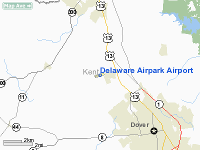
Delaware Airpark (FAA LID: 33N) is a public airport serves the Dover area and is located one mile (1.6 km) west of the central business district of Cheswold, a town in Kent County, Delaware, United States. It is owned by the Delaware River and Bay Authority.
33N is home to Delaware State University's flight training program, providing its students with year-round flying capability. Twice a year, Dover plays host to NASCAR racing events at the Dover International Speedway. Many race teams, drivers and fans use Delaware Airpark because of its proximity to the track.
Facilities and aircraft
Delaware Airpark covers an area of 65 acres (26 ha) which contains one asphalt paved runway (9/27) measuring 3,582 x 60 ft (1,092 x 18 m). For the 12-month period ending April 6, 2006, the airport had 36,000 aircraft operations, an average of 98 per day, 100% of which were general aviation. There are 46 aircraft based at this airport: 93% single engine, 4% multi-engine and 2% helicopters.
The above content comes from Wikipedia and is published under free licenses – click here to read more.
Location
& QuickFacts
|
FAA
Information Effective: |
2006-09-28 |
|
Airport
Identifier: |
33N |
|
Longitude/Latitude: |
075-35-47.1360W/39-13-06.1520N
-75.596427/39.218376 (Estimated) |
|
Elevation: |
56 ft / 17.07 m (Surveyed) |
|
Land: |
65 acres |
|
From
nearest city: |
1 nautical miles W of Dover/cheswold, DE |
|
Location: |
Kent County, DE |
|
Magnetic Variation: |
12W (1995) |
Owner
& Manager
|
Ownership: |
Publicly owned |
|
Owner: |
Delaware River & Bay Authority
LEASEE. PROPERTY OWNED BY DELAWARE DEPARTMENT OF TRANSPORTATION,
P.O. BOX 778, DOVER, DE 19903. 302-760-2149 |
|
Address: |
P.o. Box 71
New Castle, DE 19720 |
|
Phone
number: |
302-571-6474 |
|
Manager: |
Steven D. Williams |
|
Address: |
151 N. Dupont Highway
New Castle, DE 19720 |
|
Phone number: |
302-325-5576
OR PAGE 302-247-6857/3119. |
Airport
Operations and Facilities
|
Airport
Use: |
Open to public |
|
Wind
indicator: |
Yes |
|
Segmented
Circle: |
No |
|
Control
Tower: |
No |
|
Attendance
Schedule: |
ALL/ALL/ 0800-1600 |
|
Lighting
Schedule: |
RDO-CTL
ACTVT MIRL RY 09/27 & ROTG BCN - CTAF . |
|
Beacon
Color: |
Clear-Green (lighted land airport) |
|
Sectional
chart: |
Washington |
|
Region: |
AEA - Eastern |
|
Traffic
Pattern Alt: |
856 ft |
|
Boundary
ARTCC: |
ZDC - Washington |
|
Tie-in
FSS: |
MIV - Millville |
|
FSS
on Airport: |
No |
|
FSS
Phone: |
856-825-8090 |
|
FSS
Toll Free: |
1-800-WX-BRIEF |
|
NOTAMs
Facility: |
MIV (NOTAM-d service avaliable) |
|
Federal Agreements: |
N |
Airport
Communications
|
CTAF: |
123.000 |
|
Unicom: |
123.000 |
Airport
Services
|
Fuel
available: |
100LL
24 HR SELF-SERVICE CREDIT CARD FUEL AVBL. |
|
Airframe
Repair: |
NONE |
|
Power
Plant Repair: |
NONE |
|
Bottled
Oxygen: |
NONE |
|
Bulk
Oxygen: |
NONE |
|
Runway Information
Runway 09/27
|
Dimension: |
3582 x 60 ft / 1091.8 x 18.3 m |
|
Surface: |
ASPH, Good Condition |
|
Weight
Limit: |
Single wheel: 13000 lbs.
Dual wheel: 18000 lbs. |
|
Edge
Lights: |
Medium |
|
|
Runway 09 |
Runway 27 |
|
Longitude: |
075-36-09.7500W |
075-35-26.1400W |
|
Latitude: |
39-13-00.9400N |
39-13-11.0800N |
|
Elevation: |
54.00 ft |
44.00 ft |
|
Alignment: |
73 |
127 |
|
Traffic
Pattern: |
Left |
Left |
|
Markings: |
Nonstandard, Good Condition
NO THRESHOLD PAVEMENT STRIPES RY 09, ONLY NUMERALS AND CENTERLINE. |
Non-precision instrument, Good Condition |
|
Displaced
threshold: |
1005.00 ft
MARKED BY WHITE BOARDS FOR DAYTIME OPERATIONS. |
350.00 ft |
|
Runway
End Identifier: |
No |
No |
|
Obstruction: |
53 ft trees, 260.0 ft from runway, 160 ft right
of centerline, 1:1 slope to clear
RY 09 APCH SLOPE 17:1 DUE TO 40 FT TREES 690 FT FROM DSPLCD
THLD. |
54 ft ant, 955.0 ft from runway, 13:1 slope
to clear
RY 27 APCH SLOPE 1:1 DUE TO 68 FT TREES 135 FT FROM DSPLCD
THLD. |
|
Decleard
distances: |
Take off run available 3582.00 ft
Take off distance available 3582.00 ft
Actual stop distance available 3232.00 ft
Landing distance available 2227.00 ft |
Take off run available 3582.00 ft
Take off distance available 3582.00 ft
Actual stop distance available 3342.00 ft
Landing distance available 2992.00 ft |
|
Radio Navigation
Aids
|
ID |
Type |
Name |
Ch |
Freq |
Var |
Dist |
|
RNB |
NDB |
Rainbow |
|
363.00 |
11W |
24.6 nm |
|
APG |
NDB |
Aberdeen |
|
349.00 |
11W |
30.4 nm |
|
ESN |
NDB |
Easton |
|
212.00 |
10W |
33.3 nm |
|
MTN |
NDB |
Martin |
|
342.00 |
11W |
36.8 nm |
|
CGE |
NDB |
Cambridge |
|
355.00 |
10W |
45.7 nm |
|
IUB |
NDB |
Institute |
|
404.00 |
08W |
48.1 nm |
|
DOV |
TACAN |
Dover |
037X |
|
09W |
7.9 nm |
|
MTN |
TACAN |
Martin |
068X |
|
11W |
38.5 nm |
|
ATR |
VOR/DME |
Waterloo |
073X |
112.60 |
09W |
30.4 nm |
|
PPM |
VOR/DME |
Phillips |
021X |
108.40 |
09W |
30.6 nm |
|
ENO |
VORTAC |
Smyrna |
051X |
111.40 |
09W |
3.8 nm |
|
DQO |
VORTAC |
Dupont |
087X |
114.00 |
10W |
27.6 nm |
|
OOD |
VORTAC |
Woodstown |
075X |
112.80 |
10W |
28.6 nm |
|
VCN |
VORTAC |
Cedar Lake |
099X |
115.20 |
10W |
35.0 nm |
|
SIE |
VORTAC |
Sea Isle |
095X |
114.80 |
09W |
37.8 nm |
|
MXE |
VORTAC |
Modena |
079X |
113.20 |
09W |
42.2 nm |
|
ACY |
VORTAC |
Atlantic City |
023X |
108.60 |
10W |
49.5 nm |
|
BAL |
VORTAC |
Baltimore |
098X |
115.10 |
11W |
49.7 nm |
|
PHL |
VOT |
Philadelphia Intl |
|
109.80 |
|
42.4 nm |
Remarks
- IF
YOUR ACFT CANNOT OPR AT THIS ARPT DUE TO SIZE OR LACK OF FACILITIES,
AN ALTERNATIVE IS THE DOVER CIVIL AIR TERMINAL LCTD AT DOVER AFB.
TO USE, 72 HR
PPR CALL 302-735-5519 OR PAGE 302-247-6857/3119.
- DEER
AND BIRDS ON AND INVOF ARPT.
- MOWING
OPS CONDUCTED 0600-1300 APR-OCT.
- UNCONTROLLED
VEHICULAR TRAFFIC CROSSES CENTER FIELD.
- APPROACH
END OF RWY 09 OBSCURED DUE TO TREES.
Based Aircraft
|
Aircraft
based on field: |
46 |
|
Single
Engine Airplanes: |
43 |
|
Multi
Engine Airplanes: |
2 |
|
Helicopters: |
1 |
Operational Statistics
|
Aircraft
Operations: |
99/Day |
|
General
Aviation Local: |
83.3% |
|
General
Aviation Itinerant: |
16.7% |
Delaware Airpark Airport
Address:
Kent County, DE
Tel:
302-571-6474,
302-325-5576
Images
and information placed above are from
http://www.airport-data.com/airport/33N/
We
thank them for the data!
| General
Info |
| Country |
United
States |
| State |
DELAWARE
|
| FAA ID |
33N
|
| Latitude |
39-13-06.152N
|
| Longitude |
075-35-47.136W
|
| Elevation |
56 feet
|
| Near City |
DOVER/CHESWOLD
|
We don't guarantee the information is fresh and accurate. The data may
be wrong or outdated.
For more up-to-date information please refer to other sources.
|
|


