 |
|
| Chorman Airport |
| IATA: none – ICAO: none – FAA LID: D74 |
| Summary |
| Airport type |
Public |
| Owner |
Allen Chorman |
| Serves |
Farmington, Delaware |
| Elevation AMSL |
66 ft / 20 m |
| Coordinates |
38°50′58″N 075°36′46″W / 38.84944°N 75.61278°W / 38.84944; -75.61278 |
| Runways |
| Direction |
Length |
Surface |
| ft |
m |
| 16/34 |
3,588 |
1,094 |
Asphalt |
| Statistics (2009) |
| Aircraft operations |
14,600 |
| Source: Federal Aviation Administration |
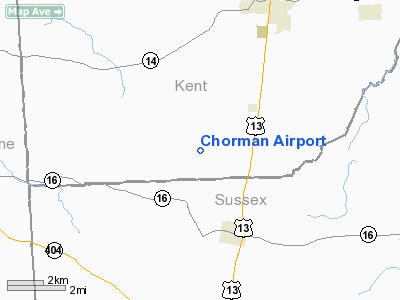
Chorman Airport (FAA LID: D74) is a public use airport located two nautical miles (4 km) southwest of the central business district of Farmington, in Kent County, Delaware, United States. It is privately owned by Allen Chorman.
Facilities and aircraft
Chorman Airport covers an area of 134 acres (54 ha) at an elevation of 66 feet (20 m) above mean sea level. It has one asphalt paved runway designated 16/34 which measures 3,588 by 37 feet (1,094 x 11 m). For the 12-month period ending March 10, 2009, the airport had 14,600 general aviation aircraft operations, an average of 40 per day.
The above content comes from Wikipedia and is published under free licenses – click here to read more.
Location
& QuickFacts
|
FAA
Information Effective: |
2006-09-28 |
|
Airport
Identifier: |
D74 |
|
Longitude/Latitude: |
075-36-44.7370W/38-50-54.4080N
-75.612427/38.848447 (Estimated) |
|
Elevation: |
66 ft / 20.12 m (Surveyed) |
|
Land: |
134 acres |
|
From
nearest city: |
2 nautical miles SW of Farmington, DE |
|
Location: |
Kent County, DE |
|
Magnetic Variation: |
11W (1990) |
Owner
& Manager
|
Ownership: |
Privately owned |
|
Owner: |
Allen Chorman |
|
Address: |
64 East Mill Run
Milton, DE 19968 |
|
Phone number: |
302-645-9225 |
|
Manager: |
Allen Chorman |
|
Address: |
2057 9 Ft Rd
Greenwood, DE 11952 |
|
Phone number: |
302-349-5055 |
Airport
Operations and Facilities
|
Airport
Use: |
Open to public |
|
Wind
indicator: |
Yes |
|
Segmented
Circle: |
No |
|
Control
Tower: |
No |
|
Attendance
Schedule: |
ALL/MON-FRI/0830-DUSK |
|
Lighting
Schedule: |
PHONE REQ
FOR LIRL RY 16/34 & ROTG BCN CALL 302-349-5055 OR 645-9225. |
|
Beacon
Color: |
Clear-Green (lighted land airport) |
|
Sectional
chart: |
Washington |
|
Region: |
AEA - Eastern |
|
Boundary
ARTCC: |
ZDC - Washington |
|
Tie-in
FSS: |
MIV - Millville |
|
FSS
on Airport: |
No |
|
FSS
Phone: |
856-825-8090 |
|
FSS
Toll Free: |
1-800-WX-BRIEF |
|
NOTAMs
Facility: |
MIV (NOTAM-d service avaliable) |
Airport
Communications
Airport
Services
|
Airframe
Repair: |
MAJOR |
|
Power
Plant Repair: |
MAJOR |
|
Runway Information
Runway 16/34
|
Dimension: |
3588 x 37 ft / 1093.6 x 11.3 m |
|
Surface: |
ASPH, Fair Condition |
|
Edge
Lights: |
Low |
|
|
Runway 16 |
Runway 34 |
|
Traffic
Pattern: |
Left |
Left |
|
Markings: |
Numbers only, Fair Condition |
Numbers only, Fair Condition |
|
VASI: |
tri-color on left side |
tri-color on left side |
|
Obstruction: |
62 ft trees, 1485.0 ft from runway, 20:1 slope
to clear |
12 ft sign, 235.0 ft from runway, 36 ft right
of centerline, 2:1 slope to clear |
|
Radio Navigation
Aids
|
ID |
Type |
Name |
Ch |
Freq |
Var |
Dist |
|
ESN |
NDB |
Easton |
|
212.00 |
10W |
21.6 nm |
|
CGE |
NDB |
Cambridge |
|
355.00 |
10W |
27.1 nm |
|
OX |
NDB |
Landy |
|
407.00 |
12W |
35.1 nm |
|
RNB |
NDB |
Rainbow |
|
363.00 |
11W |
40.8 nm |
|
MTN |
NDB |
Martin |
|
342.00 |
11W |
44.9 nm |
|
APG |
NDB |
Aberdeen |
|
349.00 |
11W |
47.3 nm |
|
DOV |
TACAN |
Dover |
037X |
|
09W |
18.4 nm |
|
MTN |
TACAN |
Martin |
068X |
|
11W |
47.2 nm |
|
ATR |
VOR/DME |
Waterloo |
073X |
112.60 |
09W |
18.9 nm |
|
PPM |
VOR/DME |
Phillips |
021X |
108.40 |
09W |
45.4 nm |
|
ENO |
VORTAC |
Smyrna |
051X |
111.40 |
09W |
23.5 nm |
|
SBY |
VORTAC |
Salisbury |
049X |
111.20 |
12W |
30.6 nm |
|
SIE |
VORTAC |
Sea Isle |
095X |
114.80 |
09W |
40.8 nm |
|
SWL |
VORTAC |
Snow Hill |
071X |
112.40 |
08W |
48.1 nm |
|
OOD |
VORTAC |
Woodstown |
075X |
112.80 |
10W |
49.5 nm |
|
DQO |
VORTAC |
Dupont |
087X |
114.00 |
10W |
49.9 nm |
Remarks
- AGRICULTURE
SPRAYING ACTIVITY ON & INVOF ARPT.
- LOADING
PAD ADJACENT TO EAST SIDE RY 34.
- PRVDD
VFR, PRIVATE USE, THAT 41 FT CEDAR TREE S OF ARPT LOWERED TO GIVE 20:1
APCH SFC; RY END BE DSPLCD 90 FT DUE TO PUBLIC ROAD S OF RY; WIDTH OF
PRIMARY SFC SHOULD BE 250 FT WITH OBSTRUCTIONS CLEARED 125 FT ON EITHER
SIDE OF RY.
Based Aircraft
|
Aircraft
based on field: |
19 |
|
Single
Engine Airplanes: |
17 |
|
Multi
Engine Airplanes: |
2 |
Operational Statistics
|
Aircraft
Operations: |
281/Week |
|
General
Aviation Local: |
10.3% |
|
General
Aviation Itinerant: |
89.7% |
Chorman Airport
Address:
Kent County, DE
Tel:
302-645-9225, 302-349-5055
Images
and information placed above are from
http://www.airport-data.com/airport/D74/
We
thank them for the data!
| General
Info |
| Country |
United
States |
| State |
DELAWARE
|
| FAA ID |
D74
|
| Latitude |
38-50-54.408N
|
| Longitude |
075-36-44.737W
|
| Elevation |
66 feet
|
| Near City |
FARMINGTON
|
We don't guarantee the information is fresh and accurate. The data may
be wrong or outdated.
For more up-to-date information please refer to other sources.
|
|


