 |
|
|
|
|
|
Location
& QuickFacts
|
FAA
Information Effective: |
2006-09-28 |
|
Airport
Identifier: |
64CT |
|
Longitude/Latitude: |
071-57-10.2630W/41-55-17.3510N
-71.952851/41.921486 (Estimated) |
|
Elevation: |
465 ft / 141.73 m (Estimated) |
|
Land: |
56 acres |
|
From
nearest city: |
1 nautical miles S of South Woodstock, CT |
|
Location: |
Windham County, CT |
|
Magnetic Variation: |
15W (1985) |
Owner
& Manager
|
Ownership: |
Privately owned |
|
Owner: |
Rudolph Tomasik |
|
Address: |
Rt 169, Box 95
South Woodstock, CT 06267 |
|
Phone
number: |
203-928-4652 |
|
Manager: |
Rudolph Tomasik |
|
Address: |
Rt 169, Box 95
South Woodstock, CT 06267 |
|
Phone number: |
203-928-4652 |
Airport
Operations and Facilities
|
Airport
Use: |
Private |
|
Wind
indicator: |
Yes |
|
Segmented
Circle: |
No |
|
Control
Tower: |
No |
|
Attendance
Schedule: |
ALL/ALL/ALL |
|
Lighting
Schedule: |
RDO-CTL
FOR LIRL RY 01/19 ON FOR 20 MINS WITH 5 CLICKS - 122.8. |
|
Landing fee charge: |
No |
|
Sectional chart: |
New York |
|
Region: |
ANE - New England |
|
Boundary ARTCC: |
ZBW - Boston |
|
Tie-in FSS: |
BDR - Bridgeport |
|
FSS on Airport: |
No |
|
FSS Phone: |
866-293-5149 |
|
FSS Toll Free: |
1-800-WX-BRIEF |
Airport
Communications
Airport
Services
|
Fuel
available: |
100LL |
|
Airframe
Repair: |
MAJOR |
|
Power
Plant Repair: |
MAJOR |
|
Runway Information
Runway 01/19
|
Dimension: |
2200 x 75 ft / 670.6 x 22.9 m |
|
Surface: |
ASPH, |
|
Edge
Lights: |
Low |
| |
Runway 01 |
Runway 19 |
|
Traffic
Pattern: |
Left |
Left |
|
Displaced
threshold: |
0.00
ft |
200.00 ft |
|
Radio Navigation
Aids
|
ID |
Type |
Name |
Ch |
Freq |
Var |
Dist |
|
ORW |
FAN MARKER |
Canton |
|
|
15W |
38.4 nm |
|
SFZ |
NDB |
Central |
|
241.00 |
15W |
20.8 nm |
|
IHM |
NDB |
Mansfield |
|
220.00 |
16W |
34.1 nm |
|
HF |
NDB |
Lomis |
|
244.00 |
15W |
34.7 nm |
|
FIT |
NDB |
Fitchburg |
|
365.00 |
15W |
38.8 nm |
|
ORE |
NDB |
Orange |
|
205.00 |
15W |
41.6 nm |
|
TAN |
NDB |
Taunton |
|
227.00 |
16W |
42.0 nm |
|
MMK |
NDB |
Meriden |
|
238.00 |
14W |
46.4 nm |
|
SKR |
NDB |
Shaker Hill |
|
251.00 |
16W |
47.1 nm |
|
NZW |
TACAN |
South Weymouth |
061X |
|
15W |
47.3 nm |
|
PUT |
VOR/DME |
Putnam |
121X |
117.40 |
14W |
5.3 nm |
|
ORW |
VOR/DME |
Norwich |
037X |
110.00 |
14W |
22.0 nm |
|
HFD |
VOR/DME |
Hartford |
096X |
114.90 |
13W |
31.5 nm |
|
GON |
VOR/DME |
Groton |
45Y |
110.85 |
14W |
35.8 nm |
|
SEY |
VOR/DME |
Sandy Point |
125X |
117.80 |
15W |
48.4 nm |
|
MAD |
VOR/DME |
Madison |
041X |
110.40 |
13W |
49.4 nm |
|
CTR |
VOR/DME |
Chester |
098X |
115.10 |
13W |
49.7 nm |
|
PVD |
VORTAC |
Providence |
103X |
115.60 |
14W |
26.3 nm |
|
CEF |
VORTAC |
Westover |
87X |
114.00 |
14W |
30.5 nm |
|
BDL |
VORTAC |
Bradley |
027X |
109.00 |
14W |
32.9 nm |
|
BAF |
VORTAC |
Barnes |
077X |
113.00 |
14W |
37.0 nm |
|
GDM |
VORTAC |
Gardner |
043X |
110.60 |
14W |
37.8 nm |
|
ORH |
VOT |
Worcester |
|
108.20 |
|
21.1 nm |
|
PVD |
VOT |
Providence |
|
108.20 |
|
26.4 nm |
|
BDL |
VOT |
Bradley Intl |
|
111.40 |
|
32.7 nm |
|
HFD |
VOT |
Hartford |
|
108.20 |
|
33.2 nm |
|
GON |
VOT |
Groton |
|
110.25 |
|
36.1 nm |
|
BED |
VOT |
Laurence G Hanscom Fld |
|
110.00 |
|
44.2 nm |
|
BOS |
VOT |
Boston Logan Intl |
|
111.00 |
|
49.7 nm |
Remarks
- RDO
CTL MODEL AIRPLANES FLYING AT TIMES.
- VFR
USE ONLY.
Based Aircraft
|
Aircraft
based on field: |
17 |
|
Single
Engine Airplanes: |
17 |
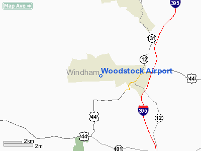
Woodstock Airport
Address:
Windham County, CT
Tel:
203-928-4652
Images
and information placed above are from
http://www.airport-data.com/airport/64CT/
We
thank them for the data!
| General
Info |
| Country |
United
States |
| State |
CONNECTICUT
|
| FAA ID |
64CT
|
| Latitude |
41-55-17.351N
|
| Longitude |
071-57-10.263W
|
| Elevation |
465 feet
|
| Near City |
SOUTH
WOODSTOCK |
We don't guarantee the information is fresh and accurate. The data may
be wrong or outdated.
For more up-to-date information please refer to other sources.
|
|


