 |
|
| Windham Airport |
| IATA: none – ICAO: KIJD – FAA LID: IJD |
| Summary |
| Airport type |
Public |
| Owner |
Connecticut Department of Transportation (ConnDOT) |
| Location |
Willimantic, Connecticut |
| Elevation AMSL |
247 ft / 75 m |
| Coordinates |
41°44′39″N 072°10′49″W / 41.74417°N 72.18028°W / 41.74417; -72.18028 |
| Runways |
| Direction |
Length |
Surface |
| ft |
m |
| 9/27 |
4,278 |
1,304 |
Asphalt |
| 18/36 |
2,797 |
853 |
Asphalt |
| Statistics (2005) |
| Aircraft operations |
30,690 |
| Based aircraft |
67 |
| Source: Federal Aviation Administration |
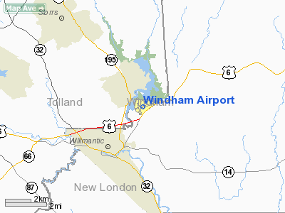
Windham Airport (ICAO: KIJD, FAA LID: IJD) is a public airport located three miles (5 km) northeast of the central business district of Willimantic, a city in Windham County, Connecticut, United States. It is owned by the Connecticut Department of Transportation (ConnDOT).
Although most U.S. airports use the same three-letter location identifier for the FAA and IATA, Windham Airport is assigned IJD by the FAA but has no designation from the IATA.
Facilities and aircraft
Windham Airport covers an area of 280 acres (113 ha) which contains two asphalt paved runways: 9/27 measuring 4,278 x 100 ft (1,304 x 30 m) and 18/36 measuring 2,797 x 75 ft (853 x 23 m).
For the 12-month period ending October 1, 2005, the airport had 30,690 aircraft operations, an average of 84 per day: 98% general aviation, 2% air taxi and <1% military. There are 67 aircraft based at this airport: 93% single engine and 7% multi-engine.
The FBO and Flight School at Windham Airport is owned and operated by Freedom Jets Aviation, LLC. Rentable aircraft include Cessna 152s and 172s, Piper Warriors, and a Piper Arrow.
The above content comes from Wikipedia and is published under free licenses – click here to read more.
Location
& QuickFacts
|
FAA
Information Effective: |
2006-09-28 |
|
Airport
Identifier: |
IJD |
|
Longitude/Latitude: |
072-10-48.8490W/41-44-38.5450N
-72.180236/41.744040 (Estimated) |
|
Elevation: |
247 ft / 75.29 m (Surveyed) |
|
Land: |
280 acres |
|
From
nearest city: |
3 nautical miles NE of Willimantic, CT |
|
Location: |
Windham County, CT |
|
Magnetic Variation: |
15W (1985) |
Owner
& Manager
|
Ownership: |
Publicly owned |
|
Owner: |
State Of Ct Dot |
|
Address: |
2800 Berlin Turnpike
Newington, CT 06131 |
|
Phone
number: |
860-594-2529 |
|
Manager: |
Matthew J. Kelly |
|
Address: |
Bureau Of Aviation & Ports, 2800 Berlin
Turnpike P.o. Box 3175
Newington, CT 06131-7546 |
|
Phone number: |
860-594-2534 |
Airport
Operations and Facilities
|
Airport
Use: |
Open to public |
|
Wind
indicator: |
Yes |
|
Segmented
Circle: |
Yes |
|
Control
Tower: |
No |
|
Attendance
Schedule: |
ALL/ALL/0800-DUSK |
|
Lighting
Schedule: |
DUSK-DAWN
ACTVT MIRL RY 09/27 & REIL RY 27; PAPI RY 27 OPERS 24
HRS - CTAF |
|
Beacon
Color: |
Clear-Green (lighted land airport) |
|
Landing
fee charge: |
No
LANDING FEE FOR BUSINESS/CORPORATE ACFT. |
|
Sectional
chart: |
New York |
|
Region: |
ANE - New England |
|
Traffic
Pattern Alt: |
1000 ft |
|
Boundary
ARTCC: |
ZBW - Boston |
|
Tie-in
FSS: |
BDR - Bridgeport |
|
FSS
on Airport: |
No |
|
FSS
Phone: |
866-293-5149 |
|
FSS
Toll Free: |
1-800-WX-BRIEF |
|
NOTAMs
Facility: |
IJD (NOTAM-d service avaliable) |
|
Federal Agreements: |
NGSY3 |
Airport
Communications
|
CTAF: |
122.975 |
|
Unicom: |
122.975 |
Airport
Services
|
Fuel
available: |
100LLA |
|
Airframe
Repair: |
MAJOR |
|
Power
Plant Repair: |
MAJOR |
|
Bottled
Oxygen: |
NONE |
|
Bulk
Oxygen: |
NONE |
|
Runway Information
Runway 09/27
|
Dimension: |
4278 x 100 ft / 1303.9 x 30.5 m |
|
Surface: |
ASPH, Fair Condition |
|
Weight
Limit: |
Single wheel: 30000 lbs. |
|
Edge
Lights: |
Medium |
| |
Runway 09 |
Runway 27 |
|
Longitude: |
072-11-06.6890W |
072-10-12.3330W |
|
Latitude: |
41-44-36.2590N |
41-44-47.6050N |
|
Elevation: |
240.00 ft |
240.00 ft |
|
Alignment: |
74 |
127 |
|
ILS
Type: |
|
LOC/DME |
|
Traffic
Pattern: |
Left |
Left |
|
Markings: |
Non-precision instrument, Good Condition |
Non-precision instrument, Good Condition |
|
Displaced
threshold: |
261.00 ft |
0.00
ft |
|
VASI: |
|
4-light PAPI on left side |
|
Runway
End Identifier: |
No |
Yes |
|
Obstruction: |
53 ft trees, 210.0 ft from runway, 220 ft left
of centerline
APCH RATIO 25:1 TO DSPLCD THLD.
+45
FT TREES 195 FT FROM THR; 245 FT L. |
36 ft tree, 415.0 ft from runway, 255 ft left
of centerline, 5:1 slope to clear
+8 FT FENCE 61 FT FROM THR 250L; +30 FT TREES 90 FT FROM THR
205L. |
|
Runway 18/36
|
Dimension: |
2797 x 75 ft / 852.5 x 22.9 m |
|
Surface: |
ASPH, Good Condition |
|
Weight
Limit: |
Single wheel: 30000 lbs. |
| |
Runway 18 |
Runway 36 |
|
Longitude: |
072-11-08.3910W |
072-10-57.8660W |
|
Latitude: |
41-44-46.6090N |
41-44-20.1210N |
|
Elevation: |
235.00 ft |
247.00 ft |
|
Alignment: |
127 |
127 |
|
Traffic
Pattern: |
Left |
Left |
|
Markings: |
Basic, Good Condition |
Basic, Good Condition |
|
Displaced
threshold: |
0.00
ft |
799.00 ft |
|
Runway
End Identifier: |
No |
No |
|
Obstruction: |
46 ft trees, 800.0 ft from runway, 200 ft right
of centerline, 13:1 slope to clear |
60 ft trees, 800.0 ft from runway, 50 ft left
of centerline, 10:1 slope to clear
APCH RATIO 20:1 TO DSPLCD THLD. |
|
Radio Navigation
Aids
|
ID |
Type |
Name |
Ch |
Freq |
Var |
Dist |
|
HF |
NDB |
Lomis |
|
244.00 |
15W |
21.0 nm |
|
MMK |
NDB |
Meriden |
|
238.00 |
14W |
32.3 nm |
|
SFZ |
NDB |
Central |
|
241.00 |
15W |
32.7 nm |
|
TBY |
NDB |
Waterbury |
|
257.00 |
14W |
45.2 nm |
|
IHM |
NDB |
Mansfield |
|
220.00 |
16W |
46.7 nm |
|
ORE |
NDB |
Orange |
|
205.00 |
15W |
49.8 nm |
|
ORW |
VOR/DME |
Norwich |
037X |
110.00 |
14W |
13.9 nm |
|
HFD |
VOR/DME |
Hartford |
096X |
114.90 |
13W |
17.6 nm |
|
PUT |
VOR/DME |
Putnam |
121X |
117.40 |
14W |
19.7 nm |
|
GON |
VOR/DME |
Groton |
45Y |
110.85 |
14W |
25.5 nm |
|
MAD |
VOR/DME |
Madison |
041X |
110.40 |
13W |
34.6 nm |
|
HVN |
VOR/DME |
New Haven |
035X |
109.80 |
13W |
43.0 nm |
|
SEY |
VOR/DME |
Sandy Point |
125X |
117.80 |
15W |
44.1 nm |
|
CTR |
VOR/DME |
Chester |
098X |
115.10 |
13W |
47.6 nm |
|
BDL |
VORTAC |
Bradley |
027X |
109.00 |
14W |
25.7 nm |
|
CEF |
VORTAC |
Westover |
87X |
114.00 |
14W |
31.3 nm |
|
PVD |
VORTAC |
Providence |
103X |
115.60 |
14W |
33.7 nm |
|
BAF |
VORTAC |
Barnes |
077X |
113.00 |
14W |
34.7 nm |
|
GDM |
VORTAC |
Gardner |
043X |
110.60 |
14W |
48.5 nm |
|
HTO |
VORTAC |
Hampton |
083X |
113.60 |
13W |
50.0 nm |
|
HFD |
VOT |
Hartford |
|
108.20 |
|
21.1 nm |
|
BDL |
VOT |
Bradley Intl |
|
111.40 |
|
25.4 nm |
|
GON |
VOT |
Groton |
|
110.25 |
|
25.9 nm |
|
PVD |
VOT |
Providence |
|
108.20 |
|
33.8 nm |
|
ORH |
VOT |
Worcester |
|
108.20 |
|
34.4 nm |
Remarks
- EXPECT
ACFT TAXIING ON RY 18/36.
- 4
OBS LGTS ON SURROUNDING HILLS OTS INDEFLY.
- BIRDS
ON & INVOF ARPT.
- EXISTED
PRIOR TO 1959.
Based Aircraft
|
Aircraft
based on field: |
67 |
|
Single
Engine Airplanes: |
62 |
|
Multi
Engine Airplanes: |
5 |
Operational Statistics
|
Aircraft
Operations: |
85/Day |
|
Air Taxi: |
1.5% |
|
General
Aviation Local: |
73.4% |
|
General
Aviation Itinerant: |
24.3% |
|
Military: |
0.8% |
Windham Airport
Address:
Windham County, CT
Tel:
860-594-2529,
860-594-2534
Images
and information placed above are from
http://www.airport-data.com/airport/IJD/
We
thank them for the data!
| General
Info |
| Country |
United
States |
| State |
CONNECTICUT
|
| FAA ID |
IJD
|
| Latitude |
41-44-38.545N
|
| Longitude |
072-10-48.849W
|
| Elevation |
247 feet
|
| Near City |
WILLIMANTIC
|
We don't guarantee the information is fresh and accurate. The data may
be wrong or outdated.
For more up-to-date information please refer to other sources.
|
|


